
Tiree, Beinn Hough, Chain Home Low Radar Station


Radar Station (20th Century)
Site Name Tiree, Beinn Hough, Chain Home Low Radar Station
Classification Radar Station (20th Century)
Alternative Name(s) Beinn Hough
Canmore ID 141164
Site Number NL94NW 8
NGR NL 94829 46254
NGR Description NL 9486 4635 and NL 94829 46254
Datum OSGB36 - NGR
Permalink http://canmore.org.uk/site/141164


- Council Argyll And Bute
- Parish Tiree
- Former Region Strathclyde
- Former District Argyll And Bute
- Former County Argyll
NL94NW 8.00 NL 9486 4635 and 94829 46254
NL94NW 8.01 NL 9444 4694 Building
NL94NW 8.02 NL 9435 4648 and NL 9452 4643 Buildings
NL94NW 8.03 Centred NL 9435 4675 Radar Mast
NL94NW 8.04 NL 95487 45964 and NL 95527 46014 Buildings
NL94NW 8.05 NL 95072 46917 Building
N.B. NL94NW 8.04 and NL94NW 8.05 fall on mapsheet NL94NE
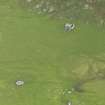
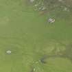
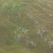
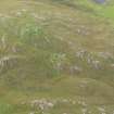
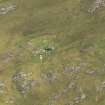
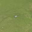
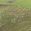
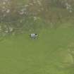
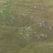
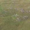
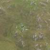
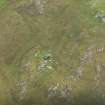
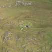
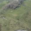
Part of Britain's Radar cover, this Chain Home Low Radar station is situated at the summit of Beinn Hough and on the NW slopes to the N of Loch Earblaig. The site was not visited by Mr Guy, however, two buildings (NL94NW 8.02) are depicted on the current OS 1:10000 map (1976) at NL 9435 4648 and NL 9452 4643, both of which are visible on vertical air photographs (RAF 106G/Scot/UK 34, 3398-3400, flown 26 April 1946. These are possibly the Transmitter(Tx) and Receiver blocks(Rx), with the building at NL 9444 4294 being the remote reserve. Between the two groups of buildings, the vertical air photographs show a series of masts, three of which were still standing in 1946. A further group of buildings and structures visible on the 1946 images are situated on the summit of Beinn Hough. (Information from RCAHMS {DE}, May 2001)
J Guy 2001; NMRS MS 810/11, Part 1, 3-4

