|
Photographs and Off-line Digital Images |
C 41970 CN |
RCAHMS Aerial Photography |
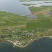
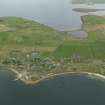
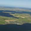
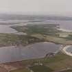
Oblique aerial view from S, centred on the island of Burray and showing Burray Village in the centre left of the photograph, and Churchill Barrier No. 4 in the right centre. N Cara Mound is visible in the centre foreground. |
13/6/1995 |
Item Level |
|
|
Photographs and Off-line Digital Images |
C 41971 CN |
RCAHMS Aerial Photography |
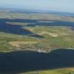
Oblique aerial view from SSE, centred on the island of Burray and showing Burray Village in the centre left of the photograph, and Churchill Barrier No. 4 in the right centre. N Cara Mound is visible in the bottom left-hand corner. |
|
Item Level |
|
|
Photographs and Off-line Digital Images |
C 41972 CN |
RCAHMS Aerial Photography |
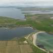
Oblique aerial view, from SE, centred on the island of Burray and Churchill Barrier No. 4, and showing Burray village in the left centre of the photograph. |
13/6/1995 |
Item Level |
|
|
Photographs and Off-line Digital Images |
D 14564 |
RCAHMS Aerial Photography |
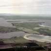
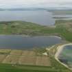
Oblique aerial view of Orkney, South Ronaldsay, Burray and South Ronaldsay, Churchill Barrier No.4 with the village of Burray taken from the S. The view N also shows the Churchill Barriers Nos.1, 2 and 3 with Lamb Holm and Glimps Holm. |
4/8/1997 |
Item Level |
|
|
Photographs and Off-line Digital Images |
D 16752 CN |
RCAHMS Aerial Photography |
Oblique aerial view of Orkney, Burray, general view taken from the S of Burray, Burray village and all four Churchill Barriers. |
4/8/1997 |
Item Level |
|
|
Photographs and Off-line Digital Images |
D 16753 CN |
RCAHMS Aerial Photography |
Oblique aerial view of Orkney, Burray, general view taken from the S of Burray, Burray village and all four Churchill Barriers. |
4/8/1997 |
Item Level |
|
|
Photographs and Off-line Digital Images |
D 16754 CN |
RCAHMS Aerial Photography |
Oblique aerial view of Orkney, Burray, general view taken from the SSE of Burray, part of Burray village and the four Churchill Barriers. |
4/8/1997 |
Item Level |
|
 |
On-line Digital Images |
SC 940810 |
RCAHMS Aerial Photography |
Scanned image of oblique aerial view, from SE, centred on the island of Burray and Churchill Barrier No. 4, and showing Burray village in the left centre of the photograph. |
13/6/1995 |
Item Level |
|
|
Photographs and Off-line Digital Images |
D 14565 |
RCAHMS Aerial Photography |
Oblique aerial view of Orkney, South Ronaldsay, Burray and South Ronaldsay, Churchill Barrier No.4 with the village of Burray taken from the S. The view N also shows the Churchill Barriers Nos.1, 2 and 3 with Lamb Holm and Glimps Holm. |
4/8/1997 |
Item Level |
|
|
Photographs and Off-line Digital Images |
D 14566 |
RCAHMS Aerial Photography |
Oblique aerial view of Orkney, South Ronaldsay, Burray and South Ronaldsay, Churchill Barrier No.4 with the village of Burray taken from the S. The view N also shows the Churchill Barriers Nos.1, 2 and 3 with Lamb Holm and Glimps Holm. |
4/8/1997 |
Item Level |
|
 |
On-line Digital Images |
DP 053235 |
RCAHMS Aerial Photography Digital |
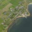
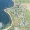
Oblique aerial view centred on the village, taken from the SW. |
23/9/2008 |
Item Level |
|
 |
On-line Digital Images |
DP 053236 |
RCAHMS Aerial Photography Digital |
Oblique aerial view centred on the village, taken from the SSW. |
23/9/2008 |
Item Level |
|
 |
On-line Digital Images |
DP 053237 |
RCAHMS Aerial Photography Digital |
Oblique aerial view centred on the village, taken from the S. |
23/9/2008 |
Item Level |
|
 |
On-line Digital Images |
DP 053238 |
RCAHMS Aerial Photography Digital |
Oblique aerial view centred on the village, taken from the SSE. |
23/9/2008 |
Item Level |
|
 |
On-line Digital Images |
DP 053239 |
RCAHMS Aerial Photography Digital |
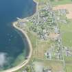
General oblique aerial view centred on the village, taken from the SE. |
23/9/2008 |
Item Level |
|
 |
On-line Digital Images |
DP 053240 |
RCAHMS Aerial Photography Digital |
General oblique aerial view centred on the village, taken from the SE. |
23/9/2008 |
Item Level |
|
|
Photographs and Off-line Digital Images |
SC 1135233 |
Records of the Ordnance Survey, Southampton, Hampshire, England |
Vertical aerial view centred on the Churchill Barrier No.4 with Burray village adjacent. |
16/5/1974 |
Item Level |
|
|
Photographs and Off-line Digital Images |
SC 1135234 |
Records of the Ordnance Survey, Southampton, Hampshire, England |
Vertical aerial view centred on the Churchill Barrier No.4 with Burray village adjacent. |
25/6/1995 |
Item Level |
|
 |
On-line Digital Images |
DP 067961 |
RCAHMS Aerial Photography Digital |
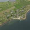
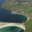
General oblique aerial view looking across Churchill Barrier No. 4 and Water Sound towards the village of Burray, taken from the SE. |
12/5/2009 |
Item Level |
|
 |
On-line Digital Images |
DP 068047 |
RCAHMS Aerial Photography Digital |
Oblique aerial view of Burray with the Churchill Barriers and Mainland beyond, taken from the S. |
5/8/2009 |
Item Level |
|
 |
On-line Digital Images |
DP 068048 |
RCAHMS Aerial Photography Digital |
Oblique aerial view of Burray with the Churchill Barriers and Mainland beyond, taken from the S. |
5/8/2009 |
Item Level |
|
 |
On-line Digital Images |
DP 243828 |
Historic Environment Scotland |
Oblique aerial view. |
16/8/2016 |
Item Level |
|
 |
On-line Digital Images |
DP 243829 |
Historic Environment Scotland |
Oblique aerial view. |
16/8/2016 |
Item Level |
|
 |
On-line Digital Images |
SC 1681899 |
RCAHMS Aerial Photography |
Oblique aerial view from S, centred on the island of Burray and showing Burray Village in the centre left of the photograph, and Churchill Barrier No. 4 in the right centre. N Cara Mound is visible in the centre foreground. |
13/6/1995 |
Item Level |
|


