
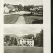
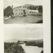
Pitilie


Farmstead (Period Unassigned), Saw Mill (Period Unassigned)
Site Name Pitilie
Classification Farmstead (Period Unassigned), Saw Mill (Period Unassigned)
Alternative Name(s) Pittiely Farm
Canmore ID 140516
Site Number NN84NE 67
NGR NN 8712 4864
Datum OSGB36 - NGR
Permalink http://canmore.org.uk/site/140516
Ordnance Survey licence number AC0000807262. All rights reserved.
Canmore Disclaimer.
© Bluesky International Limited 2025. Public Sector Viewing Terms
- Correction
- Favourite

SC 2154676
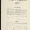
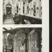
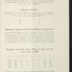
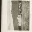
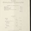
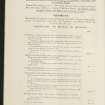
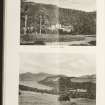
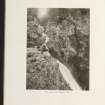
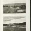
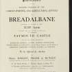
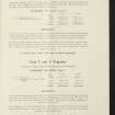
Estate Exchange. Taymouth Castle. No 1526 Sale Brochure Taymouth Castle, Kynachan Lodge, Glenquaich Lodge, Wester Kinloch Farm, Easter Kinloch Farm, Breadalbane Hotel Farm, Croft Nauld & Lynemore Farm, Comrie Farm, Errichel Farm, Borlick Farm, Borland Farm, South Amulree, Easter Auchnafauld, Wester Auchnafauld.
Collection of sale catalogues relating to Scottish estates
9/12/1920
© Courtesy of HES (Estates Exchange Collection)

SC 2154684
Estate Exchange. Taymouth Castle. No 1526 Sale Brochure Taymouth Castle, Kynachan Lodge, Glenquaich Lodge, Wester Kinloch Farm, Easter Kinloch Farm, Breadalbane Hotel Farm, Croft Nauld & Lynemore Farm, Comrie Farm, Errichel Farm, Borlick Farm, Borland Farm, South Amulree, Easter Auchnafauld, Wester Auchnafauld.
Collection of sale catalogues relating to Scottish estates
9/12/1920
© Courtesy of HES (Estates Exchange Collection)

SC 2154695
Estate Exchange. Taymouth Castle. No 1526 Sale Brochure Taymouth Castle, Kynachan Lodge, Glenquaich Lodge, Wester Kinloch Farm, Easter Kinloch Farm, Breadalbane Hotel Farm, Croft Nauld & Lynemore Farm, Comrie Farm, Errichel Farm, Borlick Farm, Borland Farm, South Amulree, Easter Auchnafauld, Wester Auchnafauld.
Collection of sale catalogues relating to Scottish estates
9/12/1920
© Courtesy of HES (Estates Exchange Collection)

SC 2154709
Estate Exchange. Taymouth Castle. No 1526 Sale Brochure Taymouth Castle, Kynachan Lodge, Glenquaich Lodge, Wester Kinloch Farm, Easter Kinloch Farm, Breadalbane Hotel Farm, Croft Nauld & Lynemore Farm, Comrie Farm, Errichel Farm, Borlick Farm, Borland Farm, South Amulree, Easter Auchnafauld, Wester Auchnafauld.
Collection of sale catalogues relating to Scottish estates
9/12/1920
© Courtesy of HES (Estates Exchange Collection)

SC 2154715
Estate Exchange. Taymouth Castle. No 1526 Sale Brochure Taymouth Castle, Kynachan Lodge, Glenquaich Lodge, Wester Kinloch Farm, Easter Kinloch Farm, Breadalbane Hotel Farm, Croft Nauld & Lynemore Farm, Comrie Farm, Errichel Farm, Borlick Farm, Borland Farm, South Amulree, Easter Auchnafauld, Wester Auchnafauld.
Collection of sale catalogues relating to Scottish estates
9/12/1920
© Courtesy of HES (Estates Exchange Collection)

SC 2154670
Estate Exchange. Taymouth Castle. No 1526 Sale Brochure Taymouth Castle, Kynachan Lodge, Glenquaich Lodge, Wester Kinloch Farm, Easter Kinloch Farm, Breadalbane Hotel Farm, Croft Nauld & Lynemore Farm, Comrie Farm, Errichel Farm, Borlick Farm, Borland Farm, South Amulree, Easter Auchnafauld, Wester Auchnafauld.
Collection of sale catalogues relating to Scottish estates
9/12/1920
© Courtesy of HES (Estates Exchange Collection)

SC 2154686
Estate Exchange. Taymouth Castle. No 1526 Sale Brochure Taymouth Castle, Kynachan Lodge, Glenquaich Lodge, Wester Kinloch Farm, Easter Kinloch Farm, Breadalbane Hotel Farm, Croft Nauld & Lynemore Farm, Comrie Farm, Errichel Farm, Borlick Farm, Borland Farm, South Amulree, Easter Auchnafauld, Wester Auchnafauld.
Collection of sale catalogues relating to Scottish estates
9/12/1920
© Courtesy of HES (Estates Exchange Collection)

SC 2154692
Estate Exchange. Taymouth Castle. No 1526 Sale Brochure Taymouth Castle, Kynachan Lodge, Glenquaich Lodge, Wester Kinloch Farm, Easter Kinloch Farm, Breadalbane Hotel Farm, Croft Nauld & Lynemore Farm, Comrie Farm, Errichel Farm, Borlick Farm, Borland Farm, South Amulree, Easter Auchnafauld, Wester Auchnafauld.
Collection of sale catalogues relating to Scottish estates
9/12/1920
© Courtesy of HES (Estates Exchange Collection)

SC 2154697
Estate Exchange. Taymouth Castle. No 1526 Sale Brochure Taymouth Castle, Kynachan Lodge, Glenquaich Lodge, Wester Kinloch Farm, Easter Kinloch Farm, Breadalbane Hotel Farm, Croft Nauld & Lynemore Farm, Comrie Farm, Errichel Farm, Borlick Farm, Borland Farm, South Amulree, Easter Auchnafauld, Wester Auchnafauld.
Collection of sale catalogues relating to Scottish estates
9/12/1920
© Courtesy of HES (Estates Exchange Collection)

SC 2154707
Estate Exchange. Taymouth Castle. No 1526 Sale Brochure Taymouth Castle, Kynachan Lodge, Glenquaich Lodge, Wester Kinloch Farm, Easter Kinloch Farm, Breadalbane Hotel Farm, Croft Nauld & Lynemore Farm, Comrie Farm, Errichel Farm, Borlick Farm, Borland Farm, South Amulree, Easter Auchnafauld, Wester Auchnafauld.
Collection of sale catalogues relating to Scottish estates
9/12/1920
© Courtesy of HES (Estates Exchange Collection)

SC 2154668
Estate Exchange. Taymouth Castle. No 1526 Sale Brochure Taymouth Castle, Kynachan Lodge, Glenquaich Lodge, Wester Kinloch Farm, Easter Kinloch Farm, Breadalbane Hotel Farm, Croft Nauld & Lynemore Farm, Comrie Farm, Errichel Farm, Borlick Farm, Borland Farm, South Amulree, Easter Auchnafauld, Wester Auchnafauld.
Collection of sale catalogues relating to Scottish estates
9/12/1920
© Courtesy of HES (Estates Exchange Collection)

SC 2154675
Estate Exchange. Taymouth Castle. No 1526 Sale Brochure Taymouth Castle, Kynachan Lodge, Glenquaich Lodge, Wester Kinloch Farm, Easter Kinloch Farm, Breadalbane Hotel Farm, Croft Nauld & Lynemore Farm, Comrie Farm, Errichel Farm, Borlick Farm, Borland Farm, South Amulree, Easter Auchnafauld, Wester Auchnafauld.
Collection of sale catalogues relating to Scottish estates
9/12/1920
© Courtesy of HES (Estates Exchange Collection)

SC 2154683
Estate Exchange. Taymouth Castle. No 1526 Sale Brochure Taymouth Castle, Kynachan Lodge, Glenquaich Lodge, Wester Kinloch Farm, Easter Kinloch Farm, Breadalbane Hotel Farm, Croft Nauld & Lynemore Farm, Comrie Farm, Errichel Farm, Borlick Farm, Borland Farm, South Amulree, Easter Auchnafauld, Wester Auchnafauld.
Collection of sale catalogues relating to Scottish estates
9/12/1920
© Courtesy of HES (Estates Exchange Collection)

SC 2154698
Estate Exchange. Taymouth Castle. No 1526 Sale Brochure Taymouth Castle, Kynachan Lodge, Glenquaich Lodge, Wester Kinloch Farm, Easter Kinloch Farm, Breadalbane Hotel Farm, Croft Nauld & Lynemore Farm, Comrie Farm, Errichel Farm, Borlick Farm, Borland Farm, South Amulree, Easter Auchnafauld, Wester Auchnafauld.
Collection of sale catalogues relating to Scottish estates
9/12/1920
© Courtesy of HES (Estates Exchange Collection)

SC 2154704
Estate Exchange. Taymouth Castle. No 1526 Sale Brochure Taymouth Castle, Kynachan Lodge, Glenquaich Lodge, Wester Kinloch Farm, Easter Kinloch Farm, Breadalbane Hotel Farm, Croft Nauld & Lynemore Farm, Comrie Farm, Errichel Farm, Borlick Farm, Borland Farm, South Amulree, Easter Auchnafauld, Wester Auchnafauld.
Collection of sale catalogues relating to Scottish estates
9/12/1920
© Courtesy of HES (Estates Exchange Collection)

SC 2154710
Estate Exchange. Taymouth Castle. No 1526 Sale Brochure Taymouth Castle, Kynachan Lodge, Glenquaich Lodge, Wester Kinloch Farm, Easter Kinloch Farm, Breadalbane Hotel Farm, Croft Nauld & Lynemore Farm, Comrie Farm, Errichel Farm, Borlick Farm, Borland Farm, South Amulree, Easter Auchnafauld, Wester Auchnafauld.
Collection of sale catalogues relating to Scottish estates
9/12/1920
© Courtesy of HES (Estates Exchange Collection)

SC 2154711
Estate Exchange. Taymouth Castle. No 1526 Sale Brochure Taymouth Castle, Kynachan Lodge, Glenquaich Lodge, Wester Kinloch Farm, Easter Kinloch Farm, Breadalbane Hotel Farm, Croft Nauld & Lynemore Farm, Comrie Farm, Errichel Farm, Borlick Farm, Borland Farm, South Amulree, Easter Auchnafauld, Wester Auchnafauld.
Collection of sale catalogues relating to Scottish estates
9/12/1920
© Courtesy of HES (Estates Exchange Collection)

SC 2154713
Estate Exchange. Taymouth Castle. No 1526 Sale Brochure Taymouth Castle, Kynachan Lodge, Glenquaich Lodge, Wester Kinloch Farm, Easter Kinloch Farm, Breadalbane Hotel Farm, Croft Nauld & Lynemore Farm, Comrie Farm, Errichel Farm, Borlick Farm, Borland Farm, South Amulree, Easter Auchnafauld, Wester Auchnafauld.
Collection of sale catalogues relating to Scottish estates
9/12/1920
© Courtesy of HES (Estates Exchange Collection)

SC 2154720
Estate Exchange. Taymouth Castle. No 1526 Sale Brochure Taymouth Castle, Kynachan Lodge, Glenquaich Lodge, Wester Kinloch Farm, Easter Kinloch Farm, Breadalbane Hotel Farm, Croft Nauld & Lynemore Farm, Comrie Farm, Errichel Farm, Borlick Farm, Borland Farm, South Amulree, Easter Auchnafauld, Wester Auchnafauld.
Collection of sale catalogues relating to Scottish estates
9/12/1920
© Courtesy of HES (Estates Exchange Collection)

SC 2154674
Estate Exchange. Taymouth Castle. No 1526 Sale Brochure Taymouth Castle, Kynachan Lodge, Glenquaich Lodge, Wester Kinloch Farm, Easter Kinloch Farm, Breadalbane Hotel Farm, Croft Nauld & Lynemore Farm, Comrie Farm, Errichel Farm, Borlick Farm, Borland Farm, South Amulree, Easter Auchnafauld, Wester Auchnafauld.
Collection of sale catalogues relating to Scottish estates
9/12/1920
© Courtesy of HES (Estates Exchange Collection)

SC 2154690
Estate Exchange. Taymouth Castle. No 1526 Sale Brochure Taymouth Castle, Kynachan Lodge, Glenquaich Lodge, Wester Kinloch Farm, Easter Kinloch Farm, Breadalbane Hotel Farm, Croft Nauld & Lynemore Farm, Comrie Farm, Errichel Farm, Borlick Farm, Borland Farm, South Amulree, Easter Auchnafauld, Wester Auchnafauld.
Collection of sale catalogues relating to Scottish estates
9/12/1920
© Courtesy of HES (Estates Exchange Collection)

SC 2154703
Estate Exchange. Taymouth Castle. No 1526 Sale Brochure Taymouth Castle, Kynachan Lodge, Glenquaich Lodge, Wester Kinloch Farm, Easter Kinloch Farm, Breadalbane Hotel Farm, Croft Nauld & Lynemore Farm, Comrie Farm, Errichel Farm, Borlick Farm, Borland Farm, South Amulree, Easter Auchnafauld, Wester Auchnafauld.
Collection of sale catalogues relating to Scottish estates
9/12/1920
© Courtesy of HES (Estates Exchange Collection)

SC 2154714
Estate Exchange. Taymouth Castle. No 1526 Sale Brochure Taymouth Castle, Kynachan Lodge, Glenquaich Lodge, Wester Kinloch Farm, Easter Kinloch Farm, Breadalbane Hotel Farm, Croft Nauld & Lynemore Farm, Comrie Farm, Errichel Farm, Borlick Farm, Borland Farm, South Amulree, Easter Auchnafauld, Wester Auchnafauld.
Collection of sale catalogues relating to Scottish estates
9/12/1920
© Courtesy of HES (Estates Exchange Collection)

SC 2154687
Estate Exchange. Taymouth Castle. No 1526 Sale Brochure Taymouth Castle, Kynachan Lodge, Glenquaich Lodge, Wester Kinloch Farm, Easter Kinloch Farm, Breadalbane Hotel Farm, Croft Nauld & Lynemore Farm, Comrie Farm, Errichel Farm, Borlick Farm, Borland Farm, South Amulree, Easter Auchnafauld, Wester Auchnafauld.
Collection of sale catalogues relating to Scottish estates
9/12/1920
© Courtesy of HES (Estates Exchange Collection)

SC 2154689
Estate Exchange. Taymouth Castle. No 1526 Sale Brochure Taymouth Castle, Kynachan Lodge, Glenquaich Lodge, Wester Kinloch Farm, Easter Kinloch Farm, Breadalbane Hotel Farm, Croft Nauld & Lynemore Farm, Comrie Farm, Errichel Farm, Borlick Farm, Borland Farm, South Amulree, Easter Auchnafauld, Wester Auchnafauld.
Collection of sale catalogues relating to Scottish estates
9/12/1920
© Courtesy of HES (Estates Exchange Collection)

SC 2154691
Estate Exchange. Taymouth Castle. No 1526 Sale Brochure Taymouth Castle, Kynachan Lodge, Glenquaich Lodge, Wester Kinloch Farm, Easter Kinloch Farm, Breadalbane Hotel Farm, Croft Nauld & Lynemore Farm, Comrie Farm, Errichel Farm, Borlick Farm, Borland Farm, South Amulree, Easter Auchnafauld, Wester Auchnafauld.
Collection of sale catalogues relating to Scottish estates
9/12/1920
© Courtesy of HES (Estates Exchange Collection)

SC 2154696
Estate Exchange. Taymouth Castle. No 1526 Sale Brochure Taymouth Castle, Kynachan Lodge, Glenquaich Lodge, Wester Kinloch Farm, Easter Kinloch Farm, Breadalbane Hotel Farm, Croft Nauld & Lynemore Farm, Comrie Farm, Errichel Farm, Borlick Farm, Borland Farm, South Amulree, Easter Auchnafauld, Wester Auchnafauld.
Collection of sale catalogues relating to Scottish estates
9/12/1920
© Courtesy of HES (Estates Exchange Collection)

SC 2154718
Estate Exchange. Taymouth Castle. No 1526 Sale Brochure Taymouth Castle, Kynachan Lodge, Glenquaich Lodge, Wester Kinloch Farm, Easter Kinloch Farm, Breadalbane Hotel Farm, Croft Nauld & Lynemore Farm, Comrie Farm, Errichel Farm, Borlick Farm, Borland Farm, South Amulree, Easter Auchnafauld, Wester Auchnafauld.
Collection of sale catalogues relating to Scottish estates
9/12/1920
© Courtesy of HES (Estates Exchange Collection)

SC 2154677
Estate Exchange. Taymouth Castle. No 1526 Sale Brochure Taymouth Castle, Kynachan Lodge, Glenquaich Lodge, Wester Kinloch Farm, Easter Kinloch Farm, Breadalbane Hotel Farm, Croft Nauld & Lynemore Farm, Comrie Farm, Errichel Farm, Borlick Farm, Borland Farm, South Amulree, Easter Auchnafauld, Wester Auchnafauld.
Collection of sale catalogues relating to Scottish estates
9/12/1920
© Courtesy of HES (Estates Exchange Collection)

SC 2154685
Estate Exchange. Taymouth Castle. No 1526 Sale Brochure Taymouth Castle, Kynachan Lodge, Glenquaich Lodge, Wester Kinloch Farm, Easter Kinloch Farm, Breadalbane Hotel Farm, Croft Nauld & Lynemore Farm, Comrie Farm, Errichel Farm, Borlick Farm, Borland Farm, South Amulree, Easter Auchnafauld, Wester Auchnafauld.
Collection of sale catalogues relating to Scottish estates
9/12/1920
© Courtesy of HES (Estates Exchange Collection)

SC 2154693
Estate Exchange. Taymouth Castle. No 1526 Sale Brochure Taymouth Castle, Kynachan Lodge, Glenquaich Lodge, Wester Kinloch Farm, Easter Kinloch Farm, Breadalbane Hotel Farm, Croft Nauld & Lynemore Farm, Comrie Farm, Errichel Farm, Borlick Farm, Borland Farm, South Amulree, Easter Auchnafauld, Wester Auchnafauld.
Collection of sale catalogues relating to Scottish estates
9/12/1920
© Courtesy of HES (Estates Exchange Collection)

SC 2154705
Estate Exchange. Taymouth Castle. No 1526 Sale Brochure Taymouth Castle, Kynachan Lodge, Glenquaich Lodge, Wester Kinloch Farm, Easter Kinloch Farm, Breadalbane Hotel Farm, Croft Nauld & Lynemore Farm, Comrie Farm, Errichel Farm, Borlick Farm, Borland Farm, South Amulree, Easter Auchnafauld, Wester Auchnafauld.
Collection of sale catalogues relating to Scottish estates
9/12/1920
© Courtesy of HES (Estates Exchange Collection)

SC 2154719
Estate Exchange. Taymouth Castle. No 1526 Sale Brochure Taymouth Castle, Kynachan Lodge, Glenquaich Lodge, Wester Kinloch Farm, Easter Kinloch Farm, Breadalbane Hotel Farm, Croft Nauld & Lynemore Farm, Comrie Farm, Errichel Farm, Borlick Farm, Borland Farm, South Amulree, Easter Auchnafauld, Wester Auchnafauld.
Collection of sale catalogues relating to Scottish estates
9/12/1920
© Courtesy of HES (Estates Exchange Collection)

SC 2154721
Estate Exchange. Taymouth Castle. No 1526 Sale Brochure Taymouth Castle, Kynachan Lodge, Glenquaich Lodge, Wester Kinloch Farm, Easter Kinloch Farm, Breadalbane Hotel Farm, Croft Nauld & Lynemore Farm, Comrie Farm, Errichel Farm, Borlick Farm, Borland Farm, South Amulree, Easter Auchnafauld, Wester Auchnafauld.
Collection of sale catalogues relating to Scottish estates
9/12/1920
© Courtesy of HES (Estates Exchange Collection)

SC 2154669
Estate Exchange. Taymouth Castle. No 1526 Sale Brochure Taymouth Castle, Kynachan Lodge, Glenquaich Lodge, Wester Kinloch Farm, Easter Kinloch Farm, Breadalbane Hotel Farm, Croft Nauld & Lynemore Farm, Comrie Farm, Errichel Farm, Borlick Farm, Borland Farm, South Amulree, Easter Auchnafauld, Wester Auchnafauld.
Collection of sale catalogues relating to Scottish estates
9/12/1920
© Courtesy of HES (Estates Exchange Collection)

SC 2154671
Estate Exchange. Taymouth Castle. No 1526 Sale Brochure Taymouth Castle, Kynachan Lodge, Glenquaich Lodge, Wester Kinloch Farm, Easter Kinloch Farm, Breadalbane Hotel Farm, Croft Nauld & Lynemore Farm, Comrie Farm, Errichel Farm, Borlick Farm, Borland Farm, South Amulree, Easter Auchnafauld, Wester Auchnafauld.
Collection of sale catalogues relating to Scottish estates
9/12/1920
© Courtesy of HES (Estates Exchange Collection)

SC 2154673
Estate Exchange. Taymouth Castle. No 1526 Sale Brochure Taymouth Castle, Kynachan Lodge, Glenquaich Lodge, Wester Kinloch Farm, Easter Kinloch Farm, Breadalbane Hotel Farm, Croft Nauld & Lynemore Farm, Comrie Farm, Errichel Farm, Borlick Farm, Borland Farm, South Amulree, Easter Auchnafauld, Wester Auchnafauld.
Collection of sale catalogues relating to Scottish estates
9/12/1920
© Courtesy of HES (Estates Exchange Collection)

SC 2154678
Estate Exchange. Taymouth Castle. No 1526 Sale Brochure Taymouth Castle, Kynachan Lodge, Glenquaich Lodge, Wester Kinloch Farm, Easter Kinloch Farm, Breadalbane Hotel Farm, Croft Nauld & Lynemore Farm, Comrie Farm, Errichel Farm, Borlick Farm, Borland Farm, South Amulree, Easter Auchnafauld, Wester Auchnafauld.
Collection of sale catalogues relating to Scottish estates
9/12/1920
© Courtesy of HES (Estates Exchange Collection)

SC 2154680
Estate Exchange. Taymouth Castle. No 1526 Sale Brochure Taymouth Castle, Kynachan Lodge, Glenquaich Lodge, Wester Kinloch Farm, Easter Kinloch Farm, Breadalbane Hotel Farm, Croft Nauld & Lynemore Farm, Comrie Farm, Errichel Farm, Borlick Farm, Borland Farm, South Amulree, Easter Auchnafauld, Wester Auchnafauld.
Collection of sale catalogues relating to Scottish estates
9/12/1920
© Courtesy of HES (Estates Exchange Collection)

SC 2154681
Estate Exchange. Taymouth Castle. No 1526 Sale Brochure Taymouth Castle, Kynachan Lodge, Glenquaich Lodge, Wester Kinloch Farm, Easter Kinloch Farm, Breadalbane Hotel Farm, Croft Nauld & Lynemore Farm, Comrie Farm, Errichel Farm, Borlick Farm, Borland Farm, South Amulree, Easter Auchnafauld, Wester Auchnafauld.
Collection of sale catalogues relating to Scottish estates
9/12/1920
© Courtesy of HES (Estates Exchange Collection)

SC 2154688
Estate Exchange. Taymouth Castle. No 1526 Sale Brochure Taymouth Castle, Kynachan Lodge, Glenquaich Lodge, Wester Kinloch Farm, Easter Kinloch Farm, Breadalbane Hotel Farm, Croft Nauld & Lynemore Farm, Comrie Farm, Errichel Farm, Borlick Farm, Borland Farm, South Amulree, Easter Auchnafauld, Wester Auchnafauld.
Collection of sale catalogues relating to Scottish estates
9/12/1920
© Courtesy of HES (Estates Exchange Collection)

SC 2154694
Estate Exchange. Taymouth Castle. No 1526 Sale Brochure Taymouth Castle, Kynachan Lodge, Glenquaich Lodge, Wester Kinloch Farm, Easter Kinloch Farm, Breadalbane Hotel Farm, Croft Nauld & Lynemore Farm, Comrie Farm, Errichel Farm, Borlick Farm, Borland Farm, South Amulree, Easter Auchnafauld, Wester Auchnafauld.
Collection of sale catalogues relating to Scottish estates
9/12/1920
© Courtesy of HES (Estates Exchange Collection)

SC 2154699
Estate Exchange. Taymouth Castle. No 1526 Sale Brochure Taymouth Castle, Kynachan Lodge, Glenquaich Lodge, Wester Kinloch Farm, Easter Kinloch Farm, Breadalbane Hotel Farm, Croft Nauld & Lynemore Farm, Comrie Farm, Errichel Farm, Borlick Farm, Borland Farm, South Amulree, Easter Auchnafauld, Wester Auchnafauld.
Collection of sale catalogues relating to Scottish estates
9/12/1920
© Courtesy of HES (Estates Exchange Collection)

SC 2154700
Estate Exchange. Taymouth Castle. No 1526 Sale Brochure Taymouth Castle, Kynachan Lodge, Glenquaich Lodge, Wester Kinloch Farm, Easter Kinloch Farm, Breadalbane Hotel Farm, Croft Nauld & Lynemore Farm, Comrie Farm, Errichel Farm, Borlick Farm, Borland Farm, South Amulree, Easter Auchnafauld, Wester Auchnafauld.
Collection of sale catalogues relating to Scottish estates
9/12/1920
© Courtesy of HES (Estates Exchange Collection)

SC 2154701
Estate Exchange. Taymouth Castle. No 1526 Sale Brochure Taymouth Castle, Kynachan Lodge, Glenquaich Lodge, Wester Kinloch Farm, Easter Kinloch Farm, Breadalbane Hotel Farm, Croft Nauld & Lynemore Farm, Comrie Farm, Errichel Farm, Borlick Farm, Borland Farm, South Amulree, Easter Auchnafauld, Wester Auchnafauld.
Collection of sale catalogues relating to Scottish estates
9/12/1920
© Courtesy of HES (Estates Exchange Collection)

SC 2154706
Estate Exchange. Taymouth Castle. No 1526 Sale Brochure Taymouth Castle, Kynachan Lodge, Glenquaich Lodge, Wester Kinloch Farm, Easter Kinloch Farm, Breadalbane Hotel Farm, Croft Nauld & Lynemore Farm, Comrie Farm, Errichel Farm, Borlick Farm, Borland Farm, South Amulree, Easter Auchnafauld, Wester Auchnafauld.
Collection of sale catalogues relating to Scottish estates
9/12/1920
© Courtesy of HES (Estates Exchange Collection)

SC 2154722
Estate Exchange. Taymouth Castle. No 1526 Sale Brochure Taymouth Castle, Kynachan Lodge, Glenquaich Lodge, Wester Kinloch Farm, Easter Kinloch Farm, Breadalbane Hotel Farm, Croft Nauld & Lynemore Farm, Comrie Farm, Errichel Farm, Borlick Farm, Borland Farm, South Amulree, Easter Auchnafauld, Wester Auchnafauld.
Collection of sale catalogues relating to Scottish estates
9/12/1920
© Courtesy of HES (Estates Exchange Collection)

SC 2154672
Estate Exchange. Taymouth Castle. No 1526 Sale Brochure Taymouth Castle, Kynachan Lodge, Glenquaich Lodge, Wester Kinloch Farm, Easter Kinloch Farm, Breadalbane Hotel Farm, Croft Nauld & Lynemore Farm, Comrie Farm, Errichel Farm, Borlick Farm, Borland Farm, South Amulree, Easter Auchnafauld, Wester Auchnafauld.
Collection of sale catalogues relating to Scottish estates
9/12/1920
© Courtesy of HES (Estates Exchange Collection)

SC 2154679
Estate Exchange. Taymouth Castle. No 1526 Sale Brochure Taymouth Castle, Kynachan Lodge, Glenquaich Lodge, Wester Kinloch Farm, Easter Kinloch Farm, Breadalbane Hotel Farm, Croft Nauld & Lynemore Farm, Comrie Farm, Errichel Farm, Borlick Farm, Borland Farm, South Amulree, Easter Auchnafauld, Wester Auchnafauld.
Collection of sale catalogues relating to Scottish estates
9/12/1920
© Courtesy of HES (Estates Exchange Collection)

SC 2154682
Estate Exchange. Taymouth Castle. No 1526 Sale Brochure Taymouth Castle, Kynachan Lodge, Glenquaich Lodge, Wester Kinloch Farm, Easter Kinloch Farm, Breadalbane Hotel Farm, Croft Nauld & Lynemore Farm, Comrie Farm, Errichel Farm, Borlick Farm, Borland Farm, South Amulree, Easter Auchnafauld, Wester Auchnafauld.
Collection of sale catalogues relating to Scottish estates
9/12/1920
© Courtesy of HES (Estates Exchange Collection)

SC 2154702
Estate Exchange. Taymouth Castle. No 1526 Sale Brochure Taymouth Castle, Kynachan Lodge, Glenquaich Lodge, Wester Kinloch Farm, Easter Kinloch Farm, Breadalbane Hotel Farm, Croft Nauld & Lynemore Farm, Comrie Farm, Errichel Farm, Borlick Farm, Borland Farm, South Amulree, Easter Auchnafauld, Wester Auchnafauld.
Collection of sale catalogues relating to Scottish estates
9/12/1920
© Courtesy of HES (Estates Exchange Collection)

SC 2154708
Estate Exchange. Taymouth Castle. No 1526 Sale Brochure Taymouth Castle, Kynachan Lodge, Glenquaich Lodge, Wester Kinloch Farm, Easter Kinloch Farm, Breadalbane Hotel Farm, Croft Nauld & Lynemore Farm, Comrie Farm, Errichel Farm, Borlick Farm, Borland Farm, South Amulree, Easter Auchnafauld, Wester Auchnafauld.
Collection of sale catalogues relating to Scottish estates
9/12/1920
© Courtesy of HES (Estates Exchange Collection)

SC 2154712
Estate Exchange. Taymouth Castle. No 1526 Sale Brochure Taymouth Castle, Kynachan Lodge, Glenquaich Lodge, Wester Kinloch Farm, Easter Kinloch Farm, Breadalbane Hotel Farm, Croft Nauld & Lynemore Farm, Comrie Farm, Errichel Farm, Borlick Farm, Borland Farm, South Amulree, Easter Auchnafauld, Wester Auchnafauld.
Collection of sale catalogues relating to Scottish estates
9/12/1920
© Courtesy of HES (Estates Exchange Collection)

SC 2154716
Estate Exchange. Taymouth Castle. No 1526 Sale Brochure Taymouth Castle, Kynachan Lodge, Glenquaich Lodge, Wester Kinloch Farm, Easter Kinloch Farm, Breadalbane Hotel Farm, Croft Nauld & Lynemore Farm, Comrie Farm, Errichel Farm, Borlick Farm, Borland Farm, South Amulree, Easter Auchnafauld, Wester Auchnafauld.
Collection of sale catalogues relating to Scottish estates
9/12/1920
© Courtesy of HES (Estates Exchange Collection)

SC 2154717
Estate Exchange. Taymouth Castle. No 1526 Sale Brochure Taymouth Castle, Kynachan Lodge, Glenquaich Lodge, Wester Kinloch Farm, Easter Kinloch Farm, Breadalbane Hotel Farm, Croft Nauld & Lynemore Farm, Comrie Farm, Errichel Farm, Borlick Farm, Borland Farm, South Amulree, Easter Auchnafauld, Wester Auchnafauld.
Collection of sale catalogues relating to Scottish estates
9/12/1920
© Courtesy of HES (Estates Exchange Collection)


- Council Perth And Kinross
- Parish Dull
- Former Region Tayside
- Former District Perth And Kinross
- Former County Perthshire
Note
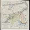
A farmstead comprising one roofed, two unroofed buildings and one enclosure, and a roofed building annotated as a saw mill are depicted on the 1st edition of the OS 6-inch map (Perthshire 1867, sheet xlix).
Two roofed buildings and two enclosures are shown on the current edition of the OS 1:10000 map (1977).
Information from RCAHMS (SAH), 4 November 1997.

