
Following the launch of trove.scot in February 2025 we are now planning the retiral of some of our webservices. Canmore will be switched off on 24th June 2025. Information about the closure can be found on the HES website: Retiral of HES web services | Historic Environment Scotland
Balnacraig


Farmstead (Period Unassigned)
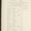
Site Name Balnacraig
Classification Farmstead (Period Unassigned)
Canmore ID 140438
Site Number NN74NW 53
NGR NN 74900 47301
Datum OSGB36 - NGR
Permalink http://canmore.org.uk/site/140438
Ordnance Survey licence number AC0000807262. All rights reserved.
Canmore Disclaimer.
© Bluesky International Limited 2025. Public Sector Viewing Terms
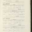
- Correction
- Favourite

SC 1689384
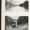
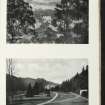
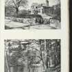
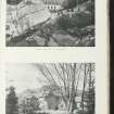
Oblique aerial view centred on the farmstead, taken from the SE.
RCAHMS Aerial Photography
16/3/2001
© Crown Copyright: HES

SC 1689386
Oblique aerial view centred on the farmstead, taken from the NNW.
RCAHMS Aerial Photography
16/3/2001
© Crown Copyright: HES

SC 2152049
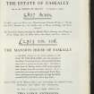
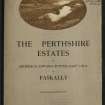
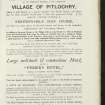
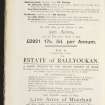
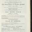
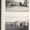
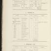
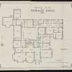
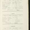
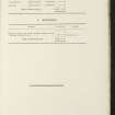
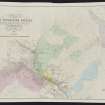
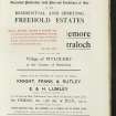
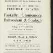
The Perthshire Estates Estate Exhange, no. 1519 Sales Brochure. Includes details of The Perthshire Estates (Ballyoukan House, Knockdarroch, Killiecrankie House, Coilvoulin Farm, Collerton Farm, Faskally Home farm, Straloch Lodge). Title: 'The Perthshire Estates of Archibald Edward Butter Esq. C.M.G. of Faskally.'
Collection of sale catalogues relating to Scottish estates
15/7/1910
© Courtesy of HES (Estates Exchange Collection)

SC 2152050
The Perthshire Estates Estate Exhange, no. 1519 Sales Brochure. Includes details of The Perthshire Estates (Ballyoukan House, Knockdarroch, Killiecrankie House, Coilvoulin Farm, Collerton Farm, Faskally Home farm, Straloch Lodge). Title: 'The Perthshire Estates of Archibald Edward Butter Esq. C.M.G. of Faskally.'
Collection of sale catalogues relating to Scottish estates
15/7/1910
© Courtesy of HES (Estates Exchange Collection)

SC 2152052
The Perthshire Estates Estate Exhange, no. 1519 Sales Brochure. Includes details of The Perthshire Estates (Ballyoukan House, Knockdarroch, Killiecrankie House, Coilvoulin Farm, Collerton Farm, Faskally Home farm, Straloch Lodge). Title: 'The Perthshire Estates of Archibald Edward Butter Esq. C.M.G. of Faskally.'
Collection of sale catalogues relating to Scottish estates
15/7/1910
© Courtesy of HES (Estates Exchange Collection)

SC 2152060
The Perthshire Estates Estate Exhange, no. 1519 Sales Brochure. Includes details of The Perthshire Estates (Ballyoukan House, Knockdarroch, Killiecrankie House, Coilvoulin Farm, Collerton Farm, Faskally Home farm, Straloch Lodge). Title: 'The Perthshire Estates of Archibald Edward Butter Esq. C.M.G. of Faskally.'
Collection of sale catalogues relating to Scottish estates
15/7/1910
© Courtesy of HES (Estates Exchange Collection)

SC 2152074
The Perthshire Estates Estate Exhange, no. 1519 Sales Brochure. Includes details of The Perthshire Estates (Ballyoukan House, Knockdarroch, Killiecrankie House, Coilvoulin Farm, Collerton Farm, Faskally Home farm, Straloch Lodge). Title: 'The Perthshire Estates of Archibald Edward Butter Esq. C.M.G. of Faskally.'
Collection of sale catalogues relating to Scottish estates
15/7/1910
© Courtesy of HES (Estates Exchange Collection)

SC 2152086
The Perthshire Estates Estate Exhange, no. 1519 Sales Brochure. Includes details of The Perthshire Estates (Ballyoukan House, Knockdarroch, Killiecrankie House, Coilvoulin Farm, Collerton Farm, Faskally Home farm, Straloch Lodge). Title: 'The Perthshire Estates of Archibald Edward Butter Esq. C.M.G. of Faskally.'
Collection of sale catalogues relating to Scottish estates
15/7/1910
© Courtesy of HES (Estates Exchange Collection)

SC 2152096
The Perthshire Estates Estate Exhange, no. 1519 Sales Brochure. Includes details of The Perthshire Estates (Ballyoukan House, Knockdarroch, Killiecrankie House, Coilvoulin Farm, Collerton Farm, Faskally Home farm, Straloch Lodge). Title: 'The Perthshire Estates of Archibald Edward Butter Esq. C.M.G. of Faskally.'
Collection of sale catalogues relating to Scottish estates
15/7/1910
© Courtesy of HES (Estates Exchange Collection)

SC 2152039
The Perthshire Estates Estate Exhange, no. 1519 Sales Brochure. Includes details of The Perthshire Estates (Ballyoukan House, Knockdarroch, Killiecrankie House, Coilvoulin Farm, Collerton Farm, Faskally Home farm, Straloch Lodge). Title: 'The Perthshire Estates of Archibald Edward Butter Esq. C.M.G. of Faskally.'
Collection of sale catalogues relating to Scottish estates
15/7/1910
© Courtesy of HES (Estates Exchange Collection)

SC 2152046
The Perthshire Estates Estate Exhange, no. 1519 Sales Brochure. Includes details of The Perthshire Estates (Ballyoukan House, Knockdarroch, Killiecrankie House, Coilvoulin Farm, Collerton Farm, Faskally Home farm, Straloch Lodge). Title: 'The Perthshire Estates of Archibald Edward Butter Esq. C.M.G. of Faskally.'
Collection of sale catalogues relating to Scottish estates
15/7/1910
© Courtesy of HES (Estates Exchange Collection)

SC 2152048
The Perthshire Estates Estate Exhange, no. 1519 Sales Brochure. Includes details of The Perthshire Estates (Ballyoukan House, Knockdarroch, Killiecrankie House, Coilvoulin Farm, Collerton Farm, Faskally Home farm, Straloch Lodge). Title: 'The Perthshire Estates of Archibald Edward Butter Esq. C.M.G. of Faskally.'
Collection of sale catalogues relating to Scottish estates
15/7/1910
© Courtesy of HES (Estates Exchange Collection)

SC 2152071
The Perthshire Estates Estate Exhange, no. 1519 Sales Brochure. Includes details of The Perthshire Estates (Ballyoukan House, Knockdarroch, Killiecrankie House, Coilvoulin Farm, Collerton Farm, Faskally Home farm, Straloch Lodge). Title: 'The Perthshire Estates of Archibald Edward Butter Esq. C.M.G. of Faskally.'
Collection of sale catalogues relating to Scottish estates
15/7/1910
© Courtesy of HES (Estates Exchange Collection)

SC 2152072
The Perthshire Estates Estate Exhange, no. 1519 Sales Brochure. Includes details of The Perthshire Estates (Ballyoukan House, Knockdarroch, Killiecrankie House, Coilvoulin Farm, Collerton Farm, Faskally Home farm, Straloch Lodge). Title: 'The Perthshire Estates of Archibald Edward Butter Esq. C.M.G. of Faskally.'
Collection of sale catalogues relating to Scottish estates
15/7/1910
© Courtesy of HES (Estates Exchange Collection)

SC 2152073
The Perthshire Estates Estate Exhange, no. 1519 Sales Brochure. Includes details of The Perthshire Estates (Ballyoukan House, Knockdarroch, Killiecrankie House, Coilvoulin Farm, Collerton Farm, Faskally Home farm, Straloch Lodge). Title: 'The Perthshire Estates of Archibald Edward Butter Esq. C.M.G. of Faskally.'
Collection of sale catalogues relating to Scottish estates
15/7/1910
© Courtesy of HES (Estates Exchange Collection)

SC 2152075
The Perthshire Estates Estate Exhange, no. 1519 Sales Brochure. Includes details of The Perthshire Estates (Ballyoukan House, Knockdarroch, Killiecrankie House, Coilvoulin Farm, Collerton Farm, Faskally Home farm, Straloch Lodge). Title: 'The Perthshire Estates of Archibald Edward Butter Esq. C.M.G. of Faskally.'
Collection of sale catalogues relating to Scottish estates
15/7/1910
© Courtesy of HES (Estates Exchange Collection)

SC 2152080
The Perthshire Estates Estate Exhange, no. 1519 Sales Brochure. Includes details of The Perthshire Estates (Ballyoukan House, Knockdarroch, Killiecrankie House, Coilvoulin Farm, Collerton Farm, Faskally Home farm, Straloch Lodge). Title: 'The Perthshire Estates of Archibald Edward Butter Esq. C.M.G. of Faskally.'
Collection of sale catalogues relating to Scottish estates
15/7/1910
© Courtesy of HES (Estates Exchange Collection)

SC 2152083
The Perthshire Estates Estate Exhange, no. 1519 Sales Brochure. Includes details of The Perthshire Estates (Ballyoukan House, Knockdarroch, Killiecrankie House, Coilvoulin Farm, Collerton Farm, Faskally Home farm, Straloch Lodge). Title: 'The Perthshire Estates of Archibald Edward Butter Esq. C.M.G. of Faskally.'
Collection of sale catalogues relating to Scottish estates
15/7/1910
© Courtesy of HES (Estates Exchange Collection)

SC 2152090
The Perthshire Estates Estate Exhange, no. 1519 Sales Brochure. Includes details of The Perthshire Estates (Ballyoukan House, Knockdarroch, Killiecrankie House, Coilvoulin Farm, Collerton Farm, Faskally Home farm, Straloch Lodge). Title: 'The Perthshire Estates of Archibald Edward Butter Esq. C.M.G. of Faskally.'
Collection of sale catalogues relating to Scottish estates
15/7/1910
© Courtesy of HES (Estates Exchange Collection)

SC 2152092
The Perthshire Estates Estate Exhange, no. 1519 Sales Brochure. Includes details of The Perthshire Estates (Ballyoukan House, Knockdarroch, Killiecrankie House, Coilvoulin Farm, Collerton Farm, Faskally Home farm, Straloch Lodge). Title: 'The Perthshire Estates of Archibald Edward Butter Esq. C.M.G. of Faskally.'
Collection of sale catalogues relating to Scottish estates
15/7/1910
© Courtesy of HES (Estates Exchange Collection)

SC 2152094
The Perthshire Estates Estate Exhange, no. 1519 Sales Brochure. Includes details of The Perthshire Estates (Ballyoukan House, Knockdarroch, Killiecrankie House, Coilvoulin Farm, Collerton Farm, Faskally Home farm, Straloch Lodge). Title: 'The Perthshire Estates of Archibald Edward Butter Esq. C.M.G. of Faskally.'
Collection of sale catalogues relating to Scottish estates
15/7/1910
© Courtesy of HES (Estates Exchange Collection)

SC 2152042
The Perthshire Estates Estate Exhange, no. 1519 Sales Brochure. Includes details of The Perthshire Estates (Ballyoukan House, Knockdarroch, Killiecrankie House, Coilvoulin Farm, Collerton Farm, Faskally Home farm, Straloch Lodge). Title: 'The Perthshire Estates of Archibald Edward Butter Esq. C.M.G. of Faskally.'
Collection of sale catalogues relating to Scottish estates
15/7/1910
© Courtesy of HES (Estates Exchange Collection)

SC 2152059
The Perthshire Estates Estate Exhange, no. 1519 Sales Brochure. Includes details of The Perthshire Estates (Ballyoukan House, Knockdarroch, Killiecrankie House, Coilvoulin Farm, Collerton Farm, Faskally Home farm, Straloch Lodge). Title: 'The Perthshire Estates of Archibald Edward Butter Esq. C.M.G. of Faskally.'
Collection of sale catalogues relating to Scottish estates
15/7/1910
© Courtesy of HES (Estates Exchange Collection)

SC 2152062
The Perthshire Estates Estate Exhange, no. 1519 Sales Brochure. Includes details of The Perthshire Estates (Ballyoukan House, Knockdarroch, Killiecrankie House, Coilvoulin Farm, Collerton Farm, Faskally Home farm, Straloch Lodge). Title: 'The Perthshire Estates of Archibald Edward Butter Esq. C.M.G. of Faskally.'
Collection of sale catalogues relating to Scottish estates
15/7/1910
© Courtesy of HES (Estates Exchange Collection)

SC 2152068
The Perthshire Estates Estate Exhange, no. 1519 Sales Brochure. Includes details of The Perthshire Estates (Ballyoukan House, Knockdarroch, Killiecrankie House, Coilvoulin Farm, Collerton Farm, Faskally Home farm, Straloch Lodge). Title: 'The Perthshire Estates of Archibald Edward Butter Esq. C.M.G. of Faskally.'
Collection of sale catalogues relating to Scottish estates
15/7/1910
© Courtesy of HES (Estates Exchange Collection)

SC 2152070
The Perthshire Estates Estate Exhange, no. 1519 Sales Brochure. Includes details of The Perthshire Estates (Ballyoukan House, Knockdarroch, Killiecrankie House, Coilvoulin Farm, Collerton Farm, Faskally Home farm, Straloch Lodge). Title: 'The Perthshire Estates of Archibald Edward Butter Esq. C.M.G. of Faskally.'
Collection of sale catalogues relating to Scottish estates
15/7/1910
© Courtesy of HES (Estates Exchange Collection)

SC 2152078
The Perthshire Estates Estate Exhange, no. 1519 Sales Brochure. Includes details of The Perthshire Estates (Ballyoukan House, Knockdarroch, Killiecrankie House, Coilvoulin Farm, Collerton Farm, Faskally Home farm, Straloch Lodge). Title: 'The Perthshire Estates of Archibald Edward Butter Esq. C.M.G. of Faskally.'
Collection of sale catalogues relating to Scottish estates
15/7/1910
© Courtesy of HES (Estates Exchange Collection)

SC 2152095
The Perthshire Estates Estate Exhange, no. 1519 Sales Brochure. Includes details of The Perthshire Estates (Ballyoukan House, Knockdarroch, Killiecrankie House, Coilvoulin Farm, Collerton Farm, Faskally Home farm, Straloch Lodge). Title: 'The Perthshire Estates of Archibald Edward Butter Esq. C.M.G. of Faskally.'
Collection of sale catalogues relating to Scottish estates
15/7/1910
© Courtesy of HES (Estates Exchange Collection)

SC 1689388
Oblique aerial view centred on the farmstead, taken from the SSW.
RCAHMS Aerial Photography
16/3/2001
© Crown Copyright: HES

SC 2152040
The Perthshire Estates Estate Exhange, no. 1519 Sales Brochure. Includes details of The Perthshire Estates (Ballyoukan House, Knockdarroch, Killiecrankie House, Coilvoulin Farm, Collerton Farm, Faskally Home farm, Straloch Lodge). Title: 'The Perthshire Estates of Archibald Edward Butter Esq. C.M.G. of Faskally.'
Collection of sale catalogues relating to Scottish estates
15/7/1910
© Courtesy of HES (Estates Exchange Collection)

SC 2152041
The Perthshire Estates Estate Exhange, no. 1519 Sales Brochure. Includes details of The Perthshire Estates (Ballyoukan House, Knockdarroch, Killiecrankie House, Coilvoulin Farm, Collerton Farm, Faskally Home farm, Straloch Lodge). Title: 'The Perthshire Estates of Archibald Edward Butter Esq. C.M.G. of Faskally.'
Collection of sale catalogues relating to Scottish estates
15/7/1910
© Courtesy of HES (Estates Exchange Collection)

SC 2152054
The Perthshire Estates Estate Exhange, no. 1519 Sales Brochure. Includes details of The Perthshire Estates (Ballyoukan House, Knockdarroch, Killiecrankie House, Coilvoulin Farm, Collerton Farm, Faskally Home farm, Straloch Lodge). Title: 'The Perthshire Estates of Archibald Edward Butter Esq. C.M.G. of Faskally.'
Collection of sale catalogues relating to Scottish estates
15/7/1910
© Courtesy of HES (Estates Exchange Collection)

SC 2152065
The Perthshire Estates Estate Exhange, no. 1519 Sales Brochure. Includes details of The Perthshire Estates (Ballyoukan House, Knockdarroch, Killiecrankie House, Coilvoulin Farm, Collerton Farm, Faskally Home farm, Straloch Lodge). Title: 'The Perthshire Estates of Archibald Edward Butter Esq. C.M.G. of Faskally.'
Collection of sale catalogues relating to Scottish estates
15/7/1910
© Courtesy of HES (Estates Exchange Collection)

SC 2152067
The Perthshire Estates Estate Exhange, no. 1519 Sales Brochure. Includes details of The Perthshire Estates (Ballyoukan House, Knockdarroch, Killiecrankie House, Coilvoulin Farm, Collerton Farm, Faskally Home farm, Straloch Lodge). Title: 'The Perthshire Estates of Archibald Edward Butter Esq. C.M.G. of Faskally.'
Collection of sale catalogues relating to Scottish estates
15/7/1910
© Courtesy of HES (Estates Exchange Collection)

SC 2152088
The Perthshire Estates Estate Exhange, no. 1519 Sales Brochure. Includes details of The Perthshire Estates (Ballyoukan House, Knockdarroch, Killiecrankie House, Coilvoulin Farm, Collerton Farm, Faskally Home farm, Straloch Lodge). Title: 'The Perthshire Estates of Archibald Edward Butter Esq. C.M.G. of Faskally.'
Collection of sale catalogues relating to Scottish estates
15/7/1910
© Courtesy of HES (Estates Exchange Collection)

SC 2152093
The Perthshire Estates Estate Exhange, no. 1519 Sales Brochure. Includes details of The Perthshire Estates (Ballyoukan House, Knockdarroch, Killiecrankie House, Coilvoulin Farm, Collerton Farm, Faskally Home farm, Straloch Lodge). Title: 'The Perthshire Estates of Archibald Edward Butter Esq. C.M.G. of Faskally.'
Collection of sale catalogues relating to Scottish estates
15/7/1910
© Courtesy of HES (Estates Exchange Collection)

SC 2152051
The Perthshire Estates Estate Exhange, no. 1519 Sales Brochure. Includes details of The Perthshire Estates (Ballyoukan House, Knockdarroch, Killiecrankie House, Coilvoulin Farm, Collerton Farm, Faskally Home farm, Straloch Lodge). Title: 'The Perthshire Estates of Archibald Edward Butter Esq. C.M.G. of Faskally.'
Collection of sale catalogues relating to Scottish estates
15/7/1910
© Courtesy of HES (Estates Exchange Collection)

SC 2152063
The Perthshire Estates Estate Exhange, no. 1519 Sales Brochure. Includes details of The Perthshire Estates (Ballyoukan House, Knockdarroch, Killiecrankie House, Coilvoulin Farm, Collerton Farm, Faskally Home farm, Straloch Lodge). Title: 'The Perthshire Estates of Archibald Edward Butter Esq. C.M.G. of Faskally.'
Collection of sale catalogues relating to Scottish estates
15/7/1910
© Courtesy of HES (Estates Exchange Collection)

SC 2152069
The Perthshire Estates Estate Exhange, no. 1519 Sales Brochure. Includes details of The Perthshire Estates (Ballyoukan House, Knockdarroch, Killiecrankie House, Coilvoulin Farm, Collerton Farm, Faskally Home farm, Straloch Lodge). Title: 'The Perthshire Estates of Archibald Edward Butter Esq. C.M.G. of Faskally.'
Collection of sale catalogues relating to Scottish estates
15/7/1910
© Courtesy of HES (Estates Exchange Collection)

SC 2152076
The Perthshire Estates Estate Exhange, no. 1519 Sales Brochure. Includes details of The Perthshire Estates (Ballyoukan House, Knockdarroch, Killiecrankie House, Coilvoulin Farm, Collerton Farm, Faskally Home farm, Straloch Lodge). Title: 'The Perthshire Estates of Archibald Edward Butter Esq. C.M.G. of Faskally.'
Collection of sale catalogues relating to Scottish estates
15/7/1910
© Courtesy of HES (Estates Exchange Collection)

SC 2152077
The Perthshire Estates Estate Exhange, no. 1519 Sales Brochure. Includes details of The Perthshire Estates (Ballyoukan House, Knockdarroch, Killiecrankie House, Coilvoulin Farm, Collerton Farm, Faskally Home farm, Straloch Lodge). Title: 'The Perthshire Estates of Archibald Edward Butter Esq. C.M.G. of Faskally.'
Collection of sale catalogues relating to Scottish estates
15/7/1910
© Courtesy of HES (Estates Exchange Collection)

SC 2152082
The Perthshire Estates Estate Exhange, no. 1519 Sales Brochure. Includes details of The Perthshire Estates (Ballyoukan House, Knockdarroch, Killiecrankie House, Coilvoulin Farm, Collerton Farm, Faskally Home farm, Straloch Lodge). Title: 'The Perthshire Estates of Archibald Edward Butter Esq. C.M.G. of Faskally.'
Collection of sale catalogues relating to Scottish estates
15/7/1910
© Courtesy of HES (Estates Exchange Collection)

SC 2152089
The Perthshire Estates Estate Exhange, no. 1519 Sales Brochure. Includes details of The Perthshire Estates (Ballyoukan House, Knockdarroch, Killiecrankie House, Coilvoulin Farm, Collerton Farm, Faskally Home farm, Straloch Lodge). Title: 'The Perthshire Estates of Archibald Edward Butter Esq. C.M.G. of Faskally.'
Collection of sale catalogues relating to Scottish estates
15/7/1910
© Courtesy of HES (Estates Exchange Collection)

SC 2152091
The Perthshire Estates Estate Exhange, no. 1519 Sales Brochure. Includes details of The Perthshire Estates (Ballyoukan House, Knockdarroch, Killiecrankie House, Coilvoulin Farm, Collerton Farm, Faskally Home farm, Straloch Lodge). Title: 'The Perthshire Estates of Archibald Edward Butter Esq. C.M.G. of Faskally.'
Collection of sale catalogues relating to Scottish estates
15/7/1910
© Courtesy of HES (Estates Exchange Collection)

SC 1689387
Oblique aerial view centred on the farmstead, taken from the W.
RCAHMS Aerial Photography
16/3/2001
© Crown Copyright: HES

SC 2152045
The Perthshire Estates Estate Exhange, no. 1519 Sales Brochure. Includes details of The Perthshire Estates (Ballyoukan House, Knockdarroch, Killiecrankie House, Coilvoulin Farm, Collerton Farm, Faskally Home farm, Straloch Lodge). Title: 'The Perthshire Estates of Archibald Edward Butter Esq. C.M.G. of Faskally.'
Collection of sale catalogues relating to Scottish estates
15/7/1910
© Courtesy of HES (Estates Exchange Collection)

SC 2152047
The Perthshire Estates Estate Exhange, no. 1519 Sales Brochure. Includes details of The Perthshire Estates (Ballyoukan House, Knockdarroch, Killiecrankie House, Coilvoulin Farm, Collerton Farm, Faskally Home farm, Straloch Lodge). Title: 'The Perthshire Estates of Archibald Edward Butter Esq. C.M.G. of Faskally.'
Collection of sale catalogues relating to Scottish estates
15/7/1910
© Courtesy of HES (Estates Exchange Collection)

SC 2152053
The Perthshire Estates Estate Exhange, no. 1519 Sales Brochure. Includes details of The Perthshire Estates (Ballyoukan House, Knockdarroch, Killiecrankie House, Coilvoulin Farm, Collerton Farm, Faskally Home farm, Straloch Lodge). Title: 'The Perthshire Estates of Archibald Edward Butter Esq. C.M.G. of Faskally.'
Collection of sale catalogues relating to Scottish estates
15/7/1910
© Courtesy of HES (Estates Exchange Collection)

SC 2152057
The Perthshire Estates Estate Exhange, no. 1519 Sales Brochure. Includes details of The Perthshire Estates (Ballyoukan House, Knockdarroch, Killiecrankie House, Coilvoulin Farm, Collerton Farm, Faskally Home farm, Straloch Lodge). Title: 'The Perthshire Estates of Archibald Edward Butter Esq. C.M.G. of Faskally.'
Collection of sale catalogues relating to Scottish estates
15/7/1910
© Courtesy of HES (Estates Exchange Collection)

SC 2152079
The Perthshire Estates Estate Exhange, no. 1519 Sales Brochure. Includes details of The Perthshire Estates (Ballyoukan House, Knockdarroch, Killiecrankie House, Coilvoulin Farm, Collerton Farm, Faskally Home farm, Straloch Lodge). Title: 'The Perthshire Estates of Archibald Edward Butter Esq. C.M.G. of Faskally.'
Collection of sale catalogues relating to Scottish estates
15/7/1910
© Courtesy of HES (Estates Exchange Collection)

SC 2152087
The Perthshire Estates Estate Exhange, no. 1519 Sales Brochure. Includes details of The Perthshire Estates (Ballyoukan House, Knockdarroch, Killiecrankie House, Coilvoulin Farm, Collerton Farm, Faskally Home farm, Straloch Lodge). Title: 'The Perthshire Estates of Archibald Edward Butter Esq. C.M.G. of Faskally.'
Collection of sale catalogues relating to Scottish estates
15/7/1910
© Courtesy of HES (Estates Exchange Collection)

SC 2152098
The Perthshire Estates Estate Exhange, no. 1519 Sales Brochure. Includes details of The Perthshire Estates (Ballyoukan House, Knockdarroch, Killiecrankie House, Coilvoulin Farm, Collerton Farm, Faskally Home farm, Straloch Lodge). Title: 'The Perthshire Estates of Archibald Edward Butter Esq. C.M.G. of Faskally.'
Collection of sale catalogues relating to Scottish estates
15/7/1910
© Courtesy of HES (Estates Exchange Collection)

SC 2152043
The Perthshire Estates Estate Exhange, no. 1519 Sales Brochure. Includes details of The Perthshire Estates (Ballyoukan House, Knockdarroch, Killiecrankie House, Coilvoulin Farm, Collerton Farm, Faskally Home farm, Straloch Lodge). Title: 'The Perthshire Estates of Archibald Edward Butter Esq. C.M.G. of Faskally.'
Collection of sale catalogues relating to Scottish estates
15/7/1910
© Courtesy of HES (Estates Exchange Collection)

SC 2152044
The Perthshire Estates Estate Exhange, no. 1519 Sales Brochure. Includes details of The Perthshire Estates (Ballyoukan House, Knockdarroch, Killiecrankie House, Coilvoulin Farm, Collerton Farm, Faskally Home farm, Straloch Lodge). Title: 'The Perthshire Estates of Archibald Edward Butter Esq. C.M.G. of Faskally.'
Collection of sale catalogues relating to Scottish estates
15/7/1910
© Courtesy of HES (Estates Exchange Collection)

SC 2152055
The Perthshire Estates Estate Exhange, no. 1519 Sales Brochure. Includes details of The Perthshire Estates (Ballyoukan House, Knockdarroch, Killiecrankie House, Coilvoulin Farm, Collerton Farm, Faskally Home farm, Straloch Lodge). Title: 'The Perthshire Estates of Archibald Edward Butter Esq. C.M.G. of Faskally.'
Collection of sale catalogues relating to Scottish estates
15/7/1910
© Courtesy of HES (Estates Exchange Collection)

SC 2152056
The Perthshire Estates Estate Exhange, no. 1519 Sales Brochure. Includes details of The Perthshire Estates (Ballyoukan House, Knockdarroch, Killiecrankie House, Coilvoulin Farm, Collerton Farm, Faskally Home farm, Straloch Lodge). Title: 'The Perthshire Estates of Archibald Edward Butter Esq. C.M.G. of Faskally.'
Collection of sale catalogues relating to Scottish estates
15/7/1910
© Courtesy of HES (Estates Exchange Collection)

SC 2152058
The Perthshire Estates Estate Exhange, no. 1519 Sales Brochure. Includes details of The Perthshire Estates (Ballyoukan House, Knockdarroch, Killiecrankie House, Coilvoulin Farm, Collerton Farm, Faskally Home farm, Straloch Lodge). Title: 'The Perthshire Estates of Archibald Edward Butter Esq. C.M.G. of Faskally.'
Collection of sale catalogues relating to Scottish estates
15/7/1910
© Courtesy of HES (Estates Exchange Collection)

SC 2152064
The Perthshire Estates Estate Exhange, no. 1519 Sales Brochure. Includes details of The Perthshire Estates (Ballyoukan House, Knockdarroch, Killiecrankie House, Coilvoulin Farm, Collerton Farm, Faskally Home farm, Straloch Lodge). Title: 'The Perthshire Estates of Archibald Edward Butter Esq. C.M.G. of Faskally.'
Collection of sale catalogues relating to Scottish estates
15/7/1910
© Courtesy of HES (Estates Exchange Collection)

SC 2152066
The Perthshire Estates Estate Exhange, no. 1519 Sales Brochure. Includes details of The Perthshire Estates (Ballyoukan House, Knockdarroch, Killiecrankie House, Coilvoulin Farm, Collerton Farm, Faskally Home farm, Straloch Lodge). Title: 'The Perthshire Estates of Archibald Edward Butter Esq. C.M.G. of Faskally.'
Collection of sale catalogues relating to Scottish estates
15/7/1910
© Courtesy of HES (Estates Exchange Collection)

SC 2152097
The Perthshire Estates Estate Exhange, no. 1519 Sales Brochure. Includes details of The Perthshire Estates (Ballyoukan House, Knockdarroch, Killiecrankie House, Coilvoulin Farm, Collerton Farm, Faskally Home farm, Straloch Lodge). Title: 'The Perthshire Estates of Archibald Edward Butter Esq. C.M.G. of Faskally.'
Collection of sale catalogues relating to Scottish estates
15/7/1910
© Courtesy of HES (Estates Exchange Collection)

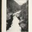
SC 1689385
Oblique aerial view centred on the farmstead, taken from the ENE.
RCAHMS Aerial Photography
16/3/2001
© Crown Copyright: HES

SC 2152061
The Perthshire Estates Estate Exhange, no. 1519 Sales Brochure. Includes details of The Perthshire Estates (Ballyoukan House, Knockdarroch, Killiecrankie House, Coilvoulin Farm, Collerton Farm, Faskally Home farm, Straloch Lodge). Title: 'The Perthshire Estates of Archibald Edward Butter Esq. C.M.G. of Faskally.'
Collection of sale catalogues relating to Scottish estates
15/7/1910
© Courtesy of HES (Estates Exchange Collection)

SC 2152081
The Perthshire Estates Estate Exhange, no. 1519 Sales Brochure. Includes details of The Perthshire Estates (Ballyoukan House, Knockdarroch, Killiecrankie House, Coilvoulin Farm, Collerton Farm, Faskally Home farm, Straloch Lodge). Title: 'The Perthshire Estates of Archibald Edward Butter Esq. C.M.G. of Faskally.'
Collection of sale catalogues relating to Scottish estates
15/7/1910
© Courtesy of HES (Estates Exchange Collection)

SC 2152084
The Perthshire Estates Estate Exhange, no. 1519 Sales Brochure. Includes details of The Perthshire Estates (Ballyoukan House, Knockdarroch, Killiecrankie House, Coilvoulin Farm, Collerton Farm, Faskally Home farm, Straloch Lodge). Title: 'The Perthshire Estates of Archibald Edward Butter Esq. C.M.G. of Faskally.'
Collection of sale catalogues relating to Scottish estates
15/7/1910
© Courtesy of HES (Estates Exchange Collection)

SC 2152085
The Perthshire Estates Estate Exhange, no. 1519 Sales Brochure. Includes details of The Perthshire Estates (Ballyoukan House, Knockdarroch, Killiecrankie House, Coilvoulin Farm, Collerton Farm, Faskally Home farm, Straloch Lodge). Title: 'The Perthshire Estates of Archibald Edward Butter Esq. C.M.G. of Faskally.'
Collection of sale catalogues relating to Scottish estates
15/7/1910
© Courtesy of HES (Estates Exchange Collection)

SC 2152099
The Perthshire Estates Estate Exhange, no. 1519 Sales Brochure. Includes details of The Perthshire Estates (Ballyoukan House, Knockdarroch, Killiecrankie House, Coilvoulin Farm, Collerton Farm, Faskally Home farm, Straloch Lodge). Title: 'The Perthshire Estates of Archibald Edward Butter Esq. C.M.G. of Faskally.'
Collection of sale catalogues relating to Scottish estates
15/7/1910
© Courtesy of HES (Estates Exchange Collection)


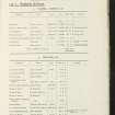


- Council Perth And Kinross
- Parish Fortingall
- Former Region Tayside
- Former District Perth And Kinross
- Former County Perthshire
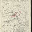
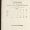
NN74NW 53 74900 47301.
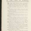
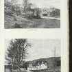
A farmstead comprising four roofed buildings, one with an attached circular pecked line which may indicate a horse-gang, one partially roofed building and two unroofed buildings is depicted on the 1st edition of the OS 6-inch map (Perthshire 1867, sheet xlviii). Five roofed buildings are shown on the current edition of the OS 1:10000 map (1978).
Information from RCAHMS (SAH), 28 October 1997.
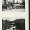
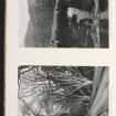
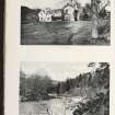
This late-19th-century/early-20th-century farmstead has a U-shaped plan and comprises byres to the ENE (with the stalls intact), stables and a barn with milk house in double pile to the WSW, and a turnip house with a bothy above to the NNW. A cattle-court extension of c.1965 has been built within the yard and there is a detached c.1990 shed to the ENE. A farmhouse lies immediately to the NNW. The farmstead was visited in 2000.
Information from RCAHMS (SS), 14 March 2006.

