|
Photographs and Off-line Digital Images |
C 56184 |
RCAHMS Aerial Photography |
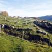
Margcraggan, oblique aerial view taken from the SE, centred on four farmsteads. |
14/5/1996 |
Item Level |
|
|
Photographs and Off-line Digital Images |
C 56186 |
RCAHMS Aerial Photography |
Margcraggan, oblique aerial view taken from the SE, centred on four farmsteads. |
14/5/1996 |
Item Level |
|
 |
On-line Digital Images |
SC 774907 |
Records of the Royal Commission on the Ancient and Historical Monuments of Scotland (RCAHMS), Edinbu |
S farmstead. View of barn (BL00 104) from SE. |
2001 |
Item Level |
|
 |
On-line Digital Images |
SC 774911 |
|
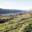
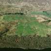
General view of S and central farmsteads from ENE, with Loch Tay in background. |
2001 |
Item Level |
|
 |
On-line Digital Images |
SC 774924 |
|
General view of farmsteads from SSE. |
2001 |
Item Level |
|
 |
On-line Digital Images |
SC 774926 |
Records of the Royal Commission on the Ancient and Historical Monuments of Scotland (RCAHMS), Edinbu |
N farmstead. View of barn (BL00 101) from S. |
2001 |
Item Level |
|
 |
On-line Digital Images |
SC 887149 |
Records of the Royal Commission on the Ancient and Historical Monuments of Scotland (RCAHMS), Edinbu |
S farmstead. Early building platforms (BL00 2009-10) N of byre dwelling (BL00 105). View from WSW. |
2001 |
Item Level |
|
|
Photographs and Off-line Digital Images |
G 88913 CS |
RCAHMS Aerial Photography |
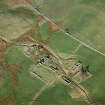
Oblique aerial view of the township of Margdow, taken from the SW. |
18/2/2004 |
Item Level |
|
|
Photographs and Off-line Digital Images |
G 88873 CS |
RCAHMS Aerial Photography |
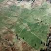
Oblique aerial view of the landscape, field systems and farmsteads on the farm Carie, Lochtayside. Taken from SE. |
18/2/2004 |
Item Level |
|
 |
On-line Digital Images |
SC 904707 |
RCAHMS Aerial Photography |
Oblique aerial view of the township of Margdow, taken from the SW. |
18/2/2004 |
Item Level |
|
 |
On-line Digital Images |
SC 904708 |
RCAHMS Aerial Photography |
Oblique aerial view of the landscape, field systems and farmsteads on the farm Carie, Lochtayside. Taken from SE. |
18/2/2004 |
Item Level |
|
 |
On-line Digital Images |
SC 926208 |
|
Oblique aerial view of ruined farmsteads on Carie farm, centred on former township of Margdow. Taken from SW. |
18/2/2004 |
Item Level |
|
 |
On-line Digital Images |
SC 926220 |
Records of the Royal Commission on the Ancient and Historical Monuments of Scotland (RCAHMS), Edinbu |
S farmstead. N end of barn (BL00 104) showing remains of loft doorway. View from N. |
6/2003 |
Item Level |
|
|
Manuscripts |
MS 731/29 |
Records of the Royal Commission on the Ancient and Historical Monuments of Scotland (RCAHMS), Edinbu |
RCAHMS archaeological field survey database: Ben Lawers 2000. Held as an attribute table in GIS. Please see DX001452 |
2006 |
Item Level |
|
|
Photographs and Off-line Digital Images |
H 94755 CS |
|
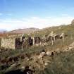
General view of farmsteads from ENE, with Loch Tay in background. |
2001 |
Item Level |
|
|
Photographs and Off-line Digital Images |
H 94756 CS |
|
General view of farmsteads, from E. |
2001 |
Item Level |
|
|
Photographs and Off-line Digital Images |
H 94757 CS |
|
General view of S and central farmsteads from ENE, with Loch Tay in background. |
2001 |
Item Level |
|
|
Photographs and Off-line Digital Images |
H 94758 CS |
|
General view of farmsteads from SSE. |
2001 |
Item Level |
|
|
Photographs and Off-line Digital Images |
H 94759 CS |
Records of the Royal Commission on the Ancient and Historical Monuments of Scotland (RCAHMS), Edinbu |
View of N farmstead (buildings BL00 100-1) from NNW. |
6/2003 |
Item Level |
|
|
Photographs and Off-line Digital Images |
H 94760 CS |
Records of the Royal Commission on the Ancient and Historical Monuments of Scotland (RCAHMS), Edinbu |
N farmstead. View of byre-dwelling (BL00 100) from S. |
2001 |
Item Level |
|
|
Photographs and Off-line Digital Images |
H 94761 CS |
Records of the Royal Commission on the Ancient and Historical Monuments of Scotland (RCAHMS), Edinbu |
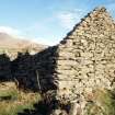
N farmstead. View of byre-dwelling (BL00 100) from SW, showing cruck slot in in wall. |
2001 |
Item Level |
|
|
Photographs and Off-line Digital Images |
H 94762 CS |
Records of the Royal Commission on the Ancient and Historical Monuments of Scotland (RCAHMS), Edinbu |
N farmstead. View of barn (BL00 101) from S. |
2001 |
Item Level |
|
|
Photographs and Off-line Digital Images |
H 94763 CS |
Records of the Royal Commission on the Ancient and Historical Monuments of Scotland (RCAHMS), Edinbu |
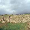
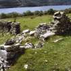
View of the two buildings of the N farmstead (BL00 100-1) from SW, with enclosing wall of farmyard in foreground. . |
6/2003 |
Item Level |
|
|
Photographs and Off-line Digital Images |
H 94764 CS |
Records of the Royal Commission on the Ancient and Historical Monuments of Scotland (RCAHMS), Edinbu |
E end of the byre dwelling (BL00 100) of the N farmstead, with trackway running off to NW. View from E. |
6/2003 |
Item Level |
|


