
Blarmore, Carie


Lairds House (Period Unassigned), Lime Kiln (Period Unassigned), Township (Period Unassigned)
Site Name Blarmore, Carie
Classification Lairds House (Period Unassigned), Lime Kiln (Period Unassigned), Township (Period Unassigned)
Alternative Name(s) House Of Carwhin
Canmore ID 140357
Site Number NN63NE 66
NGR NN 65139 36982
Datum OSGB36 - NGR
Permalink http://canmore.org.uk/site/140357


- Council Perth And Kinross
- Parish Kenmore (Perth And Kinross)
- Former Region Tayside
- Former District Perth And Kinross
- Former County Perthshire
NN63NE 66 65139 36982
A farmstead, comprising three roofed buildings, one unroofed building, one unroofed structure and two enclosures is depicted on the 1st edition of the OS 6-inch map (Perthshire 1867, sheet lxix). One roofed building, two unroofed buildings and one enclosure are shown on the current edition of the OS 1:10000 map (1981).
Information from RCAHMS (AKK) 23 February 1998.
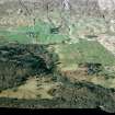
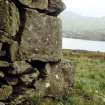
NN 65139 36982 This township stands on a terrace about 750m SSE of Carie farmsteading. Deciduous woodland extends across steeply rising ground to the N and W, while to the SE pasture fields slope more gently towards the N shore of Loch Tay. The remains, which clearly belong to more than one phase of construction, comprise ten buildings (including a fragment of the House of Carwhin, a laird's house or small tower), a limekiln and two enclosures. They are described here clockwise, beginning at the N edge of the township. Three cupmarked stones that have been reused in these structures are described under NN63NE 8.
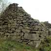
The most substantial structure is a slate-roofed barn (BL00 731) measuring 16.5m from NW to SE by 6.5m transversely over mortared rubble walls. It has opposed entrances at the NW end and two large cart entrances towards the S end of the NE side. Attached to the SW side there is a rectangular enclosure, measuring about 30m by 20m within a drystone dyke. This barn is now used to provide shelter for cattle.
To the E of the barn, in the N corner of the township, there is a group of three buildings which have been laid out to form a small rectangular courtyard, open to the SW. The best-preserved of the three (BL00 733) forms the NW side of the courtyard, and may have been a byre-dwelling. It measures 10.2m from NE to SW by 4.1m transversely within rubble walls 2m in height at the sides and 3.5m in height at the SW gable. One cruck-slot survives in the NW wall. The building has had two entrances on the SE, one of which has been blocked up, and an outshot extends 2.8m to the NE. Cupmarks on two stones used as quoins in the S corner of this building are described under NN63NE 8. The second building (BL00 735) stands immediately to the E and at right angles to the first. Its SW side has been incorporated into a drystone dyke and its other walls are reduced to low stony banks, but it has measured 19m by 6.5m overall and it appears to have been divided into two compartments. The third building of this group (BL00 734), which forms the SE side of the courtyard, has been reduced to little more than a platform measuring overall 13.6m by 4.8m; only the NE gable remains standing, 1.5m high.
To the S of this group, the fifth and sixth buildings form two parallel ranges, each lying NE and SW. That to the N (BL00 736), which stands at the centre of the township, is the larger of the two. It measures about 40m by 5m over the fragmentary remains of walls up to 0.6m in height. On the date of visit dense vegetation, including mature trees, obscured the interior, but it was clear that the central portion of the range has been rebuilt; this secondary structure measures 4.2m by 4m within walls 1.5m in height, and has an entrance on the SE. Attached to the NW side of this range there is a subrectangular enclosure, measuring at least 35m by 13m within a stony bank which incorporates the third cupmarked stone mentioned above (see NN63NE 8). The range to the S (BL00 739) lies along the SE edge of the township. Its walls have been robbed to their footings, except for the SE side, which has been incorporated into a later field dyke. It measures overall 32.5m by 4.6m, and appears to have been divided into three compartments. About 10m to the SW there is another building (BL00 737) on the line of the field dyke. It measures 9.5m from NE to SW by 3.9m transversely within rubble walls 1.1m in height, and the interior is filled with rubble.
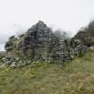
The eighth building (BL00 738) stands to the W of that just described, and close to the S corner of the township. It measures 16.5m from NE to SW by 3.8m transversely within rubble walls up to 1.7m in height at the sides, and an outshot extends 4m to the SW. The gables survive to their full height, approximately 3.5m. Originally, the building appears to have had three entrances in the SE wall, but the central entrance has been blocked. The occasion for the blocking may have been the insertion of a partition wall, whose SW face is flush with the NE jamb of the blocked entrance. This partition has a central fireplace and an aumbry facing into the larger SW compartment of the building, while a doorway links the two compartments. There is a window towards the W end of SE side, and other windows may have been lost in the collapse of the side walls. There are also traces of a pair of opposed cruck-slots in the NE compartment. This building is likely to have been constructed as a byre-dwelling, the byre being at the NE end, though no evidence of a byre-drain was observed. The most interesting aspect of the building, however, is the NE gable, which incorporates a fragment of an earlier, ninth, building, constructed of dressed masonry set in a clay mortar, in contrast to the undressed rubble of the rest of the building. This wall fragment, which measures about 1.5m in thickness and stands to more than 2.5m in height, includes the quoins of the S corner of the earlier building, as well as the remnants of a substantial fireplace. The fireplace faces NE, so the earlier building must have stood to the NE of the byre-dwelling, but its plan could not be traced with any certainty.
The tenth building stood about 35m to the NW, to the SW of the enclosure attached to the roofed barn. Its NE end was obscured by vegetation on the date of visit, but it has measured at least 9.5m by 4.5m overall. Finally, the limekiln (BL00 732) stands 20m W of the barn. It measures 3.2m in diameter within a stony bank 2m in thickness. Although the bowl is filled with rubble it appears to have measured about 2m in depth. The draw-hole is on the SSE.
The quality of the masonry in the surviving fragment of the ninth building described above indicates that it was a structure of some status; in all probability this was the House of Carwhin, recorded in the Breadalbane Estate papers in 1676, and again in 1686, when an inventory was made of its contents. In 1707 payment is recorded for 'tirring the house of Carchun', that is, for dismantling it or at least removing its roof (see John Harrison's 2003 report on Ben Lawers, RCAHMS MS1155/6, pp.82-3). John Farquharson's 1769 Survey of the North Side of Loch Tay (National Archives of Scotland, RHP 973/1, Plan 8) names this settlement Carawhin, and depicts nine buildings, with what appears to be a large formal garden to the SE. The disposition of Farquharson's buildings is generally similar to that of the structures described above, though he does not identify any of them as a house of any particular significance. The 1st edition of the OS 6-inch map (Perthshire 1867, sheet lxix) shows three roofed buildings (BL00 731, 733 and 738), one unroofed building (BL00 737), the limekiln, the two enclosures and two small roofless structures, possibly pens, adjacent to the barn (BL00 731). By then the site was known as Blarmore, a name that had been applied by Farquharson to a settlement about 1km to the WNW (see NN63NW 87). The 2nd edition of the OS map (Perthshire 1900, sheet lxix NW) depicts the same three roofed buildings and the two enclosures. It also shows as roofless the rebuilt central section of one of the long ranges (BL00 736).
(BL00 731-9, 2546)
Visited by RCAHMS (SPH and MFTR) 30 November 2000
The first excavation season of the Ben Lawers Historic Landscape Project was undertaken in September 2002 as a National Trust for Scotland Thistle Camp. The programme of work focused on the land division previously known as Easter Carawhin, and was targeted at three settlement locations previously surveyed in March 2002.
Blarmore. Excavation targeted the remains of a possible lairds house; the laird is recorded as having lived here in the 16th century. A trench was opened adjacent to a standing gable, which incorporates the remains of a large fireplace and which was reused as the gable for a later building. The excavation found a collapsed opposite gable wall that had been robbed of facing stones and reused, possibly as a stack stance. This sealed a destruction layer containing numerous pieces of wallplaster and perforated slate, which in turnsealed a series of cuts for horizontal timber beans to support a plank floor. Chocking stones for a hearth slab were also found. The excavation confirmed the presence here of a high-status building with a large fireplace, a timber floor, plastered interior walls and a pegged slate roof. No definitive evidence was found that this was a tower house, but the absence of 17th- to 18th-century artefactual material suggests the building went out of use and was robbed for its stone, timber and slate before that time.
J A Atkinson, J S Duncan, O Lelong and G MacGregor 2002

