
Pricing Change
New pricing for orders of material from this site will come into place shortly. Charges for supply of digital images, digitisation on demand, prints and licensing will be altered.
Flotta, Housegeo


Farmstead (Period Unassigned), Naust(S) (Period Unassigned)
Site Name Flotta, Housegeo
Classification Farmstead (Period Unassigned), Naust(S) (Period Unassigned)
Canmore ID 138669
Site Number ND39SE 42
NGR ND 37195 92633
NGR Description Centred ND 37195 92633
Datum OSGB36 - NGR
Permalink http://canmore.org.uk/site/138669


- Council Orkney Islands
- Parish Walls And Flotta
- Former Region Orkney Islands Area
- Former District Orkney
- Former County Orkney
ND39SE 42 centred 37195 92533
Orkney SMR Reference: OR 2637
For the well previously recorded under this number, refer to ND39SE 72.
(Centred 3712 9267)
ND 370 926 Occupied croft, noosts and clearway (intertidal zone).
Sponsors: Historic Scoland, Orkney Archaeological Trust.
G Wilson and H Moore 1997.
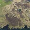
The upstanding remains of the farmhouse (at ND 37195 92533 and outbuilding are visible on oblique aerial views taken in 2008 (RCAHMSAP 2008), situated about 154m WNW of the Port War Signal Station (ND39SE 35). Visible is the unroofed farmhouse and outhouses within one of the fields attached to the 'croft'.
The farmstead is depicted as roofed on the 1st Edition of the OS 6-inch map (Orkney, 1882, sheet cxix), which shows an L-shaped in plan building with an outhouse. The two fields attached to the 'croft' are measured as (from 1st Edition OS 25-inch) as c.0.60 and c.0.95 hectares with a small garden, which is just visible on the air views to the W of the house, at approximately 0.02 hectares. The well noted above (nd39se 72) is at c.ND 3713 9265.
The Object Name Book of the Ordnance Survey (ONB) describes the farmstead as'A small farm house situated on the east side of Kirk Bay and immediately south of "Little Bow". Proprietor The Earl of Zetland' (Name Book).
Information from RCAHMS (DE), February 2009
Orkney Smr Note (1997)
Two shallow sub-rectangular depressions at head of foreshore currently used as boat noosts.
Slipway
Moore and Wilson 1997, p207
Information from Orkney SMR, 1997

