
Pricing Change
New pricing for orders of material from this site will come into place shortly. Charges for supply of digital images, digitisation on demand, prints and licensing will be altered.
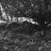
Ardvannie


Chambered Cairn (Neolithic)
Site Name Ardvannie
Classification Chambered Cairn (Neolithic)
Canmore ID 13859
Site Number NH68NE 7
NGR NH 68240 87401
Datum OSGB36 - NGR
Permalink http://canmore.org.uk/site/13859


- Council Highland
- Parish Edderton
- Former Region Highland
- Former District Ross And Cromarty
- Former County Ross And Cromarty
NH68NE 7 6823 8740
(NH 6812 8740) Cairn (NR) (Remains of)
OS 25" map, (1970)
Round cairn of bare stones with a diameter of 70ft and height of 3ft after partial robbing. The tops of the slabs of the polygonal chamber can be seen a little to the E of the centre of the cairn. Orkney-Cromarty type.
V G Childe 1944; A S Henshall 1963, visited 1956.
The remains of this chambered cairn are as described by Miss Henshall. It appears to have had a diameter of some 26m and a maximum height of 1.6m. The E edge of the cairn has been cut by an access road. The top of the cairn has been partly cleared and the remains of a chamber are outlined by five upright slabs, largest 0.6m in height, and two large falled slabs.
Resurveyed at 1:2500.
Visited by OS (W D J) 15 May 1963.
(NH 6823 8740) Chambered Cairn (NR)
OS 25" map, (1970).
This chambered cairn, in moderate condition, is as described by the previous OS field investigator.
Visited by OS (J B) 23 February 1981.
Field Visit (9 September 1943)
This cairn stands on the edge of a small wood immediately west of the farm road and less than 100 yards north of the main road from Edderton to Bonar Bridge. The site is on rolling glacial country just below the 100’ contour at the foot of Suie Hill, the land across the farm road being cultivated today. The cairn has been much disturbed and farm road actually encroaches on its eastern margin. It seems however to measure about 67’ from east to west and 73’ from north to south, and rises at the highest point about 5’ above the level of the road on the east. Close to the centre are exposed six slabs belonging to a polygonal chamber, but the space between them has been filled up again to varying levels with rounded boulders from the surrounding cairn.
The heights of the stones are all given from a common base that in most cases had to be calculated and that may well be more than 3’ above the floor of the chamber. The chamber was probably 11’ east to west and 6’ wide and entered by a passage on the east, no longer visible. The headstone (D) is situated at almost the centre of the cairn: it is pointed at the top and rises 1’3” above our arbitrary base where it is 2’9” wide and 8” thick, its sides seeming to run down vertically below this. In the south side there are 2 stones in situ – E rising to a point 4’ above our base (6’ above the road surface) and expanding to a width of at least 3’8” with a thickness of 1’9”, and F square-topped 3’3” above our base, 3’8” long and 1’9” thick. In the north side stone C is leaning outwards at an angle of 42 degrees to the vertical, its exposed length being 2’8”. Assuming its total height was 5’ its base would be in the position shown by a dotted outline in the plan. Only the upper edges of stones B and C are exposed, but, from our base, B should be 1’5” high; it is 1’ thick at its west end and 1’8” at the east. Finally stone A of the same height is 3’3” wide on the east and 2’ thick; it resembles a portal jamb rather than a side slab.
Between the east end of this chamber and the road a large block that might have been a lintel or an orthostat is lying on the surface of the cairn. Otherwise this consists entirely of boulders.
xxvii. (‘Cairn, remains of’)
Visited by RCAHMS (VGC, AG) 9 September 1943
Notes and sketch plan in MS 36 collection.
Field Visit (November 1977)
Ardvannie (ROS 2) NH 682 874 NH68NE 7
This Orkney-Cromarty Cairn measures 21m in diameter and 0.9m in height. A polygonal chamber lies to the E of the centre of the cairn.
RCAHMS 1979, visited November 1977.
(Henshall, i, 333, 335)
Watching Brief (2001)
NH 683 875. A watching brief was undertaken on the site of a proposed agricultural building affecting the setting of a chambered cairn (NMRS NH68NE 7). No archaeological features or artefacts were noted.
Sponsor: Ms Ruth Clayton.
C A Miller 2001.

