Pricing Change
New pricing for orders of material from this site will come into place shortly. Charges for supply of digital images, digitisation on demand, prints and licensing will be altered.
Ardvannie
Cremation Cemetery (Prehistoric)(Possible), Enclosure (Prehistoric), Mound (Prehistoric)
Site Name Ardvannie
Classification Cremation Cemetery (Prehistoric)(Possible), Enclosure (Prehistoric), Mound (Prehistoric)
Canmore ID 13818
Site Number NH68NE 19
NGR NH 68559 87548
Datum OSGB36 - NGR
Permalink http://canmore.org.uk/site/13818
- Council Highland
- Parish Edderton
- Former Region Highland
- Former District Ross And Cromarty
- Former County Ross And Cromarty
NH68NE 19 6856 8754
(NH 6856 8754) Enclosure (NR)
OS 25" map, (1970)
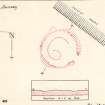
On level ground on the brink of a raised beach is a probable funerary enclosure (OS [WDJ]). It consists of a circular stony bank spread to about 2.0m which is revetted internally by a discontinuous line of earth-fast stones giving an internal diameter of 17.9m. The bank is mutilated, particularly in the NW and a break in the SE, about 3.0m wide, also appears to be a mutilation. Within the bank is a ditch about 0.2m deep, about 3.5m wide, surrounding a circular platform, about 11.0m in diameter, which is destroyed in the SE and shows signs of having been quarried elsewhere. On the SW quadrant of the platform is an amorphous mound about 0.5m high.
The true nature of this site is uncertain. It may be a hengiform earthwork, but the mutilationsin the SE have destroyed any evidence of an entrance or causeway. It is more likely to be a Wessex-type cairn, the break in the bank in the SE being to facilitate robbing.
Visited by OS (W D J) 8 May 1963 and (R L) 28 October 1963.
Field Visit (October 1978)
Ardvannie2 NH685875 NH68NE 19
Situated about 200m WNW of Ardvannie farmhouse there is a mutilated enclosure 11m in diameter within a stony bank. Eccentrically placed within the enclosure there is a turf covered mound.
RCAHMS 1979, visited October 1978


