
Wester Lealty


Hut Circle(S) (Prehistoric)
Site Name Wester Lealty
Classification Hut Circle(S) (Prehistoric)
Canmore ID 13784
Site Number NH67SW 20
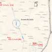
NGR NH 6018 7281
NGR Description NH 60136 72818 and NH 60220 72593
Datum OSGB36 - NGR
Permalink http://canmore.org.uk/site/13784


- Council Highland
- Parish Alness
- Former Region Highland
- Former District Ross And Cromarty
- Former County Ross And Cromarty
NH67SW 20 6015 7282 and 6023 7260.
Centred at NH 601 726 on the NE-facing slopes of Cnoc na Moine are two circular stone-walled huts within an area of stone clearance heaps probably contemporary but peat growth has obscured evidence of fields. The hut at NH 6015 7282, measures c.9.5m in diameter between the centres of a mutilated wall spread to c.2.0m in the S where it is best preserved, and evident as a stony scarp elsewhere. An earthfast boulder marks the course of the wall in the NE, and a possible outer wall facing stone is visible in the SE. The ill-defined entrance is in the E. The hut at NH 6023 7260 measures c.7.5m in diameter between the centres of a wall spread to c. 2.0m all round. The entrance is not evident.
Visited by OS (A A) 4 November 1970.
Surveyed at 1/2500.
Visited by OS (I S S) 23 August 1972.
Field Visit (September 1978)
Wester Lealty NH 601 726 NH67SW 20
Two hut-circles measuring respectively 7.5m and 9.5m between wall-centres are visible in a group of small cairns which have been partly overgrown by peat.
RCAHMS 1979, visited September 1978

