
Following the launch of trove.scot in February 2025 we are now planning the retiral of some of our webservices. Canmore will be switched off on 24th June 2025. Information about the closure can be found on the HES website: Retiral of HES web services | Historic Environment Scotland
Dumfries - Stranraer Railway, Kirkgunzeon Lane Viaduct


Railway Viaduct (19th Century)
Site Name Dumfries - Stranraer Railway, Kirkgunzeon Lane Viaduct
Classification Railway Viaduct (19th Century)
Alternative Name(s) 'Port Road'; Royal Naval Armaments Depot, Nitro-glycerine Works; Edingham Munitions Factory
Canmore ID 137555
Site Number NX86SW 39.02
NGR NX 84877 62923
NGR Description From NX 84854 62908 to NX 84892 62934
Datum OSGB36 - NGR
Permalink http://canmore.org.uk/site/137555


- Council Dumfries And Galloway
- Parish Urr
- Former Region Dumfries And Galloway
- Former District Stewartry
- Former County Kirkcudbrightshire
NX86SW 39.02 84854 62908 to 84892 62934
Kirkgunzeon Lane Viaduct [NAT]
OS 1:10,000 map, 1982.
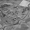
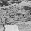
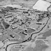
Scheduled with Edingham Munitions Factory, for which see NX86SW 36.
Information from Historic Scotland, scheduling document dated 5 October 1998.
This viaduct formerly carried the Dumfries - Stranraer 'Port Road' of the former Glasgow and South-Western Rly over the Kirkgunzeon Lane, which here forms the boundary between the parishes of Urr and Kirkgunzeon.
Information from RCAHMS (RJCM), 2 December 1998.
The viaduct was also part of the boundary between the Royal Naval Munitions factory and the surrounding farmland. The W parapet supports a line of steel boundary posts, the wire having been removed.
Visited by RCAHMS (DE), 22 August 2006

