
Lewis, Ceann A' Gharaodh


Building (Period Unassigned), Farmstead (Period Unassigned), Lazy Beds (Post Medieval)
Site Name Lewis, Ceann A' Gharaodh
Classification Building (Period Unassigned), Farmstead (Period Unassigned), Lazy Beds (Post Medieval)
Canmore ID 137376
Site Number NB23SW 53
NGR NB 2215 3248
Datum OSGB36 - NGR
Permalink http://canmore.org.uk/site/137376


- Council Western Isles
- Parish Uig
- Former Region Western Isles Islands Area
- Former District Western Isles
- Former County Ross And Cromarty
NB23SW 53 2215 3248
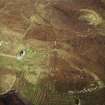
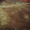
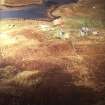
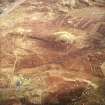
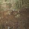
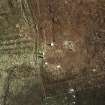
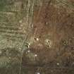
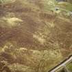
A farmstead, comprising one unroofed building is depicted on the 1st edition of the OS 6-inch map (Island of Lewis, Ross-shire 1853, sheet 25). One unroofed building and three enclosures are shown on the current edition of the OS 1:10000 map (1974).
Information from RCAHMS (AKK) 29 September 1997.
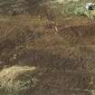
The remains of lazy beds have been recorded on oblique aerial photography (RCAHMSAP 2004) extending to the N of the farmstead. A modern building lies within the area of the lazy beds, immediately to the N of the farmstead.
Information from RCAHMS (KMM) 18 May 2005

