
Kinrive


Enclosure (Prehistoric), Hut Circle (Prehistoric)
Site Name Kinrive
Classification Enclosure (Prehistoric), Hut Circle (Prehistoric)
Canmore ID 13728
Site Number NH67NE 6
NGR NH 69932 75473
Datum OSGB36 - NGR
Permalink http://canmore.org.uk/site/13728


- Council Highland
- Parish Kilmuir Easter
- Former Region Highland
- Former District Ross And Cromarty
- Former County Ross And Cromarty
NH67NE 6 6993 7547.
(NH 6993 7547) Hut Circle (NR)
OS 6" map, (1969)
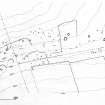
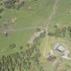
In cleared woodland on a SE-facing slope is a circular stone-walled hut, measuring c.10.0m in diameter between the centres of a denuded wall spread to c.2.0m, but destroyed in the W arc. The outer wall face of stones set on edge is visible in the S and E arcs. The "simple" entrance is in the ESE. A stony bank c.2.0m wide curves W from the WNW arc of the hut, and can be traced intermittently towards the SE. It is part of the NW side of a sub-rectangular enclosure c.70.0m NW-SE by c.50.0m. The SW corner abuts onto the NE end of a long cairn (NH67NE 2). A few clearance heaps occur near the hut, possibly from contemporary plots.
Surveyed at 1/2500 (OS [RDL]).
Visited by OS (R D L) 13 May 1963 and (N K B) 26 October 1970.
An irregularly shaped enclosure is depicted on the 1st edition of the OS 6-inch map (Ross-shire and Cromartyshire 1880, sheet liv). A hut circle with an attached short length of wall is annotated and depicted on the current edition of the OS 1:10000 map (1985).
Information from RCAHMS (SAH) 10 April 1996
Field Visit (November 1977)
Kinrive 2 NH 699 754 NH67NE 6
What may be a hut-circle stands among small cairns in an area of cleared woodland 250m NNW of Mid Kinrive. It measures 10m in diameter within a wall 2m in thickness with an entrance on the ESE. A sub-rectangular enclosure which abuts on the SE appears to be of no great age.
RCAHMS 1979, visited November 1977
Measured Survey (1979)
The unenclosed settlement, field system and long cairns at Kinrive were surveyed at a scale of 1:1000.
Visited by RCAHMS (AL, SS) 1979

