
Lewis, Garenin, 25


Building(S) (Period Unassigned), Enclosure(S) (Period Unassigned)
Site Name Lewis, Garenin, 25
Classification Building(S) (Period Unassigned), Enclosure(S) (Period Unassigned)
Canmore ID 137102
Site Number NB14SE 9.02
NGR NB 1972 4384
Datum OSGB36 - NGR
Permalink http://canmore.org.uk/site/137102


- Council Western Isles
- Parish Uig
- Former Region Western Isles Islands Area
- Former District Western Isles
- Former County Ross And Cromarty
Note
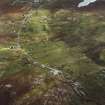
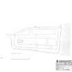
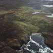
One roofed building and five enclosures are depicted on the 1st edition of the OS 6-inch map (Island of Lewis, Ross-shire 1853, sheet 12) and may form a second foci of the township.
Five unroofed buildings and five enclosures are shown on the current edition of the OS 1:10000 map (1974).
Information from RCAHMS (AKK) 18 September 1997.

