
Castlecraig


Tower (Medieval)
Site Name Castlecraig
Classification Tower (Medieval)
Alternative Name(s) Castle Craig; Craig Castle
Canmore ID 13702
Site Number NH66SW 2
NGR NH 63200 63813
Datum OSGB36 - NGR
Permalink http://canmore.org.uk/site/13702


- Council Highland
- Parish Resolis
- Former Region Highland
- Former District Ross And Cromarty
- Former County Ross And Cromarty
NH66SW 2 63200 63813
For carved stone (part of gunloop) at NH 6319 6382, see NH66SW 43.
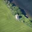
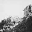
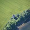
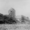
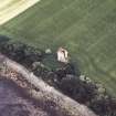
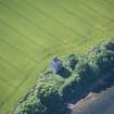
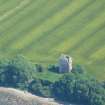
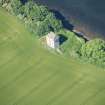
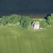
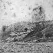
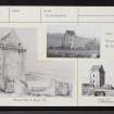
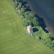
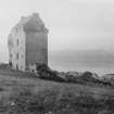
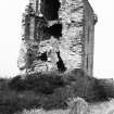
The remains of Craig Castle, a late 16th-century tower, comprise the roofed NE wing, which has vaulted floors and a corbelled parapet; a wing which probably extended to the NW, and a stairway in the re-entrant angle, have fallen to ruin. There is an enclosure to the N and what may be an oven to the E. Parts of the enclosure may be of earlier date, but the traditional association with the bishops of Ross may well relate to the use of the site as an occasional episcopal residence in the post- Reformation period.
Orig Paroch Scot 1855; D MacGibbon and T Ross 1887-92; RCAHMS 1979; G Stell 1986.
Tower House.
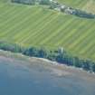
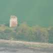
Severly eroded coastal undercutting at High Water Mark.
Late 16th century.
CFA/MORA Coastal Assessment Survey 1998.
Field Visit (June 1979)
Craig Castle NH 631 638 NH66SW 2
This commodious tower-house was built in the late 16th or early 17th century, traditionally by the Urquhart family, Barons of Cromarty; it was later occupied by the Bishops of Ross. The roofed NE wing has vaulted floors and a corbelled parapet; a wing which probably extended to the NW, and a stairway in the re-entrant angle, have fallen to ruin. There is a courtyard to the N and what may be an oven to the E.
RCAHMS 1979, visited June 1979
MacGibbon and Ross 1887-92, iii, 465-7
Field Visit (2013 - 2014)
Severely eroded with coastal undercutting at HWM. There is a curtain wall 20 metres north of the tower house - ie to seaward - that sits on a near vertical crag of sandstone. The base of the crag is being undercut at the HWM. The curtain wall is heavily covered in ivy. The tower-house is relatively intact on 3 sides but has lost its west wall and is open on that side.
Visited by Scotland's Coastal Heritage at Risk (SCHARP) 2013

