
Pricing Change
New pricing for orders of material from this site will come into place shortly. Charges for supply of digital images, digitisation on demand, prints and licensing will be altered.
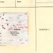
Wester Brae


Long Cairn (Neolithic)
Site Name Wester Brae
Classification Long Cairn (Neolithic)
Canmore ID 13692
Site Number NH66SE 6
NGR NH 65650 61397
Datum OSGB36 - NGR
Permalink http://canmore.org.uk/site/13692


- Council Highland
- Parish Resolis
- Former Region Highland
- Former District Ross And Cromarty
- Former County Ross And Cromarty
NH66SE 6 6564 6139.
(NH 6564 6139) Cairn (NR)
OS 6" map, (1959)
This long cairn, oriented ENE-WSW is 85' long and about 38' wide at the west end and 48' at the east end. It is composed of rounded stones overgrown with moss and turf. A depression near the centre suggests that there has been some robbing, but the ends appear to be intact, the west being 6' high and the east 5' high.
The cairn stands within the area of a field of small cairns (NH66SE 7).
A S Henshall 1963.
A wedge-shaped long cairn, in good condition, as described by Henshall, situated in dense afforestation.
Resurveyed at 1/2500.
Visited by OS (N K B) 27 January 1966.
No change to previous field report.
Surveyed at 1:10 000.
Visited by OS (J B) 11 January 1978.
Field Visit (26 August 1943)
On the SE flank of the ridge but still rather above the 550ft contour, nearly ¾ mile SSW of the Mid Brae cairn [Canmore ID 13690] but hidden therefrom by the slope of the ridge and 700 yds SSE of Wester Brae, is along cairn. It stands in a young plantation of the Forestry Commission but its not itself planted and has not been traversed by the plough but is much overgrown with heather, whins and raspberries. The cairn is about 85ft [25.9m] long ENE to WSW (axis c. 60deg E of N), about 48ft [14.6m] wide near the E end and 38ft [11.6m] wide near the W end, and over 5 ft [1.5m] high near the broader end. A hole has been dug into the cairn 21ft [6.4m] from the E end and a larger one from the S side 20ft [6m] further along the axis. These operations have exposed closely packed, large boulders but no sort of chamber. Other large boulders can be seen among the heather on the flanks of the mound.
Visited by RCAHMS (AG) 26 August 1943
OS 6” map (1907) ‘Tumulus’
Field Visit (May 1979)
Wester Brae (ROS 39) NH 656 613 NH66SE 6
This long cairn stands in dense forest 1 km ENE of Woodhead farmhouse; it measures 26m from ENE to WSW by 15m at the broader (ENE) end and up to 2.5m in height. On the S it has been disturbed by the construction of a forestry track.
RCAHMS 1979, visited May 1979
Woodham 1956, 78, no. 33; Henshall 1963-72, i, 356; ii, 565

