
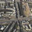
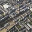
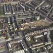
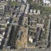
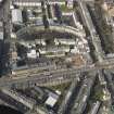
Edinburgh, Mcdonald Road, General


General View (Period Unassigned)
Site Name Edinburgh, Mcdonald Road, General
Classification General View (Period Unassigned)
Canmore ID 136829
Site Number NT27NE 176
NGR NT 26229 75049
NGR Description Centred NT 2622 7504
Datum OSGB36 - NGR
Permalink http://canmore.org.uk/site/136829


- Council Edinburgh, City Of
- Parish Edinburgh (Edinburgh, City Of)
- Former Region Lothian
- Former District City Of Edinburgh
- Former County Midlothian
NT27NE 176 centred 2622 7504
NMRS REFERENCE:
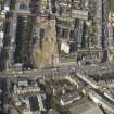
NMRS Print room: Inglis Photograph Collection Acc No 199/90
OS First edition with the North West end of McDonald Road and Bellevue Road drawn on, photograph 1930s or 1940s (2 prints)
Drawings IGL 1950/7/1/1-3 are for McDonald Road, St James's Church. Two unnamed churches appear in McDonald Road on the 4th edition of the OS 1:2500 map (1931) at NT 2605 7521 and at NT 2632 7498.
Information from RCAHMS (DJNP), 11 May 2004.

