
Baillieknowe


Chimney (Period Unassigned), Farmstead (Period Unassigned)
Site Name Baillieknowe
Classification Chimney (Period Unassigned), Farmstead (Period Unassigned)
Canmore ID 136620
Site Number NT73NW 42
NGR NT 71230 38170
NGR Description centred 71230 38170
Datum OSGB36 - NGR
Permalink http://canmore.org.uk/site/136620


- Council Scottish Borders, The
- Parish Stichill
- Former Region Borders
- Former District Roxburgh
- Former County Roxburghshire
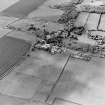
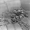
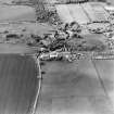
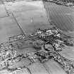
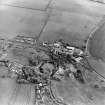
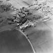
The farm of Ballieknowe lies at the edge of the village of Stichill. Most of the farm buildings, which are constructed of rubble, probably date from the mid-nineteenth century, a period when many rural improvements were made.
The second edition of the Ordnance Survey 6-inch map (1899) shows a path leading from the farm to a row of cottages. Farming at this time was very labour-intensive, so landowners had to provide accommodation for their workers.
Text prepared by RCAHMS as part of the Accessing Scotland's Past project
NT73NW 42.00 71230 38170.
This farmstead is undergoing survey as part of the Scottish Farm Buildings Survey: Lothian and Merse. Survey information to follow.
Information from RCAHMS (GPS) 24 November 1998.
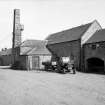
This extensive complex lies adjacent to the NW of the farmhouse. In part it consists of three ranges that enclose two SE-facing cattle courts. A stable range with loft over is situated in front of these. There are also various other ranges and detached buildings, one of which includes a stone-built chimney stack. The farmstead is built of rubble and has slate roofs. When visited in 1997 it was in agricultural use.
Information from RCAHMS (SS), 14 February 2006.
Related site:
NT73NW 42.01 Baillieknowe chimney.

