
Pricing Change
New pricing for orders of material from this site will come into place shortly. Charges for supply of digital images, digitisation on demand, prints and licensing will be altered.
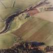
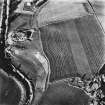
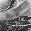
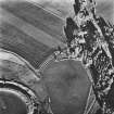
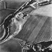
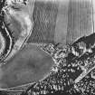
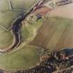
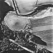
Heughhead


Farmstead (Period Unassigned), Mill (Period Unassigned)(Possible)
Site Name Heughhead
Classification Farmstead (Period Unassigned), Mill (Period Unassigned)(Possible)
Alternative Name(s) Heugh-head
Canmore ID 136569
Site Number NJ50SW 28
NGR NJ 5151 0210
Datum OSGB36 - NGR
Permalink http://canmore.org.uk/site/136569


- Council Aberdeenshire
- Parish Coull
- Former Region Grampian
- Former District Kincardine And Deeside
- Former County Aberdeenshire
NJ50SW 28 5151 0210
A farmstead comprising one unroofed building, one partially roofed L-shaped building, two roofed buildings, one of which is arranged around a courtyard and lies adjacent to a burn which is annotated Sluice and may therefore be a mill, and two enclosures is depicted on the 1st edition of the OS 6-inch map (Aberdeenshire 1870, sheet lxxxii). Five enclosures are shown on the current edition of the OS 1:10000 map (1972).
Information from RCAHMS (SAH) 27 April 1999.

