
Pricing Change
New pricing for orders of material from this site will come into place shortly. Charges for supply of digital images, digitisation on demand, prints and licensing will be altered.
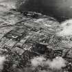
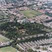
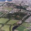
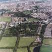
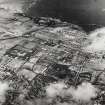
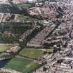
Edinburgh, Stockbridge, Glenogle Road, Stockbridge Colonies, General


General View (Period Unassigned)
Site Name Edinburgh, Stockbridge, Glenogle Road, Stockbridge Colonies, General
Classification General View (Period Unassigned)
Canmore ID 135963
Site Number NT27SW 1339
NGR NT 24640 74952
NGR Description Centred NT 24640 74952
Datum OSGB36 - NGR
Permalink http://canmore.org.uk/site/135963


- Council Edinburgh, City Of
- Parish Edinburgh (Edinburgh, City Of)
- Former Region Lothian
- Former District City Of Edinburgh
- Former County Midlothian
NT27SW 1339 24640 74952 (Centred)
Built by Edinburgh Co-operative Building Company 1861.
Photographic Survey (1 March 2009 - 16 September 2009)
Advance works for the Water of Leith Flood Prevention Scheme included a photographic survey of various buildings along the Water of Leith, to record their baseline condition, and a watching brief during the relocation of services on Warriston Road, Edinburgh. Buildings photographed included : Bridges; Weirs; the view of the Longstone Inn; the view of the 19th century mining village at Longstone; the view of the colonies at Stockbridge; the Coltbridge mill lade where it survives between the Edinburgh Sports Club and the Dean Gallery. The watching brief (http://canmore.org.uk/event/999897) uncovered a cobbled surface which overlay a concrete raft. Disturbance from a network of underground services between the current ground surface and the limit of excavation rendered the preservation of in situ archaeological remains as highly unlikely. Further evidence of ground disturbance / make up was the mixed sequence of made-ground or service trench backfill which formed the bulk of the recorded deposits during the watching brief. All the above activity is interpreted as 19th to 20th century evidence of infrastructure improvements.
Information from Michael Stuart (CFA Archaeology Ltd) June 2009. OASIS ID - cfaarcha1-135247

