
Buckhood


Building(S) (Post Medieval), Enclosure(S) (Post Medieval)
Site Name Buckhood
Classification Building(S) (Post Medieval), Enclosure(S) (Post Medieval)
Canmore ID 135899
Site Number NO36SW 31
NGR NO 3496 6360
Datum OSGB36 - NGR
Permalink http://canmore.org.uk/site/135899


- Council Angus
- Parish Cortachy And Clova
- Former Region Tayside
- Former District Angus
- Former County Angus
NO36SW 31 3496 6360
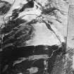
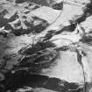
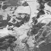
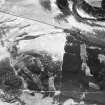
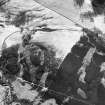
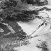
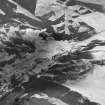
Twelve buildings, situated on the ridge between Glen Prosen and Glen Cally, were recorded by Headland Archaeology during a survey of the Balnaboth Estate (NMRS MS 899/87, no.44). The buildings range in size from 7m to 16m in length by 3m to 4m and are defined by turf-covered stony banks spread up to 2m in width standing up to 0.7m high. The buildings are all single-roomed and generally subrectangular in plan although two are oval shaped (NMRS MS 899/87, nos.44.1 and 44.5). Two buildings (NMRS MS 899/87, nos.44.3 and 44.8) have traces of small yards or enclosures attached whilst building (NMRS MS 899/87, no.44.9) has a subrectangular enclosure, measuring between 7m to 12m by 15m within turf-covered stony banks spread to 1.5m in width and 0.3m high. Both this building and enclosure are depicted, unroofed, on the 1st edition of the OS 6-inch map (Forfarshire, 1865, sheet xxiv) although none of the other structures are shown. A field boundary to the N may also correspond to a boundary depicted on the 1st edition map. One of the oval buildings (NMRS MS 899/87, no.44.1) is cut into the this bank.
M Dalland and S Carter (Headland Archaeology) July 1998; NMRS MS 899/87, no.44

