
South Uist, Ormiclate


Cottage(S) (19th Century), Farmhouse (19th Century), Farmstead (19th Century)
Site Name South Uist, Ormiclate
Classification Cottage(S) (19th Century), Farmhouse (19th Century), Farmstead (19th Century)
Alternative Name(s) Ormaclett
Canmore ID 135870
Site Number NF73SW 13
NGR NF 74046 31856
Datum OSGB36 - NGR
Permalink http://canmore.org.uk/site/135870


- Council Western Isles
- Parish South Uist
- Former Region Western Isles Islands Area
- Former District Western Isles
- Former County Inverness-shire
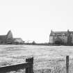
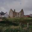
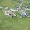
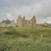
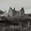
Ormiclate Farmhouse, late 18th/early 19th century Harled and slated farmhouse of 'improved' type, forming part of the west range enclosing the forecourt to Ormiclate Castle. Miss Margaret Macdonald, sister of young Clanranald of the '45, was living here when she died in 1826 aged 88 - the last of her family to be associated with Ormiclate. Relegated to a grieve's house in the late 19th century, it was restored in 1996.
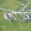
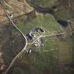
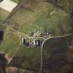
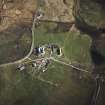
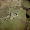
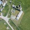
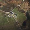
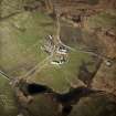
The Square, c.1877 Fairly standard court of improved steadings and farmworkers' houses, built to plans used for farm buildings on the Gordon's Cluny estate in Aberdeenshire.
Taken from "Western Seaboard: An Illustrated Architectural Guide", by Mary Miers, 2008. Published by the Rutland Press http://www.rias.org.uk

NF73SW 13 74032 31854.
Not to be confused with Ormaclett (or Ormiclate) Castle at NF 7399 3180, for which see NF73SW 1.
This 19th-century steading is undergoing survey as part of the Scottish Farm Buildings Survey. Information to follow.
Information from RCAHMS (GPS), 11 November 1998.
This courtyard farmstead includes two pairs of two-storeyed and gabled cottages, the one to the N and the other to the S. These pairs are linked to each other by ranges of byres to the W and E with grain storage above. Stalls remain in the byres in the W range. There is an arched and gabled entry in the centre of the E byre range bearing a date stone of 1877. The buildings are of harled and pointed coursed stone with dressed quoins and mainly have slated roofs but with some use of corrugated materials. There is a detached implement shed. The farmstead was mostly derelict when visited in 1998.
Information from RCAHMS (SS), 10 February 2006.

