
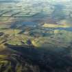
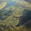
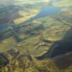
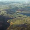
Threipmuir Reservoir


Dam (Period Unassigned), Reservoir (Period Unassigned)
Site Name Threipmuir Reservoir
Classification Dam (Period Unassigned), Reservoir (Period Unassigned)
Alternative Name(s) Pentland Hills
Canmore ID 135653
Site Number NT16SE 14
NGR NT 1760 6400
NGR Description Centred NT 1760 6400
Datum OSGB36 - NGR
Permalink http://canmore.org.uk/site/135653


- Council Edinburgh, City Of
- Parish Currie
- Former Region Lothian
- Former District City Of Edinburgh
- Former County Midlothian
NT16SE 44 centred 1760 6400
Threipmuir Reservoir
Top water level 254 metres above Newlyn datum [NAT]
OS 1:10,000 map, 1989.

