
Pricing Change
New pricing for orders of material from this site will come into place shortly. Charges for supply of digital images, digitisation on demand, prints and licensing will be altered.
Tom A' Chaisteal, Kirkton


Castle (Medieval), Fort (Period Unknown)
Site Name Tom A' Chaisteal, Kirkton
Classification Castle (Medieval), Fort (Period Unknown)
Alternative Name(s) Tom-a-chaisteal; Tom-a-chastle
Canmore ID 13556
Site Number NH64SW 9
NGR NH 60449 44894
Datum OSGB36 - NGR
Permalink http://canmore.org.uk/site/13556


- Council Highland
- Parish Kirkhill
- Former Region Highland
- Former District Inverness
- Former County Inverness-shire
NH64SW 9 6045 4490.
(NH 604 448) There are the remains of a castle on the hill known as Tom-a-Chaisteal (ISSFC 1885), Tom-a-Chastle (T Wallace 1893), or Tom-a'-Caisteal (T Wallace 1921), which is a small circular hill situated not far from the farm of Kirkton, between two confluent streams, the confluence occurring at the base on the N side of the hill. In 1206 the castle appears to have been occupied by Baron Thomson - a vassal of the Lovats - but in 1220 was in the possession, until 1498, of the Corbets, Barons of Farnaway. (ISSFC 1885)
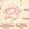
A fort (T Wallace 1921) occupies the top and measures 24 yds E-W by 19 yds N-S. On the S side there is a trench 18' wide by about 15' deep; this is not shown on sketch. On the N side is a trench 6' wide by 3' deep interrupted by an entrance path about 3' wide. Between this trench and the brow of the hill there is a ridge about 3' wide which merges into the hill on E and W. The streams have cut almost perpendicular walls around three-quarters of the hill.
ISSFC 1885; T Wallace 1893 and 1921.
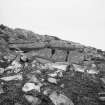
NH 6045 4480."Tom a' Chaisteal" is an isolated rocky knoll with steep sides. Its mutilated oval-shaped summit has two variant levels, the higher being on the W. Overall, the top measures 40.0m E-W by 18.0m. On the N edge is an almost rectangular hollow, now mainly filled up with soil slip. It is fronted on the N with a rubble wall now overgrown, 0.3m high, and the hollow, which is sub-divided by another rubble wall (T Wallace 1921) measures c. 16.0m E-W by 3.0m.
There is a similar structure at the E end of the site at the lower level. It measures c. 9.0m by 4.0m and there is a break of 1.0m in the centre of the rubble wall on the S side. These two described features have the appearance of having been buildings, not defensive trenches as suggested by Wallace. Abutting the S end of the northernmost "building" is a hollow which seems to have been enclosed by a bank or wall, but its purpose is uncertain. Traces of a wall are to be found round part of the W edge of the summit.
The "trench" on the S side of the knoll (T Wallace 1921) is a natural water-worn channel which served as an added defence to the site, and thus isolating it from the spur of which is was a part. At the base of the SE slopes of the knoll is a causeway-like ramp crossing a marshy channel, but it is too narrow (1.0m on top) to be the approach to the castle, and seems to be a dam of later date (there are several dams in the immediate area across stream gullies).
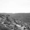
The whole site is in a commanding position at the confluence of the two streams, with the ground on the S gradually becoming higher some distance from the knoll.
There appears to be little doubt that this is a motte, or more properly a castle hill - site of the castle alleged by ISSFC 1885. The name is apparently not known in the locality.
Surveyed at 1:2500.
Visited by OS (J L D) 28 March 1962.
(NH 6045 4490) Tom-a'-Caisteal (NR)
OS 25"map, (1964)
Tom a' Caisteal is generally as described by OS field surveyor (J L D). The site occupies such a good position of natural strength that it is difficult to believe that it has not been exploited at one time for use as a fort or castle site, but the surviving structures on the knoll appear to be no earlier than, and are probably contemporary with, the dam in the SE (see enlargement). Both buildings and the wall around the brink in the N are reduced to their footings and overgrown with grass and bracken, and the NW end of the dam and the SW part of the adjacent building are hidden by impenetrable scrub. There are traces of an access ramp to the summit in the SW.
Visited by OS (A A) 12 September 1964
Tom a' Caisteal is generally as described by the two previous field investigators. In view of the name and the historical background together with the definite vantage position, a castle-site appears undisputed. There is no indication to suggest an earlier fortification such as a dun or fort.
Revised at 1:2500.
Visited by OS (J M) 9 Feburary 1981.
Field Visit (13 September 1943)
The name ‘Tom a’ Chaisteal’, recorded by Wallace, is not known at Kirkton, but the site was identified without difficulty from his description. The knoll in question stands about a quarter of a mile west of south of Kirkton Farm and forms the end of a promontory between two small glens on the west and north east; it is divided from the adjoining ground to the south and south east by a hollow, about 25ft deep, at the highest point of the saddle between the two glens. This hollow is evidently a natural one, but its sides may have been steepened artificially for defensive purposes. The summit of the knoll is very suitable for the site of a fort, but it was too thickly covered with bracken at the date of visit for any features to be identified. A few isolated stones were, however, found among the bracken, and the west part of the summit seems to be flattened if not actually somewhat dished.
Visited by RCAHMS (AG) 13 September 1943.
Field Visit (July 1979)
Tom a' Caisteal, Kirkton NH 604 449 NH64SW 9
This fort occupies a small but prominent knoll between the confluence of two streams. It measures 40m by 18m within the remains of a wall; the entrance probably lay on the SW. The fort was covered by dense vegetation at the date of visit.
RCAHMS 19879, visited July 1979
Transactions of the Inverness Scientific Society and Field Club, i, 1875-80, 82; iii, 1883-8, 134; viii 1912-18, 115)
Field Visit (July 1979)
Kirkton NH c.604 449 NH 64SW
Nothing can now be seen in an area of dense vegetation of the castle that was noted in 1877 close to the fort NH64SW 9. In 1206 the castle was occupied by a vassal of the Lovat family, but by 1220 it had passed to the Corbets, who held it until 1498.
RCAHMS 1979, visited July 1979
Transactions of the Inverness Scientific Society and Field Club, i, 187 5-80, 82

