
Following the launch of trove.scot in February 2025 we are now planning the retiral of some of our webservices. Canmore will be switched off on 24th June 2025. Information about the closure can be found on the HES website: Retiral of HES web services | Historic Environment Scotland
Arrochar, Royal Naval Torpedo Testing Station And Range


Building(S) (20th Century), Building (First World War), Jetty (20th Century), Pier (20th Century), Pier (First World War), Slipway (20th Century), Underwater Test Establishment (20th Century), Underwater Test Establishment (First World War), Underwater Test Establishment (Second World War)
Site Name Arrochar, Royal Naval Torpedo Testing Station And Range
Classification Building(S) (20th Century), Building (First World War), Jetty (20th Century), Pier (20th Century), Pier (First World War), Slipway (20th Century), Underwater Test Establishment (20th Century), Underwater Test Establishment (First World War), Underwater Test Establishment (Second World War)
Alternative Name(s) Loch Long; Ardnagal; Arrochar, Ministry Of Defence Jetty
Canmore ID 135114
Site Number NN20SE 28
NGR NN 28750 03950
NGR Description Centred NN 28750 03950
Datum OSGB36 - NGR
Permalink http://canmore.org.uk/site/135114


- Council Argyll And Bute
- Parish Lochgoilhead And Kilmorich
- Former Region Strathclyde
- Former District Argyll And Bute
- Former County Argyll
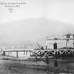
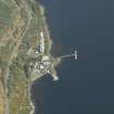
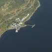
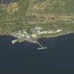
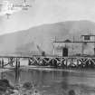
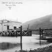
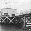
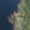
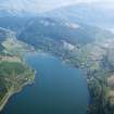
The torpedo testing station at Arrochar on Loch Long, was opened in April 1912, to test torpedoes manufactured at the Admiralty torpedo factory in Greenock. The loch provided a quiet stretch of water along which unarmed torpedoes could be fired, observed and then recovered.
The range closed in late 1986. The buildings survived until about 2007.
Information from HS/RCAHMS World War One Audit Project (GJB) 30 September 2013.
NN20SE 28 centred 28750 03950
Pier [NAT] (at NN 2868 0390)
OS 1:10,000 map, 1977.
Pier [NAT] (at NN 28676 03865)
Slipway [NAT] (at NN 28716 03888)
Jetty [NAT] (at NN 28836 03870)
OS (GIS) AIB, May 2006.
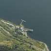
Construction (1915)
On west side of Loch Long, built c.1915. There is contradisctory evidence as to who designed the structure.
Information from R Paxton and Jim Shipway 2007b, 'Civil Engineering heritage: Scotland - Highlands and Islands' .
Publication Account (2007)
This jetty is an early reinforced concrete structure on the west side of Loch Long constructed ca.1915 for the Admiralty Torpedo Testing Station. The jetty comprises a deck with supporting columns and bracing, and bears a strong resemblance to a similar jetty at Suishnish, Isle of Raasay. Both are understood to have been designed about the same time by F. A. MacDonald & Partners of Edinburgh but are also included in Sir Robert McAlpine’s McAlpine Contracts (ca.1919, 85) as being built by them. McAlpines also state that they ‘were wholly responsible for the design of the reinforced concrete pier’. We have not been able to resolve this apparent contradiction! No public access is allowed.
R Paxton and Jim Shipway 2007b
Reproduced from 'Civil Engineering heritage: Scotland - Highlands and Islands' with kind permission from Thomas Telford Publishers.
Project (March 2013 - September 2013)
A project to characterise the quantity and quality of the Scottish resource of known surviving remains of the First World War. Carried out in partnership between Historic Scotland and RCAHMS.

