
Following the launch of trove.scot in February 2025 we are now planning the retiral of some of our webservices. Canmore will be switched off on 24th June 2025. Information about the closure can be found on the HES website: Retiral of HES web services | Historic Environment Scotland
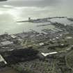
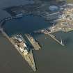
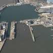
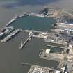
Rosyth, Hm Dockyard, Middle Pier


Pier (20th Century)
Site Name Rosyth, Hm Dockyard, Middle Pier
Classification Pier (20th Century)
Alternative Name(s) Rosyth Royal Dockyard; Fleet Maintenance Group; Hm Naval Base Rosyth
Canmore ID 134426
Site Number NT18SW 214
NGR NT 1011 8188
NGR Description From NT 1011 8188 to 0991 8195
Datum OSGB36 - NGR
Permalink http://canmore.org.uk/site/134426


- Council Fife
- Parish Dunfermline
- Former Region Fife
- Former District Dunfermline
- Former County Fife

