
Following the launch of trove.scot in February 2025 we are now planning the retiral of some of our webservices. Canmore will be switched off on 24th June 2025. Information about the closure can be found on the HES website: Retiral of HES web services | Historic Environment Scotland
Muir House


Cropmark(S) (Period Unknown), Rig And Furrow (Medieval) - (Post Medieval)
Site Name Muir House
Classification Cropmark(S) (Period Unknown), Rig And Furrow (Medieval) - (Post Medieval)
Canmore ID 134408
Site Number NO34NE 60
NGR NO 3787 4868
Datum OSGB36 - NGR
Permalink http://canmore.org.uk/site/134408


- Council Angus
- Parish Glamis
- Former Region Tayside
- Former District Angus
- Former County Angus
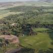
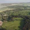
NO34NE 60 3787 4868.
Aerial photography (RCAHMSAP 1994, 1996) has recorded the cropmarks of rig-and-furrow-cultivation running WSW-ENE across a field immediately to the N of Parsonage and Warren. Indeterminate markings are scattered across this area, and the cropmarks of an unenclosed settlement and rig have been recorded in the adjacent field to the S (NO34NE 58).
Information from RCAHMS (KB) 22 February 2000

