
Following the launch of trove.scot in February 2025 we are now planning the retiral of some of our webservices. Canmore will be switched off on 24th June 2025. Information about the closure can be found on the HES website: Retiral of HES web services | Historic Environment Scotland
Mains Of Glamis


Linear Feature(S) (Period Unassigned)
Site Name Mains Of Glamis
Classification Linear Feature(S) (Period Unassigned)
Canmore ID 134405
Site Number NO34NE 59
NGR NO 391 478
NGR Description From NO 3907 4783 to NO 3936 4578
Datum OSGB36 - NGR
Permalink http://canmore.org.uk/site/134405


- Council Angus
- Parish Glamis
- Former Region Tayside
- Former District Angus
- Former County Angus
NO34NE 59 391 475
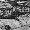
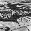
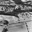
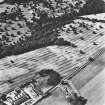
A pair of parallel linear cropmarks have been identified from air photography (RCAHMSAP 1994), running WNW - ESE 150 to the NW of Mains of Glamis farmstead. The cropmarks are visible from NO 3907 4783 to NO 3936 4578, a distance of 300m, and are roughly 40m apart. It is probable that these represent one of three tree-lined avenues which served Glamis Castle (NO34NE 1), in this case, the east avenue (Jervise 1861b). Although this section of avenue is not recorded on the 1st edition of the OS 6-inch map (Forfarshire 1865, sheet xxxviii), stretches of this avenue to the E and W of these cropmarks are still defined by tracks and field boundaries, and this is noticeable also on the most recent OS 1:10000 map sheet (1976). The continued route of the avenue W towards Glamis Castle is lined by trees (C 29708-10).
Information from RCAHMS (KB) 6 October 1998.

