
Pricing Change
New pricing for orders of material from this site will come into place shortly. Charges for supply of digital images, digitisation on demand, prints and licensing will be altered.
Tarbrax Branch, Caledonian Railway


Mineral Railway (Period Unassigned)
Site Name Tarbrax Branch, Caledonian Railway
Classification Mineral Railway (Period Unassigned)
Alternative Name(s) South Cobbinshaw Siding; Cobbinshaw Moss
Canmore ID 134160
Site Number NT05NW 53
NGR NT 01 56
NGR Description NT 0082 5724 to NT 0261 5541
Datum OSGB36 - NGR
Permalink http://canmore.org.uk/site/134160


- Council South Lanarkshire
- Parish Carnwath
- Former Region Strathclyde
- Former District Clydesdale
- Former County Lanarkshire
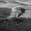
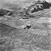
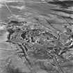
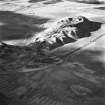
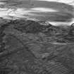
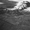
Aerial Photographic Interpretation (25 September 1998)
NT05NW 53 01 56 (NT 0082 5724 to NT 0261 5541)
A disused network of mineral railways running across Cobbinshaw Moss S of Cobbinshaw reservoir is visible on oblique air photographs (RCAHMSAP 1995). Two lines serviced a group of mines and works in the Cobbinshaw and Tarbrax area, neither of which are depicted on the 1st edition of the OS 6-inch map (Lanarkshire 1854, sheet xv, and Lanarkshire 1856, sheet xiv). Both are recorded on the 2nd edition of these OS maps (Lanarkshire 1899, sheet xiv NE & SE, and sheet xv SW, and Edinburgshire 1895, sheet xvii NW). The larger line, named as the 'Tarbrax Branch' of the Caledonian Railway, branches from the main Edinburgh to Carstairs line 700m SW of Cobbbinshaw station (NT05NW 21) at NT 0082 5724, and runs as far as Tarbrax Oil-shale works (NT05NW 10) at NT 0261 5541. This line presumably serviced South Cobbinshaw coal mine (NT05NW 43), and oil-shale mine (NT05NW 38). A second line, named the 'South Cobbinshaw Siding' and noted as being 'disused', branches off the Tarbrax Branch at NT 0160 5659, continuing as far N as NT 0273 5700, and beyond this point, continues as a tramway or less substantial mineral railway, until NT 0303 5769. 140m short of this terminus, it meets a tramway which runs from Cobbinshaw Hill coal mine (NT05NW 45).This branch also appears to have servived South Cobbinshaw Brickworks (NT05NW 37), and is linked to Cobbinshaw Pits (NT05NW 44) via a further tramway. The Tarbrax Branch is still recorded as being in use in the revised 2nd edition of the OS 6-inch map (Lanarkshire 1911, sheet xv.14, and sheet xiv.16, and Edinburghshire 1911, xvii.2).
Information from RCAHMS (KB), 25 September 1998.

