
Broom Hill


Field System(S) (Period Unassigned), Rig And Furrow (Medieval) - (Post Medieval)
Site Name Broom Hill
Classification Field System(S) (Period Unassigned), Rig And Furrow (Medieval) - (Post Medieval)
Canmore ID 133478
Site Number NT06SE 23
NGR NT 0971 6038
NGR Description NT 0873 6041 to NT 1060 6082
Datum OSGB36 - NGR
Permalink http://canmore.org.uk/site/133478


- Council West Lothian
- Parish Mid Calder
- Former Region Lothian
- Former District West Lothian
- Former County Midlothian
NT06SE 23 0873 6041 to 1060 6082
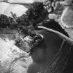
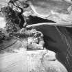
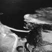
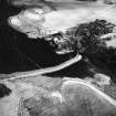
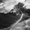
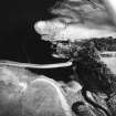
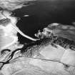
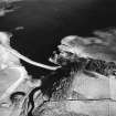
Identified from aerial photographs, an area of rig and furrow culivation and turf field boundaries on the southern edge of Harperrig Reservoir (see NT16SW 19), and centred on NT 0971 6038. From oblique aerial photographs and OS vertical photograph 73, 398/031, the rig can be seen to extend from the southern edge of the reservoir, as far S as NT 0956 5988, and from Cairns Castle Bridge, to as far E as NT 1060 6082. The rig seems to have been overlain by the reservoir, which does not appear until the time of the 2nd edition OS 6-inch map (Edinburghshire 1895, sheet xii NW). It continues to the northern side of the reservoir (see NT16SW 18).
Information from RCAHMS (KB) 3 September 1998
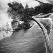
A field-system and a separate length of wall, all marked by pecked lines and annotated Old Fences, (centred on NT 098 602) are depicted on the 1st edition of the OS 6-inch map (Edinburghshire 1853-6, sheet x). The fragmentary remains of the field-system are shown on the current edition of the OS 1:10000 map (1976).
Information from RCAHMS (SAH) 11 October 2000

