
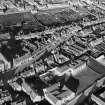
Forfar, Academy Street, Chapelpark Primary School, Main Block


School (19th Century)
Site Name Forfar, Academy Street, Chapelpark Primary School, Main Block
Classification School (19th Century)
Alternative Name(s) Forfar Academy
Canmore ID 133397
Site Number NO45SE 142
NGR NO 45920 50659
Datum OSGB36 - NGR
Permalink http://canmore.org.uk/site/133397


- Council Angus
- Parish Forfar
- Former Region Tayside
- Former District Angus
- Former County Angus
NO45SE 142.00 45920 50659
NO45SE 142.01 45864 50604 West Block
See catalogue for full RCAHMS collection
Standing Building Recording (27 May 2015)
NO 45920 50659 A Level 1 standing building survey was carried out, on 27 May 2015, of this early 19th-century school prior to its conversion to housing. Wings were added to the main school building in the late 19th century with a gymnasium also added around this time.
Archive: National Record of the Historic Environment (NRHE)
Funder: Angus Council
Alison Cameron – Cameron Archaeology
(Source: DES, Volume 16)

