
Morar


Village (Period Unassigned)
Site Name Morar
Classification Village (Period Unassigned)
Alternative Name(s) Morar Station
Canmore ID 133380
Site Number NM69SE 17
NGR NM 6775 9292
NGR Description Centred NM 6775 9292
Datum OSGB36 - NGR
Permalink http://canmore.org.uk/site/133380


- Council Highland
- Parish Glenelg (Lochaber)
- Former Region Highland
- Former District Lochaber
- Former County Inverness-shire
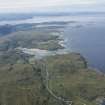
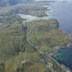
Morar Small village contemporary with the coming of the railway in 1901, taking its name from Scotland's deepest freshwater loch, which divides the rugged district into North and South Morar. Before 1901, there were just a few small crofting townships here, known collectively as Beoraid. Today, inevitably, suburban influences have penetrated, and Morar's frontier-post character of last century has all but disappeared.
Taken from "Western Seaboard: An Illustrated Architectural Guide", by Mary Miers, 2008. Published by the Rutland Press http://www.rias.org.uk

NM69SE 17 centred 6775 9292

