Accessibility

Font Size

100% 150% 200%

Background Colour

Default Contrast
Close Reset

Dysart, 11 - 13 Fitzroy Square

Term Pending (Period Unassigned)

Site Name Dysart, 11 - 13 Fitzroy Square

Classification Term Pending (Period Unassigned)

Alternative Name(s) St Davids?

Canmore ID 133361

Site Number NT39SW 125

NGR NT 3027 9308

Datum OSGB36 - NGR

Permalink http://canmore.org.uk/site/133361
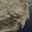
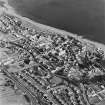
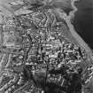
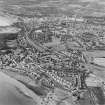
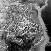
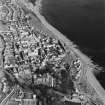
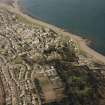
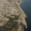
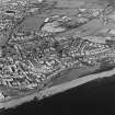
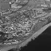
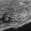
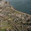
Ordnance Survey licence number AC0000807262. All rights reserved.
Canmore Disclaimer. © Bluesky International Limited 2025. Public Sector Viewing Terms

Toggle Aerial | View on large map

Digital Images

Phase 2, St. David's building and 11-13 Fitzroy Square, view from North
Phase 2, St. David's building and 11-13 Fitzroy Square, view from NorthPhase 2, St. David's building, detail of wall plaque (dated 1806)Oblique aerial view of Dysart centred on the village housing redevelopment designed by Wheeler and Sproson in 1958-71, and recorded as part of the Wheeler and Sproson Project and a Threatened Building Survey completed in 1997.  Taken from the SSW.Oblique aerial view of Dysart centred on the village housing redevelopment designed by Wheeler and Sproson in 1958-71, and recorded as part of the Wheeler and Sproson Project and a Threatened Building Survey completed in 1997.  Taken from the W.Oblique aerial view of Dysart centred on the village housing redevelopment designed by Wheeler and Sproson in 1958-71, and recorded as part of the Wheeler and Sproson Project and a Threatened Building Survey completed in 1997.  Taken from the SSW.Oblique aerial view of Dysart centred on the village housing redevelopment designed by Wheeler and Sproson in 1958-71, and recorded as part of the Wheeler and Sproson Project and a Threatened Building Survey completed in 1997.  Taken from the ENE.Oblique aerial view of Dysart centred on the village housing redevelopment designed by Wheeler and Sproson in 1958-71, and recorded as part of the Wheeler and Sproson Project and a Threatened Building Survey completed in 1997.  Taken from the W.Oblique aerial view of Dysart centred on the village housing redevelopment designed by Wheeler and Sproson in 1958-71, and recorded as part of the Wheeler and Sproson Project and a Threatened Building Survey completed in 1997.  Taken from the SW.Phase 2, St. David's building, detail of wall plaque (dated 1806)Phase 2, St. David's building and 11-13 Fitzroy Square, view from NorthOblique aerial view of Dysart centred on the village housing redevelopment designed by Wheeler and Sproson in 1958-71, and recorded as part of the Wheeler and Sproson Project and a Threatened Building Survey completed in 1997.  Taken from the WSW.Oblique aerial view of Dysart centred on the village housing redevelopment designed by Wheeler and Sproson in 1958-71, and recorded as part of the Wheeler and Sproson Project and a Threatened Building Survey completed in 1997.  Taken from the SW.Oblique aerial view of Dysart centred on the village housing redevelopment designed by Wheeler and Sproson in 1958-71, and recorded as part of the Wheeler and Sproson Project and a Threatened Building Survey completed in 1997.  Taken from the ESE.Oblique aerial view of Dysart centred on the village housing redevelopment designed by Wheeler and Sproson in 1958-71, and recorded as part of the Wheeler and Sproson Project and a Threatened Building Survey completed in 1997.  Taken from the SSE.Oblique aerial view of Dysart centred on the village housing redevelopment designed by Wheeler and Sproson in 1958-71, and recorded as part of the Wheeler and Sproson Project and a Threatened Building Survey completed in 1997.  Taken from the SE.Oblique aerial view of Dysart centred on the village housing redevelopment designed by Wheeler and Sproson in 1958-71, and recorded as part of the Wheeler and Sproson Project and a Threatened Building Survey completed in 1997.  Taken from the W.Oblique aerial view of Dysart centred on the village housing redevelopment designed by Wheeler and Sproson in 1958-71, and recorded as part of the Wheeler and Sproson Project and a Threatened Building Survey completed in 1997.  Taken from the NE.Oblique aerial view of Dysart centred on the village housing redevelopment designed by Wheeler and Sproson in 1958-71, and recorded as part of the Wheeler and Sproson Project and a Threatened Building Survey completed in 1997.  Taken from the S.

Administrative Areas

  • Council Fife
  • Parish Kirkcaldy And Dysart
  • Former Region Fife
  • Former District Kirkcaldy
  • Former County Fife

Architecture Notes

ARCHITECTS: Wheeler and Sprosan, phase I, II and III: 1958 - 77

References

MyCanmore Image Contributions


Contribute an Image

MyCanmore Text Contributions