
Letterfourie House, Craigmin Bridge


Road Bridge (18th Century)
Site Name Letterfourie House, Craigmin Bridge
Classification Road Bridge (18th Century)
Alternative Name(s) Leterfourie House Policies; Burn Of Letterfourie; Letterfourie, Estate Bridge
Canmore ID 133305
Site Number NJ46SW 35.06
NGR NJ 44103 62126
Datum OSGB36 - NGR
Permalink http://canmore.org.uk/site/133305


- Council Moray
- Parish Rathven
- Former Region Grampian
- Former District Moray
- Former County Banffshire
NJ46SW 35.06 44103 62126
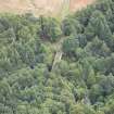
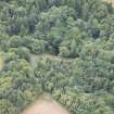
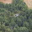
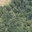
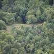
(Location cited as NJ 441 621). Craigmin Bridge, Letterfourie, late 18th century. An extraordinary 'three-tier' rubble estate bridge, spanning a deep valley. At the base is a segmental arch. Above this are two semicircular arches, which are topped by a smaller segmental arch. The parapets curve down from the abutments and up to the centre, where there is a round-headed niche.
J R Hume 1977.
High picturesque 2-tier structure, lower single span supporting double span; rubble, tooled rubble dressings. Tooled rubble arch rings, the upper pair linked by mural passage and with shallow round-headed niche in upper spandrel. End buttresses; undulating low rubble parapet with unfortunate later concrete cope. Spans: lower arch - 36'6" upper arches - 28'.
Most unusual bridge. No drawings nor documentation survive. It is just possible that the lower arch is earlier, but when the mansion was built and a carriage drive required, the second tier was added to accommodate horse drawn vehicles (lower bridge would have had too steep approach over gorge for these). The approach from the west to Letterfourie was by this route. (Historic Scotland)

