
Patterton, Rifle Range


Firing Range (19th Century) - (20th Century)
Site Name Patterton, Rifle Range
Classification Firing Range (19th Century) - (20th Century)
Canmore ID 133259
Site Number NS55NW 57
NGR NS 5310 5835
NGR Description Centred NS 5310 5835
Datum OSGB36 - NGR
Permalink http://canmore.org.uk/site/133259
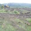
![Archaeological evaluation, View of trench 3 showing ditch cut [007] from N, Darnley Mains](http://i.rcahms.gov.uk/canmore/l/DP00302124.jpg)

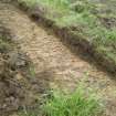
![Archaeological evaluation, View of trench 4 showing ditch cut [005] from W, Darnley Mains](http://i.rcahms.gov.uk/canmore/l/DP00302128.jpg)
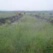
![Archaeological evaluation, View of trench 7 showing wall foundation [002] from N, Darnley Mains](http://i.rcahms.gov.uk/canmore/l/DP00302130.jpg)
![Archaeological evaluation, Section through wall foundation [002] in trench
5 from N, Darnley Mains](http://i.rcahms.gov.uk/canmore/l/DP00302137.jpg)


![Archaeological evaluation, View of trench 3 showing ditch cut [007] from N, Darnley Mains](http://i.rcahms.gov.uk/canmore/s/DP00302124.jpg)
![Archaeological evaluation, View of trench 4 showing ditch cut [005] from W, Darnley Mains](http://i.rcahms.gov.uk/canmore/s/DP00302128.jpg)
![Archaeological evaluation, View of trench 7 showing wall foundation [002] from N, Darnley Mains](http://i.rcahms.gov.uk/canmore/s/DP00302130.jpg)
![Archaeological evaluation, Section through wall foundation [002] in trench
5 from N, Darnley Mains](http://i.rcahms.gov.uk/canmore/s/DP00302137.jpg)
- Council Glasgow, City Of
- Parish Eastwood (City Of Glasgow)
- Former Region Strathclyde
- Former District City Of Glasgow
- Former County Lanarkshire
NS55NW 57 centred 5310 5835
NS 532 583 Rifle range, probably WWI in date.
(Information supplied by Mr Parry)
Strathclyde Regional Council SMR 1995.
The firing trench of this rifle range is visible on post-war RAF vertical air photographs (106G/Scot/UK 140, Pt.III, 5275-7, flown 3 July 1946) within a wooded area about 400m NW of Patterton farmsteading. The trench is also depicted on the current OS 1:10000 scale map (1990). It is possible that these ranges were utilised in World War II.
Information from RCAHMS (DE), January 2002
Archaeological Evaluation (26 June 2013 - 27 June 2013)
NS 53566 58609 A trial trenching evaluation was undertaken, 26–27 June 2013, prior to development. A total of 13 trenches, covering 458m, were excavated with the goal of locating evidence of Clogholes Farmstead, which is marked on the 1st Edition OS map. No evidence of the farmstead was located; however, the foundations of a stone boundary wall thought to be contemporary with the farmstead were recorded. Two linear ditches were also identified, although the modern finds recovered from the fills indicated they were 20th-century in date. The finds included a number of bullet cartridges associated with the area’s use as a rifle range in the early 20th century. A number of tile field drains were also noted.
Archive: RCAHMS
Funder: Meridian Developments Ltd
Donald Wilson, Headland Archaeology Ltd, 2013
(Source: DES)
OASIS ID: headland1-154103

