
Unst, Muness Castle


Mound (Period Unassigned)
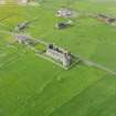
Site Name Unst, Muness Castle
Classification Mound (Period Unassigned)
Canmore ID 133
Site Number HP60SW 31
NGR HP 62957 01134
Datum OSGB36 - NGR
Permalink http://canmore.org.uk/site/133


- Council Shetland Islands
- Parish Unst
- Former Region Shetland Islands Area
- Former District Shetland
- Former County Shetland
Field Visit (28 April 2010)
This grass-grown stony mound, which is situated in improved pasture 13m S of the S tower of Muness Castle, measures about 7.5m from N to S by 6m transversely and up to 1m in height.
Visited by RCAHMS (GLB) 28 April 2010

