
Forest Avenue


Enclosure (Period Unassigned)
Site Name Forest Avenue
Classification Enclosure (Period Unassigned)
Alternative Name(s) East Kinmonth; Pitdrichie
Canmore ID 132883
Site Number NO78SE 41
NGR NO 7936 8180
Datum OSGB36 - NGR
Permalink http://canmore.org.uk/site/132883


- Council Aberdeenshire
- Parish Glenbervie
- Former Region Grampian
- Former District Kincardine And Deeside
- Former County Kincardineshire
NO78SE 41 7936 8180
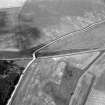
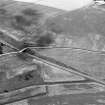
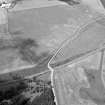
(Location cited as NO 7935 8179). Air photography (AAS/83/08/R13/6-8 and AAS/83/08/S3/20, flown 20 July 1983) has recorded the cropmark of a circular enclosure on a gentle slope at an altitude of 113m OD.
NMRS, MS/712/35.

