
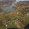
Lewis, Grimshader


Farmstead (Period Unassigned), Head Dyke (Post Medieval), Township (Period Unassigned)
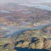
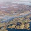
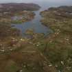
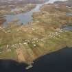
Site Name Lewis, Grimshader
Classification Farmstead (Period Unassigned), Head Dyke (Post Medieval), Township (Period Unassigned)
Alternative Name(s) Griomsiader, Grimashadar, Griomsidar
Canmore ID 132183
Site Number NB42NW 1
NGR NB 4070 2560
NGR Description Centred NB 4070 2560
Datum OSGB36 - NGR
Permalink http://canmore.org.uk/site/132183


- Council Western Isles
- Parish Lochs
- Former Region Western Isles Islands Area
- Former District Western Isles
- Former County Ross And Cromarty
Note
A township and a farmstead are depicted on the 1st edition of the OS 6-inch map (Ross-shire, Island of Lewis 1854, sheet 33). The township comprises nine roofed buildings, two partially roofed buildings, one of which is annotated as a Ruin, eight unroofed buildings, one of which is also annotated as a Ruin, nine enclosures and a head-dyke, part of which is shared with the township NB32NE 4.01 to the W. The farmstead (NB 4156 2600) comprises one roofed building, one enclosure and a head-dyke.
Thirty-three roofed, one partially roofed, four unroofed buildingsand severla enclosures are shown on the current edition of the OS 1:10000 map (1973).
Information from RCAHMS (SAH) 25 July 1997.

