
Tomicaldonich


Farmstead (Period Unassigned), Head Dyke (Post Medieval)
Site Name Tomicaldonich
Classification Farmstead (Period Unassigned), Head Dyke (Post Medieval)
Canmore ID 131650
Site Number NN76NW 5
NGR NN 7416 6936
Datum OSGB36 - NGR
Permalink http://canmore.org.uk/site/131650

- Council Perth And Kinross
- Parish Blair Atholl
- Former Region Tayside
- Former District Perth And Kinross
- Former County Perthshire
Field Visit (15 July 2019 - 9 October 2019)
A historic environment assessment was undertaken by Rathemll Archaeology between 15th July 2019 and 9th October 2019, to inform a proposed planting scheme at Dall, near Struan, Perth & Kinross. A desk-based assessment and walkover survey was designed to establish a sound baseline on the historic environment within the landholding and to make recommendations on its management. The findings of the assessment and survey are presented in this report.
Five historic environment sites were identified and are considered within this report These are: three cairns, a field boundary and an offcut section of an 18th century Military Road.
Based on the evidence gathered for this assessment, positive management has been recommended to safeguard the field boundary and 18th century military road.
Information from: Sarah Krischer and Laura Anderson (Rathmell Archaeology) 2nd August 2019
OASIS ID: rathmell1-363023
Note
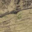
A farmstead comprising two unroofed buildings, which are annotated as Ruins, and two enclosures, and two lengths of head-dyke, to the E and the W, are depicted on the 1st edition of the OS 6-inch map (Perthshire 1867, sheet xx). The head-dyke to the W conjoins to the farmstead of East Dail-an-Fhraoich (NN76NW 4).
Two unroofed buildings, two enclosures and the two lengths of head-dyke are shown on the current edition of the OS 1:10000 map (1974).
Information from RCAHMS (SAH) 25 September 1997

