
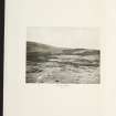
Allt Kinardochy


Farmstead (Period Unassigned)
Site Name Allt Kinardochy
Classification Farmstead (Period Unassigned)
Alternative Name(s) Kinardochy
Canmore ID 131640
Site Number NN75NE 56
NGR NN 7770 5689
Datum OSGB36 - NGR
Permalink http://canmore.org.uk/site/131640
Ordnance Survey licence number AC0000807262. All rights reserved.
Canmore Disclaimer.
© Bluesky International Limited 2025. Public Sector Viewing Terms
- Correction
- Favourite

SC 2152287
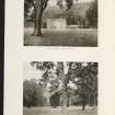
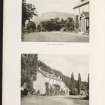
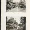
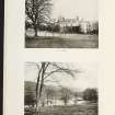
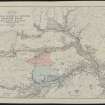
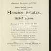
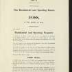
Estate Exchange. The Menzies Estate. nos. 1522 & 1523 Sale Brochure 1914. Title: 'The Menzies Estates'. Dalrawer Farm, Domnaheiche, Donafull farm, Donlellan with Burnside, Glassie Farm, Kinardochy Farm, Glengowlandie Farm, Camusericht Farm, Carse Farm, Corrievarkie Lodge, Croft Na Muick Farm, Craiganour Lodge, Shenvail Farm, Frenich Farm, Foss Home farm, Tirinie Farm
Collection of sale catalogues relating to Scottish estates
29/5/1914
© Courtesy of HES (Estates Exchange Collection)

SC 2152299
Estate Exchange. The Menzies Estate. nos. 1522 & 1523 Sale Brochure 1914. Title: 'The Menzies Estates'. Dalrawer Farm, Domnaheiche, Donafull farm, Donlellan with Burnside, Glassie Farm, Kinardochy Farm, Glengowlandie Farm, Camusericht Farm, Carse Farm, Corrievarkie Lodge, Croft Na Muick Farm, Craiganour Lodge, Shenvail Farm, Frenich Farm, Foss Home farm, Tirinie Farm
Collection of sale catalogues relating to Scottish estates
29/5/1914
© Courtesy of HES (Estates Exchange Collection)

SC 2152304
Estate Exchange. The Menzies Estate. nos. 1522 & 1523 Sale Brochure 1914. Title: 'The Menzies Estates'. Dalrawer Farm, Domnaheiche, Donafull farm, Donlellan with Burnside, Glassie Farm, Kinardochy Farm, Glengowlandie Farm, Camusericht Farm, Carse Farm, Corrievarkie Lodge, Croft Na Muick Farm, Craiganour Lodge, Shenvail Farm, Frenich Farm, Foss Home farm, Tirinie Farm
Collection of sale catalogues relating to Scottish estates
29/5/1914
© Courtesy of HES (Estates Exchange Collection)

SC 2152309
Estate Exchange. The Menzies Estate. nos. 1522 & 1523 Sale Brochure 1914. Title: 'The Menzies Estates'. Dalrawer Farm, Domnaheiche, Donafull farm, Donlellan with Burnside, Glassie Farm, Kinardochy Farm, Glengowlandie Farm, Camusericht Farm, Carse Farm, Corrievarkie Lodge, Croft Na Muick Farm, Craiganour Lodge, Shenvail Farm, Frenich Farm, Foss Home farm, Tirinie Farm
Collection of sale catalogues relating to Scottish estates
29/5/1914
© Courtesy of HES (Estates Exchange Collection)

SC 2152312
Estate Exchange. The Menzies Estate. nos. 1522 & 1523 Sale Brochure 1914. Title: 'The Menzies Estates'. Dalrawer Farm, Domnaheiche, Donafull farm, Donlellan with Burnside, Glassie Farm, Kinardochy Farm, Glengowlandie Farm, Camusericht Farm, Carse Farm, Corrievarkie Lodge, Croft Na Muick Farm, Craiganour Lodge, Shenvail Farm, Frenich Farm, Foss Home farm, Tirinie Farm
Collection of sale catalogues relating to Scottish estates
29/5/1914
© Courtesy of HES (Estates Exchange Collection)

SC 2152321
Estate Exchange. The Menzies Estate. nos. 1522 & 1523 Sale Brochure 1914. Title: 'The Menzies Estates'. Dalrawer Farm, Domnaheiche, Donafull farm, Donlellan with Burnside, Glassie Farm, Kinardochy Farm, Glengowlandie Farm, Camusericht Farm, Carse Farm, Corrievarkie Lodge, Croft Na Muick Farm, Craiganour Lodge, Shenvail Farm, Frenich Farm, Foss Home farm, Tirinie Farm
Collection of sale catalogues relating to Scottish estates
29/5/1914
© Courtesy of HES (Estates Exchange Collection)

SC 2152324
Estate Exchange. The Menzies Estate. nos. 1522 & 1523 Sale Brochure 1914. Title: 'The Menzies Estates'. Dalrawer Farm, Domnaheiche, Donafull farm, Donlellan with Burnside, Glassie Farm, Kinardochy Farm, Glengowlandie Farm, Camusericht Farm, Carse Farm, Corrievarkie Lodge, Croft Na Muick Farm, Craiganour Lodge, Shenvail Farm, Frenich Farm, Foss Home farm, Tirinie Farm
Collection of sale catalogues relating to Scottish estates
29/5/1914
© Courtesy of HES (Estates Exchange Collection)

SC 2152327
Estate Exchange. The Menzies Estate. nos. 1522 & 1523 Sale Brochure 1914. Title: 'The Menzies Estates'. Dalrawer Farm, Domnaheiche, Donafull farm, Donlellan with Burnside, Glassie Farm, Kinardochy Farm, Glengowlandie Farm, Camusericht Farm, Carse Farm, Corrievarkie Lodge, Croft Na Muick Farm, Craiganour Lodge, Shenvail Farm, Frenich Farm, Foss Home farm, Tirinie Farm
Collection of sale catalogues relating to Scottish estates
29/5/1914
© Courtesy of HES (Estates Exchange Collection)

SC 2152569
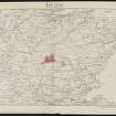
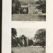
Estate Exchange. Menzies estates. no. 1521. Sale Brochure Domaheiche, Donlellan with Burnside, Camusericht Farm, Corrievarkie Lodge, Craiganour Lodge, Aulich Farm, Frenich Farm. Title: 'The Menzies Estates in Rannoch & Foss ...'
Collection of sale catalogues relating to Scottish estates
11/7/1911
© Courtesy of HES (Estates Exchange Collection)

SC 2152574
Estate Exchange. Menzies estates. no. 1521. Sale Brochure Domaheiche, Donlellan with Burnside, Camusericht Farm, Corrievarkie Lodge, Craiganour Lodge, Aulich Farm, Frenich Farm. Title: 'The Menzies Estates in Rannoch & Foss ...'
Collection of sale catalogues relating to Scottish estates
11/7/1911
© Courtesy of HES (Estates Exchange Collection)

SC 2152581
Estate Exchange. Menzies estates. no. 1521. Sale Brochure Domaheiche, Donlellan with Burnside, Camusericht Farm, Corrievarkie Lodge, Craiganour Lodge, Aulich Farm, Frenich Farm. Title: 'The Menzies Estates in Rannoch & Foss ...'
Collection of sale catalogues relating to Scottish estates
11/7/1911
© Courtesy of HES (Estates Exchange Collection)

SC 2152586
Estate Exchange. Menzies estates. no. 1521. Sale Brochure Domaheiche, Donlellan with Burnside, Camusericht Farm, Corrievarkie Lodge, Craiganour Lodge, Aulich Farm, Frenich Farm. Title: 'The Menzies Estates in Rannoch & Foss ...'
Collection of sale catalogues relating to Scottish estates
11/7/1911
© Courtesy of HES (Estates Exchange Collection)

SC 2152593
Estate Exchange. Menzies estates. no. 1521. Sale Brochure Domaheiche, Donlellan with Burnside, Camusericht Farm, Corrievarkie Lodge, Craiganour Lodge, Aulich Farm, Frenich Farm. Title: 'The Menzies Estates in Rannoch & Foss ...'
Collection of sale catalogues relating to Scottish estates
11/7/1911
© Courtesy of HES (Estates Exchange Collection)

SC 2152601
Estate Exchange. Menzies estates. no. 1521. Sale Brochure Domaheiche, Donlellan with Burnside, Camusericht Farm, Corrievarkie Lodge, Craiganour Lodge, Aulich Farm, Frenich Farm. Title: 'The Menzies Estates in Rannoch & Foss ...'
Collection of sale catalogues relating to Scottish estates
11/7/1911
© Courtesy of HES (Estates Exchange Collection)

SC 2152602
Estate Exchange. Menzies estates. no. 1521. Sale Brochure Domaheiche, Donlellan with Burnside, Camusericht Farm, Corrievarkie Lodge, Craiganour Lodge, Aulich Farm, Frenich Farm. Title: 'The Menzies Estates in Rannoch & Foss ...'
Collection of sale catalogues relating to Scottish estates
11/7/1911
© Courtesy of HES (Estates Exchange Collection)

SC 2152608
Estate Exchange. Menzies estates. no. 1521. Sale Brochure Domaheiche, Donlellan with Burnside, Camusericht Farm, Corrievarkie Lodge, Craiganour Lodge, Aulich Farm, Frenich Farm. Title: 'The Menzies Estates in Rannoch & Foss ...'
Collection of sale catalogues relating to Scottish estates
11/7/1911
© Courtesy of HES (Estates Exchange Collection)

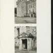
SC 1701045
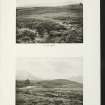
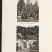
Oblique aerial view centred on the remains of the homestead with the remains of the farmsteads adjacent, taken from the W.
RCAHMS Aerial Photography
9/2/2001
© Crown Copyright: HES

SC 2152293
Estate Exchange. The Menzies Estate. nos. 1522 & 1523 Sale Brochure 1914. Title: 'The Menzies Estates'. Dalrawer Farm, Domnaheiche, Donafull farm, Donlellan with Burnside, Glassie Farm, Kinardochy Farm, Glengowlandie Farm, Camusericht Farm, Carse Farm, Corrievarkie Lodge, Croft Na Muick Farm, Craiganour Lodge, Shenvail Farm, Frenich Farm, Foss Home farm, Tirinie Farm
Collection of sale catalogues relating to Scottish estates
29/5/1914
© Courtesy of HES (Estates Exchange Collection)

SC 2152320
Estate Exchange. The Menzies Estate. nos. 1522 & 1523 Sale Brochure 1914. Title: 'The Menzies Estates'. Dalrawer Farm, Domnaheiche, Donafull farm, Donlellan with Burnside, Glassie Farm, Kinardochy Farm, Glengowlandie Farm, Camusericht Farm, Carse Farm, Corrievarkie Lodge, Croft Na Muick Farm, Craiganour Lodge, Shenvail Farm, Frenich Farm, Foss Home farm, Tirinie Farm
Collection of sale catalogues relating to Scottish estates
29/5/1914
© Courtesy of HES (Estates Exchange Collection)

SC 2152336
Estate Exchange. The Menzies Estate. nos. 1522 & 1523 Sale Brochure 1914. Title: 'The Menzies Estates'. Dalrawer Farm, Domnaheiche, Donafull farm, Donlellan with Burnside, Glassie Farm, Kinardochy Farm, Glengowlandie Farm, Camusericht Farm, Carse Farm, Corrievarkie Lodge, Croft Na Muick Farm, Craiganour Lodge, Shenvail Farm, Frenich Farm, Foss Home farm, Tirinie Farm
Collection of sale catalogues relating to Scottish estates
29/5/1914
© Courtesy of HES (Estates Exchange Collection)

SC 2152561
Estate Exchange. Menzies estates. no. 1521. Sale Brochure Domaheiche, Donlellan with Burnside, Camusericht Farm, Corrievarkie Lodge, Craiganour Lodge, Aulich Farm, Frenich Farm. Title: 'The Menzies Estates in Rannoch & Foss ...'
Collection of sale catalogues relating to Scottish estates
11/7/1911
© Courtesy of HES (Estates Exchange Collection)

SC 2152563
Estate Exchange. Menzies estates. no. 1521. Sale Brochure Domaheiche, Donlellan with Burnside, Camusericht Farm, Corrievarkie Lodge, Craiganour Lodge, Aulich Farm, Frenich Farm. Title: 'The Menzies Estates in Rannoch & Foss ...'
Collection of sale catalogues relating to Scottish estates
11/7/1911
© Courtesy of HES (Estates Exchange Collection)

SC 2152565
Estate Exchange. Menzies estates. no. 1521. Sale Brochure Domaheiche, Donlellan with Burnside, Camusericht Farm, Corrievarkie Lodge, Craiganour Lodge, Aulich Farm, Frenich Farm. Title: 'The Menzies Estates in Rannoch & Foss ...'
Collection of sale catalogues relating to Scottish estates
11/7/1911
© Courtesy of HES (Estates Exchange Collection)

SC 2152567
Estate Exchange. Menzies estates. no. 1521. Sale Brochure Domaheiche, Donlellan with Burnside, Camusericht Farm, Corrievarkie Lodge, Craiganour Lodge, Aulich Farm, Frenich Farm. Title: 'The Menzies Estates in Rannoch & Foss ...'
Collection of sale catalogues relating to Scottish estates
11/7/1911
© Courtesy of HES (Estates Exchange Collection)

SC 2152580
Estate Exchange. Menzies estates. no. 1521. Sale Brochure Domaheiche, Donlellan with Burnside, Camusericht Farm, Corrievarkie Lodge, Craiganour Lodge, Aulich Farm, Frenich Farm. Title: 'The Menzies Estates in Rannoch & Foss ...'
Collection of sale catalogues relating to Scottish estates
11/7/1911
© Courtesy of HES (Estates Exchange Collection)

SC 2152585
Estate Exchange. Menzies estates. no. 1521. Sale Brochure Domaheiche, Donlellan with Burnside, Camusericht Farm, Corrievarkie Lodge, Craiganour Lodge, Aulich Farm, Frenich Farm. Title: 'The Menzies Estates in Rannoch & Foss ...'
Collection of sale catalogues relating to Scottish estates
11/7/1911
© Courtesy of HES (Estates Exchange Collection)

SC 2152589
Estate Exchange. Menzies estates. no. 1521. Sale Brochure Domaheiche, Donlellan with Burnside, Camusericht Farm, Corrievarkie Lodge, Craiganour Lodge, Aulich Farm, Frenich Farm. Title: 'The Menzies Estates in Rannoch & Foss ...'
Collection of sale catalogues relating to Scottish estates
11/7/1911
© Courtesy of HES (Estates Exchange Collection)

SC 2152597
Estate Exchange. Menzies estates. no. 1521. Sale Brochure Domaheiche, Donlellan with Burnside, Camusericht Farm, Corrievarkie Lodge, Craiganour Lodge, Aulich Farm, Frenich Farm. Title: 'The Menzies Estates in Rannoch & Foss ...'
Collection of sale catalogues relating to Scottish estates
11/7/1911
© Courtesy of HES (Estates Exchange Collection)

SC 2152603
Estate Exchange. Menzies estates. no. 1521. Sale Brochure Domaheiche, Donlellan with Burnside, Camusericht Farm, Corrievarkie Lodge, Craiganour Lodge, Aulich Farm, Frenich Farm. Title: 'The Menzies Estates in Rannoch & Foss ...'
Collection of sale catalogues relating to Scottish estates
11/7/1911
© Courtesy of HES (Estates Exchange Collection)

SC 2152610
Estate Exchange. Menzies estates. no. 1521. Sale Brochure Domaheiche, Donlellan with Burnside, Camusericht Farm, Corrievarkie Lodge, Craiganour Lodge, Aulich Farm, Frenich Farm. Title: 'The Menzies Estates in Rannoch & Foss ...'
Collection of sale catalogues relating to Scottish estates
11/7/1911
© Courtesy of HES (Estates Exchange Collection)

SC 2152611
Estate Exchange. Menzies estates. no. 1521. Sale Brochure Domaheiche, Donlellan with Burnside, Camusericht Farm, Corrievarkie Lodge, Craiganour Lodge, Aulich Farm, Frenich Farm. Title: 'The Menzies Estates in Rannoch & Foss ...'
Collection of sale catalogues relating to Scottish estates
11/7/1911
© Courtesy of HES (Estates Exchange Collection)

SC 1701046
Oblique aerial view centred on the remains of the homestead with the remains of the farmsteads adjacent, taken from the SW.
RCAHMS Aerial Photography
9/2/2001
© Crown Copyright: HES

SC 1701053
Oblique aerial view centred on the remains of the farmstead with the remains of the farmsteads, possible homestead, farmhouse, farmsteading and head-dyke adjacent, taken from the NE.
RCAHMS Aerial Photography
9/2/2001
© Crown Copyright: HES

SC 2152286
Estate Exchange. The Menzies Estate. nos. 1522 & 1523 Sale Brochure 1914. Title: 'The Menzies Estates'. Dalrawer Farm, Domnaheiche, Donafull farm, Donlellan with Burnside, Glassie Farm, Kinardochy Farm, Glengowlandie Farm, Camusericht Farm, Carse Farm, Corrievarkie Lodge, Croft Na Muick Farm, Craiganour Lodge, Shenvail Farm, Frenich Farm, Foss Home farm, Tirinie Farm
Collection of sale catalogues relating to Scottish estates
29/5/1914
© Courtesy of HES (Estates Exchange Collection)

SC 2152302
Estate Exchange. The Menzies Estate. nos. 1522 & 1523 Sale Brochure 1914. Title: 'The Menzies Estates'. Dalrawer Farm, Domnaheiche, Donafull farm, Donlellan with Burnside, Glassie Farm, Kinardochy Farm, Glengowlandie Farm, Camusericht Farm, Carse Farm, Corrievarkie Lodge, Croft Na Muick Farm, Craiganour Lodge, Shenvail Farm, Frenich Farm, Foss Home farm, Tirinie Farm
Collection of sale catalogues relating to Scottish estates
29/5/1914
© Courtesy of HES (Estates Exchange Collection)

SC 2152305
Estate Exchange. The Menzies Estate. nos. 1522 & 1523 Sale Brochure 1914. Title: 'The Menzies Estates'. Dalrawer Farm, Domnaheiche, Donafull farm, Donlellan with Burnside, Glassie Farm, Kinardochy Farm, Glengowlandie Farm, Camusericht Farm, Carse Farm, Corrievarkie Lodge, Croft Na Muick Farm, Craiganour Lodge, Shenvail Farm, Frenich Farm, Foss Home farm, Tirinie Farm
Collection of sale catalogues relating to Scottish estates
29/5/1914
© Courtesy of HES (Estates Exchange Collection)

SC 2152325
Estate Exchange. The Menzies Estate. nos. 1522 & 1523 Sale Brochure 1914. Title: 'The Menzies Estates'. Dalrawer Farm, Domnaheiche, Donafull farm, Donlellan with Burnside, Glassie Farm, Kinardochy Farm, Glengowlandie Farm, Camusericht Farm, Carse Farm, Corrievarkie Lodge, Croft Na Muick Farm, Craiganour Lodge, Shenvail Farm, Frenich Farm, Foss Home farm, Tirinie Farm
Collection of sale catalogues relating to Scottish estates
29/5/1914
© Courtesy of HES (Estates Exchange Collection)

SC 2152328
Estate Exchange. The Menzies Estate. nos. 1522 & 1523 Sale Brochure 1914. Title: 'The Menzies Estates'. Dalrawer Farm, Domnaheiche, Donafull farm, Donlellan with Burnside, Glassie Farm, Kinardochy Farm, Glengowlandie Farm, Camusericht Farm, Carse Farm, Corrievarkie Lodge, Croft Na Muick Farm, Craiganour Lodge, Shenvail Farm, Frenich Farm, Foss Home farm, Tirinie Farm
Collection of sale catalogues relating to Scottish estates
29/5/1914
© Courtesy of HES (Estates Exchange Collection)

SC 2152562
Estate Exchange. Menzies estates. no. 1521. Sale Brochure Domaheiche, Donlellan with Burnside, Camusericht Farm, Corrievarkie Lodge, Craiganour Lodge, Aulich Farm, Frenich Farm. Title: 'The Menzies Estates in Rannoch & Foss ...'
Collection of sale catalogues relating to Scottish estates
11/7/1911
© Courtesy of HES (Estates Exchange Collection)

SC 2152588
Estate Exchange. Menzies estates. no. 1521. Sale Brochure Domaheiche, Donlellan with Burnside, Camusericht Farm, Corrievarkie Lodge, Craiganour Lodge, Aulich Farm, Frenich Farm. Title: 'The Menzies Estates in Rannoch & Foss ...'
Collection of sale catalogues relating to Scottish estates
11/7/1911
© Courtesy of HES (Estates Exchange Collection)

SC 2152591
Estate Exchange. Menzies estates. no. 1521. Sale Brochure Domaheiche, Donlellan with Burnside, Camusericht Farm, Corrievarkie Lodge, Craiganour Lodge, Aulich Farm, Frenich Farm. Title: 'The Menzies Estates in Rannoch & Foss ...'
Collection of sale catalogues relating to Scottish estates
11/7/1911
© Courtesy of HES (Estates Exchange Collection)

SC 2152599
Estate Exchange. Menzies estates. no. 1521. Sale Brochure Domaheiche, Donlellan with Burnside, Camusericht Farm, Corrievarkie Lodge, Craiganour Lodge, Aulich Farm, Frenich Farm. Title: 'The Menzies Estates in Rannoch & Foss ...'
Collection of sale catalogues relating to Scottish estates
11/7/1911
© Courtesy of HES (Estates Exchange Collection)

SC 2152600
Estate Exchange. Menzies estates. no. 1521. Sale Brochure Domaheiche, Donlellan with Burnside, Camusericht Farm, Corrievarkie Lodge, Craiganour Lodge, Aulich Farm, Frenich Farm. Title: 'The Menzies Estates in Rannoch & Foss ...'
Collection of sale catalogues relating to Scottish estates
11/7/1911
© Courtesy of HES (Estates Exchange Collection)

SC 2152606
Estate Exchange. Menzies estates. no. 1521. Sale Brochure Domaheiche, Donlellan with Burnside, Camusericht Farm, Corrievarkie Lodge, Craiganour Lodge, Aulich Farm, Frenich Farm. Title: 'The Menzies Estates in Rannoch & Foss ...'
Collection of sale catalogues relating to Scottish estates
11/7/1911
© Courtesy of HES (Estates Exchange Collection)

SC 2152285
Estate Exchange. The Menzies Estate. nos. 1522 & 1523 Sale Brochure 1914. Title: 'The Menzies Estates'. Dalrawer Farm, Domnaheiche, Donafull farm, Donlellan with Burnside, Glassie Farm, Kinardochy Farm, Glengowlandie Farm, Camusericht Farm, Carse Farm, Corrievarkie Lodge, Croft Na Muick Farm, Craiganour Lodge, Shenvail Farm, Frenich Farm, Foss Home farm, Tirinie Farm
Collection of sale catalogues relating to Scottish estates
29/5/1914
© Courtesy of HES (Estates Exchange Collection)

SC 2152296
Estate Exchange. The Menzies Estate. nos. 1522 & 1523 Sale Brochure 1914. Title: 'The Menzies Estates'. Dalrawer Farm, Domnaheiche, Donafull farm, Donlellan with Burnside, Glassie Farm, Kinardochy Farm, Glengowlandie Farm, Camusericht Farm, Carse Farm, Corrievarkie Lodge, Croft Na Muick Farm, Craiganour Lodge, Shenvail Farm, Frenich Farm, Foss Home farm, Tirinie Farm
Collection of sale catalogues relating to Scottish estates
29/5/1914
© Courtesy of HES (Estates Exchange Collection)

SC 2152298
Estate Exchange. The Menzies Estate. nos. 1522 & 1523 Sale Brochure 1914. Title: 'The Menzies Estates'. Dalrawer Farm, Domnaheiche, Donafull farm, Donlellan with Burnside, Glassie Farm, Kinardochy Farm, Glengowlandie Farm, Camusericht Farm, Carse Farm, Corrievarkie Lodge, Croft Na Muick Farm, Craiganour Lodge, Shenvail Farm, Frenich Farm, Foss Home farm, Tirinie Farm
Collection of sale catalogues relating to Scottish estates
29/5/1914
© Courtesy of HES (Estates Exchange Collection)

SC 2152306
Estate Exchange. The Menzies Estate. nos. 1522 & 1523 Sale Brochure 1914. Title: 'The Menzies Estates'. Dalrawer Farm, Domnaheiche, Donafull farm, Donlellan with Burnside, Glassie Farm, Kinardochy Farm, Glengowlandie Farm, Camusericht Farm, Carse Farm, Corrievarkie Lodge, Croft Na Muick Farm, Craiganour Lodge, Shenvail Farm, Frenich Farm, Foss Home farm, Tirinie Farm
Collection of sale catalogues relating to Scottish estates
29/5/1914
© Courtesy of HES (Estates Exchange Collection)

SC 2152307
Estate Exchange. The Menzies Estate. nos. 1522 & 1523 Sale Brochure 1914. Title: 'The Menzies Estates'. Dalrawer Farm, Domnaheiche, Donafull farm, Donlellan with Burnside, Glassie Farm, Kinardochy Farm, Glengowlandie Farm, Camusericht Farm, Carse Farm, Corrievarkie Lodge, Croft Na Muick Farm, Craiganour Lodge, Shenvail Farm, Frenich Farm, Foss Home farm, Tirinie Farm
Collection of sale catalogues relating to Scottish estates
29/5/1914
© Courtesy of HES (Estates Exchange Collection)

SC 2152310
Estate Exchange. The Menzies Estate. nos. 1522 & 1523 Sale Brochure 1914. Title: 'The Menzies Estates'. Dalrawer Farm, Domnaheiche, Donafull farm, Donlellan with Burnside, Glassie Farm, Kinardochy Farm, Glengowlandie Farm, Camusericht Farm, Carse Farm, Corrievarkie Lodge, Croft Na Muick Farm, Craiganour Lodge, Shenvail Farm, Frenich Farm, Foss Home farm, Tirinie Farm
Collection of sale catalogues relating to Scottish estates
29/5/1914
© Courtesy of HES (Estates Exchange Collection)

SC 2152322
Estate Exchange. The Menzies Estate. nos. 1522 & 1523 Sale Brochure 1914. Title: 'The Menzies Estates'. Dalrawer Farm, Domnaheiche, Donafull farm, Donlellan with Burnside, Glassie Farm, Kinardochy Farm, Glengowlandie Farm, Camusericht Farm, Carse Farm, Corrievarkie Lodge, Croft Na Muick Farm, Craiganour Lodge, Shenvail Farm, Frenich Farm, Foss Home farm, Tirinie Farm
Collection of sale catalogues relating to Scottish estates
29/5/1914
© Courtesy of HES (Estates Exchange Collection)

SC 2152323
Estate Exchange. The Menzies Estate. nos. 1522 & 1523 Sale Brochure 1914. Title: 'The Menzies Estates'. Dalrawer Farm, Domnaheiche, Donafull farm, Donlellan with Burnside, Glassie Farm, Kinardochy Farm, Glengowlandie Farm, Camusericht Farm, Carse Farm, Corrievarkie Lodge, Croft Na Muick Farm, Craiganour Lodge, Shenvail Farm, Frenich Farm, Foss Home farm, Tirinie Farm
Collection of sale catalogues relating to Scottish estates
29/5/1914
© Courtesy of HES (Estates Exchange Collection)

SC 2152329
Estate Exchange. The Menzies Estate. nos. 1522 & 1523 Sale Brochure 1914. Title: 'The Menzies Estates'. Dalrawer Farm, Domnaheiche, Donafull farm, Donlellan with Burnside, Glassie Farm, Kinardochy Farm, Glengowlandie Farm, Camusericht Farm, Carse Farm, Corrievarkie Lodge, Croft Na Muick Farm, Craiganour Lodge, Shenvail Farm, Frenich Farm, Foss Home farm, Tirinie Farm
Collection of sale catalogues relating to Scottish estates
29/5/1914
© Courtesy of HES (Estates Exchange Collection)

SC 2152568
Estate Exchange. Menzies estates. no. 1521. Sale Brochure Domaheiche, Donlellan with Burnside, Camusericht Farm, Corrievarkie Lodge, Craiganour Lodge, Aulich Farm, Frenich Farm. Title: 'The Menzies Estates in Rannoch & Foss ...'
Collection of sale catalogues relating to Scottish estates
11/7/1911
© Courtesy of HES (Estates Exchange Collection)

SC 2152578
Estate Exchange. Menzies estates. no. 1521. Sale Brochure Domaheiche, Donlellan with Burnside, Camusericht Farm, Corrievarkie Lodge, Craiganour Lodge, Aulich Farm, Frenich Farm. Title: 'The Menzies Estates in Rannoch & Foss ...'
Collection of sale catalogues relating to Scottish estates
11/7/1911
© Courtesy of HES (Estates Exchange Collection)

SC 2152604
Estate Exchange. Menzies estates. no. 1521. Sale Brochure Domaheiche, Donlellan with Burnside, Camusericht Farm, Corrievarkie Lodge, Craiganour Lodge, Aulich Farm, Frenich Farm. Title: 'The Menzies Estates in Rannoch & Foss ...'
Collection of sale catalogues relating to Scottish estates
11/7/1911
© Courtesy of HES (Estates Exchange Collection)

SC 1701048
Oblique aerial view centred on the remains of the farmstead with the remains of the farmsteads adjacent, taken from the S.
RCAHMS Aerial Photography
9/2/2001
© Crown Copyright: HES

SC 1701051
Oblique aerial view centred on the remains of the homestead with the remains of the farmsteads adjacent, taken from the ESE.
RCAHMS Aerial Photography
9/2/2001
© Crown Copyright: HES

SC 2152290
Estate Exchange. The Menzies Estate. nos. 1522 & 1523 Sale Brochure 1914. Title: 'The Menzies Estates'. Dalrawer Farm, Domnaheiche, Donafull farm, Donlellan with Burnside, Glassie Farm, Kinardochy Farm, Glengowlandie Farm, Camusericht Farm, Carse Farm, Corrievarkie Lodge, Croft Na Muick Farm, Craiganour Lodge, Shenvail Farm, Frenich Farm, Foss Home farm, Tirinie Farm
Collection of sale catalogues relating to Scottish estates
29/5/1914
© Courtesy of HES (Estates Exchange Collection)

SC 2152291
Estate Exchange. The Menzies Estate. nos. 1522 & 1523 Sale Brochure 1914. Title: 'The Menzies Estates'. Dalrawer Farm, Domnaheiche, Donafull farm, Donlellan with Burnside, Glassie Farm, Kinardochy Farm, Glengowlandie Farm, Camusericht Farm, Carse Farm, Corrievarkie Lodge, Croft Na Muick Farm, Craiganour Lodge, Shenvail Farm, Frenich Farm, Foss Home farm, Tirinie Farm
Collection of sale catalogues relating to Scottish estates
29/5/1914
© Courtesy of HES (Estates Exchange Collection)

SC 2152295
Estate Exchange. The Menzies Estate. nos. 1522 & 1523 Sale Brochure 1914. Title: 'The Menzies Estates'. Dalrawer Farm, Domnaheiche, Donafull farm, Donlellan with Burnside, Glassie Farm, Kinardochy Farm, Glengowlandie Farm, Camusericht Farm, Carse Farm, Corrievarkie Lodge, Croft Na Muick Farm, Craiganour Lodge, Shenvail Farm, Frenich Farm, Foss Home farm, Tirinie Farm
Collection of sale catalogues relating to Scottish estates
29/5/1914
© Courtesy of HES (Estates Exchange Collection)

SC 2152311
Estate Exchange. The Menzies Estate. nos. 1522 & 1523 Sale Brochure 1914. Title: 'The Menzies Estates'. Dalrawer Farm, Domnaheiche, Donafull farm, Donlellan with Burnside, Glassie Farm, Kinardochy Farm, Glengowlandie Farm, Camusericht Farm, Carse Farm, Corrievarkie Lodge, Croft Na Muick Farm, Craiganour Lodge, Shenvail Farm, Frenich Farm, Foss Home farm, Tirinie Farm
Collection of sale catalogues relating to Scottish estates
29/5/1914
© Courtesy of HES (Estates Exchange Collection)

SC 2152314
Estate Exchange. The Menzies Estate. nos. 1522 & 1523 Sale Brochure 1914. Title: 'The Menzies Estates'. Dalrawer Farm, Domnaheiche, Donafull farm, Donlellan with Burnside, Glassie Farm, Kinardochy Farm, Glengowlandie Farm, Camusericht Farm, Carse Farm, Corrievarkie Lodge, Croft Na Muick Farm, Craiganour Lodge, Shenvail Farm, Frenich Farm, Foss Home farm, Tirinie Farm
Collection of sale catalogues relating to Scottish estates
29/5/1914
© Courtesy of HES (Estates Exchange Collection)

SC 2152316
Estate Exchange. The Menzies Estate. nos. 1522 & 1523 Sale Brochure 1914. Title: 'The Menzies Estates'. Dalrawer Farm, Domnaheiche, Donafull farm, Donlellan with Burnside, Glassie Farm, Kinardochy Farm, Glengowlandie Farm, Camusericht Farm, Carse Farm, Corrievarkie Lodge, Croft Na Muick Farm, Craiganour Lodge, Shenvail Farm, Frenich Farm, Foss Home farm, Tirinie Farm
Collection of sale catalogues relating to Scottish estates
29/5/1914
© Courtesy of HES (Estates Exchange Collection)

SC 2152331
Estate Exchange. The Menzies Estate. nos. 1522 & 1523 Sale Brochure 1914. Title: 'The Menzies Estates'. Dalrawer Farm, Domnaheiche, Donafull farm, Donlellan with Burnside, Glassie Farm, Kinardochy Farm, Glengowlandie Farm, Camusericht Farm, Carse Farm, Corrievarkie Lodge, Croft Na Muick Farm, Craiganour Lodge, Shenvail Farm, Frenich Farm, Foss Home farm, Tirinie Farm
Collection of sale catalogues relating to Scottish estates
29/5/1914
© Courtesy of HES (Estates Exchange Collection)

SC 2152334
Estate Exchange. The Menzies Estate. nos. 1522 & 1523 Sale Brochure 1914. Title: 'The Menzies Estates'. Dalrawer Farm, Domnaheiche, Donafull farm, Donlellan with Burnside, Glassie Farm, Kinardochy Farm, Glengowlandie Farm, Camusericht Farm, Carse Farm, Corrievarkie Lodge, Croft Na Muick Farm, Craiganour Lodge, Shenvail Farm, Frenich Farm, Foss Home farm, Tirinie Farm
Collection of sale catalogues relating to Scottish estates
29/5/1914
© Courtesy of HES (Estates Exchange Collection)

SC 2152337
Estate Exchange. The Menzies Estate. nos. 1522 & 1523 Sale Brochure 1914. Title: 'The Menzies Estates'. Dalrawer Farm, Domnaheiche, Donafull farm, Donlellan with Burnside, Glassie Farm, Kinardochy Farm, Glengowlandie Farm, Camusericht Farm, Carse Farm, Corrievarkie Lodge, Croft Na Muick Farm, Craiganour Lodge, Shenvail Farm, Frenich Farm, Foss Home farm, Tirinie Farm
Collection of sale catalogues relating to Scottish estates
29/5/1914
© Courtesy of HES (Estates Exchange Collection)

SC 2152558
Estate Exchange. Menzies estates. no. 1521. Sale Brochure Domaheiche, Donlellan with Burnside, Camusericht Farm, Corrievarkie Lodge, Craiganour Lodge, Aulich Farm, Frenich Farm. Title: 'The Menzies Estates in Rannoch & Foss ...'
Collection of sale catalogues relating to Scottish estates
11/7/1911
© Courtesy of HES (Estates Exchange Collection)

SC 2152570
Estate Exchange. Menzies estates. no. 1521. Sale Brochure Domaheiche, Donlellan with Burnside, Camusericht Farm, Corrievarkie Lodge, Craiganour Lodge, Aulich Farm, Frenich Farm. Title: 'The Menzies Estates in Rannoch & Foss ...'
Collection of sale catalogues relating to Scottish estates
11/7/1911
© Courtesy of HES (Estates Exchange Collection)

SC 2152571
Estate Exchange. Menzies estates. no. 1521. Sale Brochure Domaheiche, Donlellan with Burnside, Camusericht Farm, Corrievarkie Lodge, Craiganour Lodge, Aulich Farm, Frenich Farm. Title: 'The Menzies Estates in Rannoch & Foss ...'
Collection of sale catalogues relating to Scottish estates
11/7/1911
© Courtesy of HES (Estates Exchange Collection)

SC 2152573
Estate Exchange. Menzies estates. no. 1521. Sale Brochure Domaheiche, Donlellan with Burnside, Camusericht Farm, Corrievarkie Lodge, Craiganour Lodge, Aulich Farm, Frenich Farm. Title: 'The Menzies Estates in Rannoch & Foss ...'
Collection of sale catalogues relating to Scottish estates
11/7/1911
© Courtesy of HES (Estates Exchange Collection)

SC 2152576
Estate Exchange. Menzies estates. no. 1521. Sale Brochure Domaheiche, Donlellan with Burnside, Camusericht Farm, Corrievarkie Lodge, Craiganour Lodge, Aulich Farm, Frenich Farm. Title: 'The Menzies Estates in Rannoch & Foss ...'
Collection of sale catalogues relating to Scottish estates
11/7/1911
© Courtesy of HES (Estates Exchange Collection)

SC 2152577
Estate Exchange. Menzies estates. no. 1521. Sale Brochure Domaheiche, Donlellan with Burnside, Camusericht Farm, Corrievarkie Lodge, Craiganour Lodge, Aulich Farm, Frenich Farm. Title: 'The Menzies Estates in Rannoch & Foss ...'
Collection of sale catalogues relating to Scottish estates
11/7/1911
© Courtesy of HES (Estates Exchange Collection)

SC 2152579
Estate Exchange. Menzies estates. no. 1521. Sale Brochure Domaheiche, Donlellan with Burnside, Camusericht Farm, Corrievarkie Lodge, Craiganour Lodge, Aulich Farm, Frenich Farm. Title: 'The Menzies Estates in Rannoch & Foss ...'
Collection of sale catalogues relating to Scottish estates
11/7/1911
© Courtesy of HES (Estates Exchange Collection)

SC 2152584
Estate Exchange. Menzies estates. no. 1521. Sale Brochure Domaheiche, Donlellan with Burnside, Camusericht Farm, Corrievarkie Lodge, Craiganour Lodge, Aulich Farm, Frenich Farm. Title: 'The Menzies Estates in Rannoch & Foss ...'
Collection of sale catalogues relating to Scottish estates
11/7/1911
© Courtesy of HES (Estates Exchange Collection)

SC 2152590
Estate Exchange. Menzies estates. no. 1521. Sale Brochure Domaheiche, Donlellan with Burnside, Camusericht Farm, Corrievarkie Lodge, Craiganour Lodge, Aulich Farm, Frenich Farm. Title: 'The Menzies Estates in Rannoch & Foss ...'
Collection of sale catalogues relating to Scottish estates
11/7/1911
© Courtesy of HES (Estates Exchange Collection)

SC 2152594
Estate Exchange. Menzies estates. no. 1521. Sale Brochure Domaheiche, Donlellan with Burnside, Camusericht Farm, Corrievarkie Lodge, Craiganour Lodge, Aulich Farm, Frenich Farm. Title: 'The Menzies Estates in Rannoch & Foss ...'
Collection of sale catalogues relating to Scottish estates
11/7/1911
© Courtesy of HES (Estates Exchange Collection)

SC 2152595
Estate Exchange. Menzies estates. no. 1521. Sale Brochure Domaheiche, Donlellan with Burnside, Camusericht Farm, Corrievarkie Lodge, Craiganour Lodge, Aulich Farm, Frenich Farm. Title: 'The Menzies Estates in Rannoch & Foss ...'
Collection of sale catalogues relating to Scottish estates
11/7/1911
© Courtesy of HES (Estates Exchange Collection)

SC 2152607
Estate Exchange. Menzies estates. no. 1521. Sale Brochure Domaheiche, Donlellan with Burnside, Camusericht Farm, Corrievarkie Lodge, Craiganour Lodge, Aulich Farm, Frenich Farm. Title: 'The Menzies Estates in Rannoch & Foss ...'
Collection of sale catalogues relating to Scottish estates
11/7/1911
© Courtesy of HES (Estates Exchange Collection)

SC 2152284
Estate Exchange. The Menzies Estate. nos. 1522 & 1523 Sale Brochure 1914. Title: 'The Menzies Estates'. Dalrawer Farm, Domnaheiche, Donafull farm, Donlellan with Burnside, Glassie Farm, Kinardochy Farm, Glengowlandie Farm, Camusericht Farm, Carse Farm, Corrievarkie Lodge, Croft Na Muick Farm, Craiganour Lodge, Shenvail Farm, Frenich Farm, Foss Home farm, Tirinie Farm
Collection of sale catalogues relating to Scottish estates
29/5/1914
© Courtesy of HES (Estates Exchange Collection)

SC 2152288
Estate Exchange. The Menzies Estate. nos. 1522 & 1523 Sale Brochure 1914. Title: 'The Menzies Estates'. Dalrawer Farm, Domnaheiche, Donafull farm, Donlellan with Burnside, Glassie Farm, Kinardochy Farm, Glengowlandie Farm, Camusericht Farm, Carse Farm, Corrievarkie Lodge, Croft Na Muick Farm, Craiganour Lodge, Shenvail Farm, Frenich Farm, Foss Home farm, Tirinie Farm
Collection of sale catalogues relating to Scottish estates
29/5/1914
© Courtesy of HES (Estates Exchange Collection)

SC 2152289
Estate Exchange. The Menzies Estate. nos. 1522 & 1523 Sale Brochure 1914. Title: 'The Menzies Estates'. Dalrawer Farm, Domnaheiche, Donafull farm, Donlellan with Burnside, Glassie Farm, Kinardochy Farm, Glengowlandie Farm, Camusericht Farm, Carse Farm, Corrievarkie Lodge, Croft Na Muick Farm, Craiganour Lodge, Shenvail Farm, Frenich Farm, Foss Home farm, Tirinie Farm
Collection of sale catalogues relating to Scottish estates
29/5/1914
© Courtesy of HES (Estates Exchange Collection)

SC 2152300
Estate Exchange. The Menzies Estate. nos. 1522 & 1523 Sale Brochure 1914. Title: 'The Menzies Estates'. Dalrawer Farm, Domnaheiche, Donafull farm, Donlellan with Burnside, Glassie Farm, Kinardochy Farm, Glengowlandie Farm, Camusericht Farm, Carse Farm, Corrievarkie Lodge, Croft Na Muick Farm, Craiganour Lodge, Shenvail Farm, Frenich Farm, Foss Home farm, Tirinie Farm
Collection of sale catalogues relating to Scottish estates
29/5/1914
© Courtesy of HES (Estates Exchange Collection)

SC 2152301
Estate Exchange. The Menzies Estate. nos. 1522 & 1523 Sale Brochure 1914. Title: 'The Menzies Estates'. Dalrawer Farm, Domnaheiche, Donafull farm, Donlellan with Burnside, Glassie Farm, Kinardochy Farm, Glengowlandie Farm, Camusericht Farm, Carse Farm, Corrievarkie Lodge, Croft Na Muick Farm, Craiganour Lodge, Shenvail Farm, Frenich Farm, Foss Home farm, Tirinie Farm
Collection of sale catalogues relating to Scottish estates
29/5/1914
© Courtesy of HES (Estates Exchange Collection)

SC 2152326
Estate Exchange. The Menzies Estate. nos. 1522 & 1523 Sale Brochure 1914. Title: 'The Menzies Estates'. Dalrawer Farm, Domnaheiche, Donafull farm, Donlellan with Burnside, Glassie Farm, Kinardochy Farm, Glengowlandie Farm, Camusericht Farm, Carse Farm, Corrievarkie Lodge, Croft Na Muick Farm, Craiganour Lodge, Shenvail Farm, Frenich Farm, Foss Home farm, Tirinie Farm
Collection of sale catalogues relating to Scottish estates
29/5/1914
© Courtesy of HES (Estates Exchange Collection)

SC 2152559
Estate Exchange. Menzies estates. no. 1521. Sale Brochure Domaheiche, Donlellan with Burnside, Camusericht Farm, Corrievarkie Lodge, Craiganour Lodge, Aulich Farm, Frenich Farm. Title: 'The Menzies Estates in Rannoch & Foss ...'
Collection of sale catalogues relating to Scottish estates
11/7/1911
© Courtesy of HES (Estates Exchange Collection)

SC 2152572
Estate Exchange. Menzies estates. no. 1521. Sale Brochure Domaheiche, Donlellan with Burnside, Camusericht Farm, Corrievarkie Lodge, Craiganour Lodge, Aulich Farm, Frenich Farm. Title: 'The Menzies Estates in Rannoch & Foss ...'
Collection of sale catalogues relating to Scottish estates
11/7/1911
© Courtesy of HES (Estates Exchange Collection)

SC 2152575
Estate Exchange. Menzies estates. no. 1521. Sale Brochure Domaheiche, Donlellan with Burnside, Camusericht Farm, Corrievarkie Lodge, Craiganour Lodge, Aulich Farm, Frenich Farm. Title: 'The Menzies Estates in Rannoch & Foss ...'
Collection of sale catalogues relating to Scottish estates
11/7/1911
© Courtesy of HES (Estates Exchange Collection)

SC 2152587
Estate Exchange. Menzies estates. no. 1521. Sale Brochure Domaheiche, Donlellan with Burnside, Camusericht Farm, Corrievarkie Lodge, Craiganour Lodge, Aulich Farm, Frenich Farm. Title: 'The Menzies Estates in Rannoch & Foss ...'
Collection of sale catalogues relating to Scottish estates
11/7/1911
© Courtesy of HES (Estates Exchange Collection)

SC 1401256
Oblique aerial view centred on the remains of the homestead with the remains of the farmsteads adjacent, taken from the W.
RCAHMS Aerial Photography
9/2/2001
© Crown Copyright: HES

SC 2152297
Estate Exchange. The Menzies Estate. nos. 1522 & 1523 Sale Brochure 1914. Title: 'The Menzies Estates'. Dalrawer Farm, Domnaheiche, Donafull farm, Donlellan with Burnside, Glassie Farm, Kinardochy Farm, Glengowlandie Farm, Camusericht Farm, Carse Farm, Corrievarkie Lodge, Croft Na Muick Farm, Craiganour Lodge, Shenvail Farm, Frenich Farm, Foss Home farm, Tirinie Farm
Collection of sale catalogues relating to Scottish estates
29/5/1914
© Courtesy of HES (Estates Exchange Collection)

SC 2152303
Estate Exchange. The Menzies Estate. nos. 1522 & 1523 Sale Brochure 1914. Title: 'The Menzies Estates'. Dalrawer Farm, Domnaheiche, Donafull farm, Donlellan with Burnside, Glassie Farm, Kinardochy Farm, Glengowlandie Farm, Camusericht Farm, Carse Farm, Corrievarkie Lodge, Croft Na Muick Farm, Craiganour Lodge, Shenvail Farm, Frenich Farm, Foss Home farm, Tirinie Farm
Collection of sale catalogues relating to Scottish estates
29/5/1914
© Courtesy of HES (Estates Exchange Collection)

SC 2152315
Estate Exchange. The Menzies Estate. nos. 1522 & 1523 Sale Brochure 1914. Title: 'The Menzies Estates'. Dalrawer Farm, Domnaheiche, Donafull farm, Donlellan with Burnside, Glassie Farm, Kinardochy Farm, Glengowlandie Farm, Camusericht Farm, Carse Farm, Corrievarkie Lodge, Croft Na Muick Farm, Craiganour Lodge, Shenvail Farm, Frenich Farm, Foss Home farm, Tirinie Farm
Collection of sale catalogues relating to Scottish estates
29/5/1914
© Courtesy of HES (Estates Exchange Collection)

SC 2152317
Estate Exchange. The Menzies Estate. nos. 1522 & 1523 Sale Brochure 1914. Title: 'The Menzies Estates'. Dalrawer Farm, Domnaheiche, Donafull farm, Donlellan with Burnside, Glassie Farm, Kinardochy Farm, Glengowlandie Farm, Camusericht Farm, Carse Farm, Corrievarkie Lodge, Croft Na Muick Farm, Craiganour Lodge, Shenvail Farm, Frenich Farm, Foss Home farm, Tirinie Farm
Collection of sale catalogues relating to Scottish estates
29/5/1914
© Courtesy of HES (Estates Exchange Collection)

SC 2152318
Estate Exchange. The Menzies Estate. nos. 1522 & 1523 Sale Brochure 1914. Title: 'The Menzies Estates'. Dalrawer Farm, Domnaheiche, Donafull farm, Donlellan with Burnside, Glassie Farm, Kinardochy Farm, Glengowlandie Farm, Camusericht Farm, Carse Farm, Corrievarkie Lodge, Croft Na Muick Farm, Craiganour Lodge, Shenvail Farm, Frenich Farm, Foss Home farm, Tirinie Farm
Collection of sale catalogues relating to Scottish estates
29/5/1914
© Courtesy of HES (Estates Exchange Collection)

SC 2152319
Estate Exchange. The Menzies Estate. nos. 1522 & 1523 Sale Brochure 1914. Title: 'The Menzies Estates'. Dalrawer Farm, Domnaheiche, Donafull farm, Donlellan with Burnside, Glassie Farm, Kinardochy Farm, Glengowlandie Farm, Camusericht Farm, Carse Farm, Corrievarkie Lodge, Croft Na Muick Farm, Craiganour Lodge, Shenvail Farm, Frenich Farm, Foss Home farm, Tirinie Farm
Collection of sale catalogues relating to Scottish estates
29/5/1914
© Courtesy of HES (Estates Exchange Collection)

SC 2152330
Estate Exchange. The Menzies Estate. nos. 1522 & 1523 Sale Brochure 1914. Title: 'The Menzies Estates'. Dalrawer Farm, Domnaheiche, Donafull farm, Donlellan with Burnside, Glassie Farm, Kinardochy Farm, Glengowlandie Farm, Camusericht Farm, Carse Farm, Corrievarkie Lodge, Croft Na Muick Farm, Craiganour Lodge, Shenvail Farm, Frenich Farm, Foss Home farm, Tirinie Farm
Collection of sale catalogues relating to Scottish estates
29/5/1914
© Courtesy of HES (Estates Exchange Collection)

SC 2152332
Estate Exchange. The Menzies Estate. nos. 1522 & 1523 Sale Brochure 1914. Title: 'The Menzies Estates'. Dalrawer Farm, Domnaheiche, Donafull farm, Donlellan with Burnside, Glassie Farm, Kinardochy Farm, Glengowlandie Farm, Camusericht Farm, Carse Farm, Corrievarkie Lodge, Croft Na Muick Farm, Craiganour Lodge, Shenvail Farm, Frenich Farm, Foss Home farm, Tirinie Farm
Collection of sale catalogues relating to Scottish estates
29/5/1914
© Courtesy of HES (Estates Exchange Collection)

SC 2152333
Estate Exchange. The Menzies Estate. nos. 1522 & 1523 Sale Brochure 1914. Title: 'The Menzies Estates'. Dalrawer Farm, Domnaheiche, Donafull farm, Donlellan with Burnside, Glassie Farm, Kinardochy Farm, Glengowlandie Farm, Camusericht Farm, Carse Farm, Corrievarkie Lodge, Croft Na Muick Farm, Craiganour Lodge, Shenvail Farm, Frenich Farm, Foss Home farm, Tirinie Farm
Collection of sale catalogues relating to Scottish estates
29/5/1914
© Courtesy of HES (Estates Exchange Collection)

SC 2152557
Estate Exchange. Menzies estates. no. 1521. Sale Brochure Domaheiche, Donlellan with Burnside, Camusericht Farm, Corrievarkie Lodge, Craiganour Lodge, Aulich Farm, Frenich Farm. Title: 'The Menzies Estates in Rannoch & Foss ...'
Collection of sale catalogues relating to Scottish estates
11/7/1911
© Courtesy of HES (Estates Exchange Collection)


First 100 images shown. See the Collections panel (below) for a link to all digital images.
- Council Perth And Kinross
- Parish Dull
- Former Region Tayside
- Former District Perth And Kinross
- Former County Perthshire
NN75NE 56 7770 5689
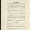
This site falls within the Tombreck 2E division of the Tummel Forest Field Survey. Site 60 (a-h) from that survey lies within its extent.
J Kenworthy 1977; NMRS MS 156/2
A farmstead comprising four unroofed buildings and one enclosure is depicted on the 1st edition of the OS 6-inch map (Perthshire 1867, sheet xxxviii). One unroofed building and one enclosure are shown on the current edition of the OS 1:10000 map (1992).
Information from RCAHMS (SAH) 20 October 1997

