
Lewis, Arnol


Lazy Beds (Post Medieval), Township(S) (Period Unassigned)
Site Name Lewis, Arnol
Classification Lazy Beds (Post Medieval), Township(S) (Period Unassigned)
Canmore ID 131433
Site Number NB34NW 2
NGR NB 3090 4880
NGR Description Centred on NB 3090 4880
Datum OSGB36 - NGR
Permalink http://canmore.org.uk/site/131433


- Council Western Isles
- Parish Barvas
- Former Region Western Isles Islands Area
- Former District Western Isles
- Former County Ross And Cromarty
NB34NW 2.00 centred on 3090 4880
Formerly NB34NW 3.
See also NB34NW 6.
2.01 3030 4830 Township; Pottery (Formerly NB34NW 2)
2.02 3060 4900 Crofting Township
2.03 3110 4860 Crofting Township
2.04 3125 4870 Structure; Enclosure
2.05 3115 4840 Enclosures
2.06 3080 4832 Buildings; Enclosures
2.07 3056 4816 Farmstead
2.08 3059 4838 Structure
2.09 3050 4827 Building
2.10 3061 4865 Building
2.11 3066 4920 Farmstead
2.12 3095 4925 Enclosures
2.13 3065 4943 Corn Mills; Enclosures
2.14 3075 4964 Buildings; Wall
2.15 310 492 Excavation (39 Arnol)
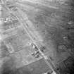
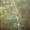
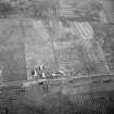
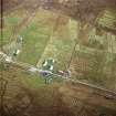
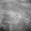
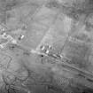
A complex landscape of pre and post-improvement townships. At least three phases of development are discernable from the 1st edition of the OS 6-inch map (Island of Lewis Ross-shire 1853, sheet 8).
The 1st phase is that of the township at the coast (2.01).
The Second phase is the failed crofting township laid along a road though the middle of the improved ground (2.02). This is similar to those elsewhere on Lewis, namely Barvas, Bragar and South Shawbost.
The third phase is the linear crofting township (2.03), which is similar again to those other townships.
A possible fourth phase is apparent when the 1st edition OS 6-inch map is compared to the present OS 1:10000 map (1974). From the maps it would appear that a small shift to the SE in the linear crofting township took place, probably after the construction of the roads and the formation of the present crofting field-system.
In addition an extensive system of head-dykes (NB24NE 52), which may be partly associated with these townships, lies to the S.
Information from RCAHMS (AKK) 18 February 1997.

