
Lewis, Barvas


Head Dyke(S) (Post Medieval), Lazy Beds (Post Medieval), Township(S) (Period Unassigned)
Site Name Lewis, Barvas
Classification Head Dyke(S) (Post Medieval), Lazy Beds (Post Medieval), Township(S) (Period Unassigned)
Canmore ID 131328
Site Number NB35SE 53
NGR NB 3600 5080
NGR Description Centred on NB 3600 5080
Datum OSGB36 - NGR
Permalink http://canmore.org.uk/site/131328


- Council Western Isles
- Parish Barvas
- Former Region Western Isles Islands Area
- Former District Western Isles
- Former County Ross And Cromarty
NB35SE 53.00 centred on 3600 5080
NB35SE 53.01 NB 3602 5103 Township; Township (possible); Farmsteads; Building
NB35SE 53.02 NB 3550 5055 Crofting Township
NB35SE 53.03 NB 3505 5015 Crofting Township
NB35SE 53.04 NB 3550 5055 Church; School House; Buildings; Enclosures
NB35SE 53.05 NB 3601 5031 Structures
NB35SE 53.06 NB 3620 5186 Farmstead
NB35SE 53.07 NB 3554 5136 Mill
NB35SE 53.08 NB 3556 5186 Field-systems; Enclosure
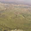
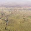
A complex landscape of pre and post-improvement townships. At least three phases of development are discernable from the 1st edition of the OS 6-inch map (Island of Lewis Ross-shire 1853, sheet 8). Some lengths of head-dyke lie to the S, E and N of this site. In addition an extensive system of head-dykes (NB34NE 39), which may be associated with these townships, lies to the SE.
The earliest settlement recorded is in the machair (see NB35SE 16). No features have been mapped by the OS.
The first mapped phase may be the relic townships which may have been scattered within the present township boundaries (see NB35SE 53.01)
This was replaced by a crofting system which has two distinct phases.
A crofting township (NB35SE 53.02) laid along three roads through the middle of the improved ground, this may have been built to replace the present crofting township but was not successful. This is similar to other townships elsewhere on Lewis, namely, Bragar and South Shawbost.
The linear crofting townships (NB35SE 53.03) which survive to the present are found next to the roads and probably replaced the pre-improvement townships (NB35SE 53.01).
Information from RCAHMS (AKK) 20 February 1997.

