
Upper Wheedlemont


Cottage (Period Unassigned), Field Boundary(S) (Period Unassigned), Hut(S) (Period Unassigned), Quarry (Period Unassigned), Sheepfold (Period Unassigned)
Site Name Upper Wheedlemont
Classification Cottage (Period Unassigned), Field Boundary(S) (Period Unassigned), Hut(S) (Period Unassigned), Quarry (Period Unassigned), Sheepfold (Period Unassigned)
Alternative Name(s) Cnoc Cailliche
Canmore ID 131081
Site Number NJ42NE 120
NGR NJ 4733 2590
Datum OSGB36 - NGR
Permalink http://canmore.org.uk/site/131081


- Council Aberdeenshire
- Parish Auchindoir And Kearn
- Former Region Grampian
- Former District Gordon
- Former County Aberdeenshire
NJ42NE 120 4733 2590
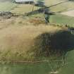
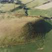
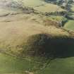
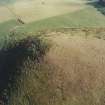
The grass-covered foundations of rectangular houses, enclosures and banks survive in fair condition on a SE-facing slope in an area of permanent pasture at an altitude of 310m OD. Several periods of building are represented and some of the remains may be of turf construction.
Visited by AAS, 30 April 1998.
NMRS, MS/712/34.
(Classification cited as farmstead and enclosures). Air photograph: AAS/00/02/CT.
NMRS, MS/712/100.
(Classification amended to cottage, huts, sheepfold, quarry and field banks). The remains of a cottage and two smaller huts are situated in rough pasture on the S flank of Cnoc Cailliche, some 370m SW of Upper Wheedlemont steading (NJ42NE 110). The cottage measures 12m from NE to SW by 5m transversely over walls reduced to grass-grown banks up to 1.3m in thickness and 0.3m in height, and there is an entrance midway along the SE side. The footings of two grass-grown huts lie end-on to the S and E corners of the building. They each measure about 7m from NW to SE by 5m transversely overall.
The remains of a square sheepfold are situated about 50m ESE of the building, on a patch of unimproved ground in an otherwise cultivated field. It measures 20m from E to W by 18m transversely within a ruined stone wall 1.2m in thickness and 0.6m in height. There is a possible entrance midway along the S side, and within the interior a low platform, measuring about 3m in breadth, runs the length of the W side. In the vicinity of the fold there are several grass-grown field-banks, including one which joins the SW corner of the fold, and another which approaches the NE corner from the N. A small quarry, measuring about 5m square and 0.6m in depth, is situated immediately N of the fold.
The fold is depicted as almost completely roofed on the 1st edition of the OS 6-inch map (Aberdeenshire, 1870, sheet xlii), although the centre is shown open, and a gap on the SE may have marked an entrance. On the 2nd edition map (1902, sheet xlii.NE) only the outline of the fold is depicted. In its earlier roofed phase it was probably a sheepfold.
Visited by RCAHMS (JRS), 2 March 2000.

