|
All Other |
MS 731/17 |
Records of the Royal Commission on the Ancient and Historical Monuments of Scotland (RCAHMS), Edinbu |
Afforestable Land Survey field database (Rogart survey, 1995). Held as attribute table in GIS and in Oracle Field/AP table. Please see DX001425 |
1995 |
Item Level |
|
|
Photographs and Off-line Digital Images |
C 53961 |
RCAHMS Aerial Photography |
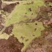
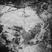
Allt Bad a' Chrasgaidh, oblique aerial view, taken from the SSW, centred on a township. A possible homestead, enclosure and building are visible in the top left-hand corner of the photograph, and a hut-circle is shown in the top right-hand corner. |
23/6/1995 |
Item Level |
|
|
Photographs and Off-line Digital Images |
C 53968 |
RCAHMS Aerial Photography |
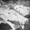
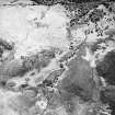
Allt Bad a' Chrasgaidh, oblique aerial view, taken from the NE, centred on a township. Hut-circles, rig and various small cairns are visible in the bottom half of the photograph, and a hut-circle is shown in the top left-hand corner. |
23/6/1995 |
Item Level |
|
|
Photographs and Off-line Digital Images |
C 53969 |
RCAHMS Aerial Photography |
Allt Bad a' Chrasgaidh, oblique aerial view, taken from the NE, centred on a township. Hut-circles, rig and various small cairns are visible in the bottom half of the photograph, and a hut-circle is shown in the top left-hand corner. |
23/6/1995 |
Item Level |
|
|
Photographs and Off-line Digital Images |
C 53957 |
RCAHMS Aerial Photography |
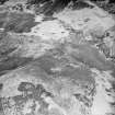
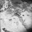
Morvich Burn, oblique aerial view, taken from the NW, centred on a township. Sheepfolds are visible in the centre top half of the photograph, a hut-circle in the centre bottom half, and enclosures, a building and a structure are shown in the centre right half. |
23/6/1995 |
Item Level |
|
|
Photographs and Off-line Digital Images |
C 53958 |
RCAHMS Aerial Photography |
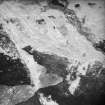
Morvich Burn, oblique aerial view, taken from the NW, centred on a township. Sheepfolds are visible in the centre top half of the photograph, a hut-circle in the bottom right-hand corner, and enclosures, a building and a structure are shown in the centre right half. |
23/6/1995 |
Item Level |
|
|
Photographs and Off-line Digital Images |
C 53966 |
RCAHMS Aerial Photography |
Morvich burn, oblique aerial view, taken from the NE, centred on a township. A hut-circle is visible in the bottom half of the photograph, and enclosures, a building and a structure are shown in the top-right hand corner. |
23/6/1995 |
Item Level |
|
|
Photographs and Off-line Digital Images |
C 46902 CN |
RCAHMS Aerial Photography |
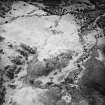
Allt Bad a' Chrasgaidh, oblique aerial view, taken from the WNW, centred on a township. A possible homestead, enclosure and building are visible in the bottom left-hand corner of the photograph, and a hut-circle is shown in the top right-hand corner. |
23/6/1995 |
Item Level |
|
|
Photographs and Off-line Digital Images |
C 53967 |
RCAHMS Aerial Photography |
Allt Bad a' Chrasgaidh, oblique aerial view, taken from the NW, showing a township and a hut-circle. |
23/6/1995 |
Item Level |
|
 |
On-line Digital Images |
SC 1693025 |
RCAHMS Aerial Photography |
Allt Bad a' Chrasgaidh, oblique aerial view, taken from the WNW, centred on a township. A possible homestead, enclosure and building are visible in the bottom left-hand corner of the photograph, and a hut-circle is shown in the top right-hand corner. |
23/6/1995 |
Item Level |
|
 |
On-line Digital Images |
SC 1693058 |
RCAHMS Aerial Photography |
Allt Bad a' Chrasgaidh, oblique aerial view, taken from the SSW, centred on a township. A possible homestead, enclosure and building are visible in the top left-hand corner of the photograph, and a hut-circle is shown in the top right-hand corner. |
23/6/1995 |
Item Level |
|
 |
On-line Digital Images |
SC 1693059 |
RCAHMS Aerial Photography |
Allt Bad a' Chrasgaidh, oblique aerial view, taken from the NE, centred on a township. Hut-circles, rig and various small cairns are visible in the bottom half of the photograph, and a hut-circle is shown in the top left-hand corner. |
23/6/1995 |
Item Level |
|
 |
On-line Digital Images |
SC 1693200 |
RCAHMS Aerial Photography |
Morvich Burn, oblique aerial view, taken from the NW, centred on a township. Sheepfolds are visible in the centre top half of the photograph, a hut-circle in the centre bottom half, and enclosures, a building and a structure are shown in the centre right half. |
23/6/1995 |
Item Level |
|
 |
On-line Digital Images |
SC 1693201 |
RCAHMS Aerial Photography |
Morvich Burn, oblique aerial view, taken from the NW, centred on a township. Sheepfolds are visible in the centre top half of the photograph, a hut-circle in the bottom right-hand corner, and enclosures, a building and a structure are shown in the centre right half. |
23/6/1995 |
Item Level |
|
 |
On-line Digital Images |
SC 1693207 |
RCAHMS Aerial Photography |
Morvich burn, oblique aerial view, taken from the NE, centred on a township. A hut-circle is visible in the bottom half of the photograph, and enclosures, a building and a structure are shown in the top-right hand corner. |
23/6/1995 |
Item Level |
|
 |
On-line Digital Images |
SC 1693208 |
RCAHMS Aerial Photography |
Allt Bad a' Chrasgaidh, oblique aerial view, taken from the NW, showing a township and a hut-circle. |
23/6/1995 |
Item Level |
|
 |
On-line Digital Images |
SC 1693209 |
RCAHMS Aerial Photography |
Allt Bad a' Chrasgaidh, oblique aerial view, taken from the NE, centred on a township. Hut-circles, rig and various small cairns are visible in the bottom half of the photograph, and a hut-circle is shown in the top left-hand corner. |
23/6/1995 |
Item Level |
|
|
Digital Files (Non-image) |
DX 001425 |
Records of the Royal Commission on the Ancient and Historical Monuments of Scotland (RCAHMS), Edinbu |
RCAHMS Structures Database - Rogart |
1995 |
Item Level |
|
|
Digital Files (Non-image) |
TM 000355 |
Records of the Royal Commission on the Ancient and Historical Monuments of Scotland (RCAHMS), Edinbu |
Zip file containing all survey linework collected during the RCAHMS Afforestable Land Survey of the Rogart area 1995. |
1995 |
Item Level |
|
|
Digital Files (Non-image) |
TM 002205 |
Records of the Royal Commission on the Ancient and Historical Monuments of Scotland (RCAHMS), Edinbu |
Zip file containing all survey linework collected during the RCAHMS Afforestable Land Survey of the Rogart area 1995. SHP and Geojson file formats with extra attribution added to the linework. |
1995 |
Item Level |
|


