 |
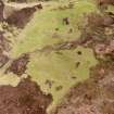
On-line Digital Images |
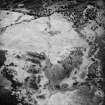
SC 1693025 |
RCAHMS Aerial Photography |
Allt Bad a' Chrasgaidh, oblique aerial view, taken from the WNW, centred on a township. A possible homestead, enclosure and building are visible in the bottom left-hand corner of the photograph, and a hut-circle is shown in the top right-hand corner. |
23/6/1995 |
Item Level |
|
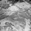 |
On-line Digital Images |
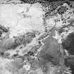
SC 1693058 |
RCAHMS Aerial Photography |
Allt Bad a' Chrasgaidh, oblique aerial view, taken from the SSW, centred on a township. A possible homestead, enclosure and building are visible in the top left-hand corner of the photograph, and a hut-circle is shown in the top right-hand corner. |
23/6/1995 |
Item Level |
|
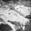 |
On-line Digital Images |
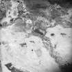
SC 1693059 |
RCAHMS Aerial Photography |
Allt Bad a' Chrasgaidh, oblique aerial view, taken from the NE, centred on a township. Hut-circles, rig and various small cairns are visible in the bottom half of the photograph, and a hut-circle is shown in the top left-hand corner. |
23/6/1995 |
Item Level |
|
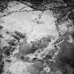 |
On-line Digital Images |
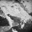
SC 1693200 |
RCAHMS Aerial Photography |
Morvich Burn, oblique aerial view, taken from the NW, centred on a township. Sheepfolds are visible in the centre top half of the photograph, a hut-circle in the centre bottom half, and enclosures, a building and a structure are shown in the centre right half. |
23/6/1995 |
Item Level |
|
 |
On-line Digital Images |
SC 1693201 |
RCAHMS Aerial Photography |
Morvich Burn, oblique aerial view, taken from the NW, centred on a township. Sheepfolds are visible in the centre top half of the photograph, a hut-circle in the bottom right-hand corner, and enclosures, a building and a structure are shown in the centre right half. |
23/6/1995 |
Item Level |
|
 |
On-line Digital Images |
SC 1693207 |
RCAHMS Aerial Photography |
Morvich burn, oblique aerial view, taken from the NE, centred on a township. A hut-circle is visible in the bottom half of the photograph, and enclosures, a building and a structure are shown in the top-right hand corner. |
23/6/1995 |
Item Level |
|
 |
On-line Digital Images |
SC 1693208 |
RCAHMS Aerial Photography |
Allt Bad a' Chrasgaidh, oblique aerial view, taken from the NW, showing a township and a hut-circle. |
23/6/1995 |
Item Level |
|
 |
On-line Digital Images |
SC 1693209 |
RCAHMS Aerial Photography |
Allt Bad a' Chrasgaidh, oblique aerial view, taken from the NE, centred on a township. Hut-circles, rig and various small cairns are visible in the bottom half of the photograph, and a hut-circle is shown in the top left-hand corner. |
23/6/1995 |
Item Level |
|


