
Lewis, Poll Eistean


Enclosure (Period Unassigned)
Site Name Lewis, Poll Eistean
Classification Enclosure (Period Unassigned)
Canmore ID 129508
Site Number NB56SW 21
NGR NB 5345 6484
Datum OSGB36 - NGR
Permalink http://canmore.org.uk/site/129508


- Council Western Isles
- Parish Barvas
- Former Region Western Isles Islands Area
- Former District Western Isles
- Former County Ross And Cromarty
NB56SW 21 5345 6484
An enclosure is depicted on the 1st edition of the OS 6-inch map (Island of Lewis, Ross-shire 1853, sheet 1) and on the current edition of the OS 1:10000 map (1992).
Information fom RCAHMS (AKK) 13 March 1997
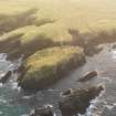
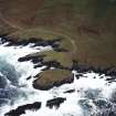
This enclosure now lies beneath a track constructed to allow access to Dun Eistean (NB56NW 1), and appears to have been one of several areas of lazy bed cultivation with different alignments that fringe the NE coast at this location (NB56NW 28).
Information from RCAHMS (SMDG) 1 February 2005

