|
Manuscripts |
MS 579 |
|
Report with area plans (1:10,000 and 1:2500) Strath Sgitheach Forestry Survey, S T Driscoll and S M Foster, 1989. |
|
Item Level |
|
|
Photographs and Off-line Digital Images |
E 11555 |
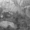
RCAHMS Aerial Photography |
General oblique aerial view centred on the remains of the field-system, enclosure and sheepfolds, taken from the ESE. |
13/7/1990 |
Item Level |
|
 |
On-line Digital Images |
SC 2011275 |
RCAHMS Aerial Photography |
General oblique aerial view centred on the remains of the field-system, enclosure and sheepfolds, taken from the ESE. |
13/7/1990 |
Item Level |
|
 |
On-line Digital Images |
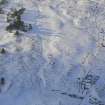
DP 341935 |
Papers of James Sloan Bone, landscape historian, Inverness, Highland, Scotland |
Aerial view of Strath Sgitheach sheepfold and hut circle settlement, near Dingwall, Easter Ross, looking NW. |
22/1/2010 |
Item Level |
|
 |
On-line Digital Images |
SC 2363121 |
Records of the Ordnance Survey, Southampton, Hampshire, England |
Strath Sgitheach, NH56SW 27, Ordnance Survey index card, Recto |
1958 |
Item Level |
|


