
Pricing Change
New pricing for orders of material from this site will come into place shortly. Charges for supply of digital images, digitisation on demand, prints and licensing will be altered.
Upcoming Maintenance
Please be advised that this website will undergo scheduled maintenance on the following dates:
Thursday, 30 January: 11:00 AM - 3:00 PM
During these times, some functionality such as image purchasing may be temporarily unavailable. We apologise for any inconvenience this may cause.
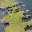
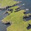
Hog Sound


Fort (Period Unassigned)
Site Name Hog Sound
Classification Fort (Period Unassigned)
Canmore ID 1293
Site Number HU55NW 2
NGR HU 5081 5813
Datum OSGB36 - NGR
Permalink http://canmore.org.uk/site/1293


- Council Shetland Islands
- Parish Nesting
- Former Region Shetland Islands Area
- Former District Shetland
- Former County Shetland
HU55NW 2 5081 5813.
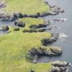
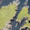
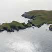
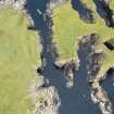
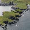
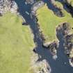
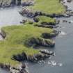
HU 5081 5816. Along the edge of the mainland on the west side of Hog Sound are the remains of three turf-covered ramparts of earth and stone with no evidence of ditches between them. The outer rampert is 0.7m high, the other two 0.5m high. An entrance is marked by a break through the centre of each rampart. No evidence of fortification was seen on Hog Island itself, except for the remains of a stone wall or rampart along the cliff edge on the east side of Hog Sound. It would appear that Hog Island was formerly joined to the mainland.
Surveyed at 1/2500.
Visited by OS(WDJ) 22nd June 1968; R G Lamb 1980.
Note (3 March 2016 - 30 May 2016)
The defences of this probable fort are amongst the most extraordinary to have been recorded in Shetland, and escaped record until discovered by an OS surveyor in 1968. They comprise a belt of three ramparts reduced to banks about 3m thick and from 0.5m to 1m in height, and, rather than ditches, they are separated by shallow quarry scoops about 4.5m in breadth. The ramparts form a shallow arc that now backs onto the edge of a cliff some 10m high, and apparently mark the landward end of a promontory fort that once extended out onto Hog Island, from which it is now separated from by a chasm 18m wide. An entrance lies midway along the arc, piercing all three ramparts, and a plan drawn up by Raymond Lamb shows a series of large boulders set to either side of the gap through the middle rampart, and another two on the cliff-edge in the gap in the inner rampart (1980, 45, fig 15). Projecting the axis of this entrance across the geo to the island, Lamb observed another pair of large boulders set in the leading edge of the remains of a ruined wall extending along the cliff-edge at the W end of the island, though the OS surveyor was of the opinion that this was not part of the fortifications. At face value, it appears that the island was once linked to the mainland by a neck some 35m wide, and essentially represents the interior of a large promontory fort, though whether it really extended the full length of the island, which measures some 230m in length, or whether there was a barrier set at the next narrow neck to the E is unclear. The consequences for the size of the fort are extreme, for while the W end of the island measures no more than 65m from NNE to SSW by 30m transversely (0.13ha), eastwards beyond this neck, now 10m wide, it expands out to between 170m and 60m in breadth, representing an overall area of about 2ha. The OS surveyor crossed over to the island and the only feature he recorded was a roughly rectangular arrangement of seven granite boulders on the summit (RCAHMS Canmore 1292); this is named Egils House on the 1st edition OS 6-inch map (Shetland 1880, sheet 44; Name Book, Shetland, No.5, p 53), though the name has perhaps been transposed from a drystone rectangular pen or building visible on satellite imagery a little further ESE (HU 5103 5807). This stucture measures about 5.5m from NW to SE by 4m transversely overall, and has an entrance in its SE end.
Information from An Atlas of Hillforts of Great Britain and Ireland – 30 May 2016. Atlas of Hillforts SC4191

