
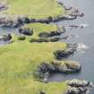
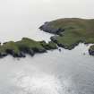
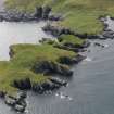
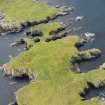
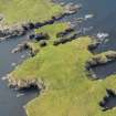
Egils House, Hog Island


Structure (Period Unassigned)
Site Name Egils House, Hog Island
Classification Structure (Period Unassigned)
Canmore ID 1292
Site Number HU55NW 1
NGR HU 5100 5807
Datum OSGB36 - NGR
Permalink http://canmore.org.uk/site/1292


- Council Shetland Islands
- Parish Nesting
- Former Region Shetland Islands Area
- Former District Shetland
- Former County Shetland
HU55NW 1 5100 5807
(HU 5100 5810) Egil's House (TI)
OS 6"map, Shetland, 2nd ed.,(1903).
'Eagles' or Egils' House: a small object "having much the appearance of a stone cist, but for what purpose it was used or named could not be ascertained. It is situate on the highest point of Hog Island, and commands a view all round."
Name Book 1878
Seven rough granite boulders, the largest c.0.7m high, forming a rough rectangle 2.0m. x 1.0m. It is situated on natural rock outcrop with barely 0.2m. of top-soil, several of the boulders being quite loose. There is no evidence of cairn material and this would appear to be an ancient look-out post or sea marker point rather than a cist.
Visited by OS(WDJ) 22nd June 1968
One unroofed structure is depicted on the 1st edition of the OS 6-inch map (Orkney & Shetland (Shetland) 1880, sheet xliv) and on the current edition of the OS 1:10000 map (1973).
Information from RCAHMS (SAH) 17 May 2001

