
Pricing Change
New pricing for orders of material from this site will come into place shortly. Charges for supply of digital images, digitisation on demand, prints and licensing will be altered.
Edinburgh, 31 East Preston Street, Newington Old Burial Ground


Burial Ground (19th Century) (1820)
Site Name Edinburgh, 31 East Preston Street, Newington Old Burial Ground
Classification Burial Ground (19th Century) (1820)
Alternative Name(s) Dalkeith Road; Churchyard
Canmore ID 129117
Site Number NT27SE 2626
NGR NT 26643 72372
Datum OSGB36 - NGR
Permalink http://canmore.org.uk/site/129117


- Council Edinburgh, City Of
- Parish Edinburgh (Edinburgh, City Of)
- Former Region Lothian
- Former District City Of Edinburgh
- Former County Midlothian
NT27SE 2626.00 26643 72372
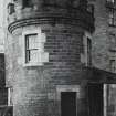
NT27SE 2626.01 26635 72391 Watch Tower
Opened 4 December 1820 as extension of Buccleuch Churchyard (NT27SE 1975).
(Undated) information in NMRS.
INVENTORY OF GRAVEYARD AND CEMETERY SITES IN SCOTLAND REFERENCE:
N.B. This reference applies collectively to NT27SE 2626.00 and NT27SE 2626.01
Address: Newington Old Burial Ground and Watch Tower, East Preston Street, Edinburgh
Postcode: EH16 5BS
Status: Closed for burials but maintained
Size: 0.91 hectares, 2.25 acres
Polygon: No
TOIDs:
Number of gravestones: Not known
Earliest gravestone: Not known
Most recent gravestone: Not Known
Description: Early municipal burial ground opened 4 December 1820, with watch tower and iron railing mortsafe enclosure.
Data Sources: OS MasterMap checked 15 September 2005; Bereavement Services Portal checked 15 September 2005
Standing Building Recording (3 March 2022)
NT 26539 72345 AOC Archaeology Group carried out a historic building survey of a boundary wall adjoining the East Preston Street Cemetery prior to the demolition and redevelopment of an adjacent warehouse to the west. The boundary wall is likely unchanged since the mid-20th century with the removal of the individual plots running along the western wall. It remains in a good condition with 17 wall monuments along its 50m length of which 12 are located within the survey area with dates ranging from the early 19th to the early 20th century.
Information from R. Usher - AOC Archaeology Group, 2022.
OASIS ID: aocarcha1-436143

